Tornado risk, large hail expected in southern Ontario on Saturday
A widespread risk for severe thunderstorms will develop across southern Ontario on Saturday as a robust low-pressure system pushes into the region.
The height of the system will impact the region during the afternoon hours and continue through the evening.
WEATHER ALERT: Due to incoming severe weather, we are evacuating the entertainment area. Seek shelter inside your vehicles. We will update as soon as possible.
WEATHER ALERT: Due to incoming severe weather, we are evacuating the entertainment area. Seek shelter inside your vehicles. We will update as soon as possible.
— Boots and Hearts (@BootsandHearts) Boots and Hearts on Twitter: "WEATHER ALERT: Due to incoming severe weather, we are evacuating the entertainment area. Seek shelter inside your vehicles. We will update as soon as possible. / Twitter"
All modes of severe weather are possible. Dynamics are in place for some of the storms to acquire rotation, so residents should stay vigilant for the threat of a tornado or two. Very large hail is also possible. Severe storms around Lake Simcoe produced hail the size of golf balls and larger in the 3:00-4:00 p.m. hour.
Funnel clouds were spotted near the airport in Hamilton as well as in Caledonia during the first round of storms on Saturday morning.
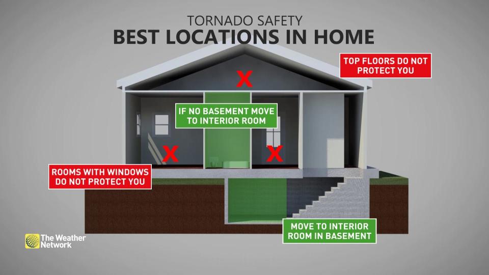
Pay close attention to severe weather alerts in your area through Saturday, and have a safety plan in place if threatening weather approaches whether you’re at home or on the road.
Funnel cloud Mount Hope. Just south of Hamilton Airport. 10:20am #ONStorm pic.twitter.com/d4CSVMBGey
Funnel cloud Mount Hope. Just south of Hamilton Airport. 10:20am Patrick S on Twitter: "Funnel cloud Mount Hope. Just south of Hamilton Airport. 10:20am #ONStorm pic.twitter.com/d4CSVMBGey / Twitter" Patrick S on Twitter: "Funnel cloud Mount Hope. Just south of Hamilton Airport. 10:20am #ONStorm pic.twitter.com/d4CSVMBGey / Twitter"
— Patrick S (@PScherm406) Patrick S on Twitter: "Funnel cloud Mount Hope. Just south of Hamilton Airport. 10:20am #ONStorm pic.twitter.com/d4CSVMBGey / Twitter"
STAY SAFE: Don't fall victim to these seven dangerous tornado myths
Saturday
Location: Southern Ontario
Timing: Starting in the morning, lasting through the evening
Weather:
Behind Saturday's first round of storms, we’ll see a favourable environment build for a second, more potent batch of thunderstorms to develop throughout southern Ontario by Saturday afternoon.

A low-pressure system moving over the province will funnel plenty of instability and moisture north of the border, providing the fuel needed for storms to form and quickly turn severe.
All modes of severe weather are possible on Saturday, with strong winds, large hail, heavy rain, and even a couple of tornadoes possible in the strongest storms. The storms will develop by the afternoon hours and continue east through the day.
WATCH: Festival near Barrie, Ontario, evacuated due to severe weather
A few areas that should pay particularly close attention to watches and warnings on Saturday include the 401 corridor near London, Essex County, the Niagara Region, and east of the GTA south of Highway 7 as they have the possibility of seeing rotating storms and one or two tornadoes.
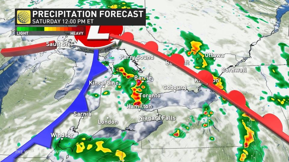
Winds aloft will allow some of the storms to grow into supercells—storms that contain rotating updrafts, enhancing their ability to produce large hail, strong winds, and a risk for tornadoes.
Heavy rainfall could lead to a threat of localized flooding, especially in eastern Ontario where we saw torrential rains on Thursday.
Prepare
Ensure you have a way to receive severe weather alerts the moment they’re issued. Have a safety plan in place in case threatening weather approaches your location, especially if you plan to spend time outdoors over the next few days.
Motorists should stay alert for standing water on roads. Never try to drive through standing water. It’s impossible to tell how deep the water is until it’s too late, and the road may have been washed out beneath the water.
Stay tuned to The Weather Network for updates on your forecast in southern Ontario.

