NWS says no damage reported with Parker tornado warning
Update as of 8:58 p.m.: The severe thunderstorm watch has now also expired for Lincoln County, according to NWS.
Northwestern IA and southwestern MN, it's your turn for some thunderstorms. While storms have weakened, they are still producing heavy rain and some gusty winds up to 50 mph. They are moving quickly and should be east of our area by around 10 PM. pic.twitter.com/MKV0FxlPEU
— NWS Sioux Falls (@NWSSiouxFalls) October 4, 2023
Update as of 8:36 p.m.: The NWS reported on X that there was no reported damage from the tornado warning issued earlier in the night, only heavy rain and wind.
"It's likely what we were seeing was a mesovortex embedded within the line of storms, which is pretty common," the NWS posted. "They can drop tornadoes too, but it looks like we lucked out tonight."
Yep, that's the most difficult part about lines of thunderstorms like this. They can have strong spin ups that will drop a very brief tornado. There one scan, gone the next.
— NWS Sioux Falls (@NWSSiouxFalls) October 4, 2023
The severe thunderstorm watch has also expired for Minnehaha County, according to NWS. The watch is still active until 11 p.m. for Lincoln County.
Update as of 7:15 p.m.: The warning has since expired, but those along the I-29 corridor and east should remain weather aware, according to the NWS.
"Strong thunderstorms that are producing heavy rains, frequent lighting, and gusty winds is headed your way," the service posted on X. "Please stay weather aware and have multiple ways to receive warnings tonight."
Update as of 6:58 p.m.: The NWS has issued a tornado warning until 7:15 p.m. for the areas of Parker, Marion and Canistota.
The tornado is radar indictated. It's unclear at this time whether there is damage in the area. The NWS urged those in the path of the storm to seek shelter now.
Heads up everyone northeast of Freeman SD. There is a tornado warning until 7:15 pm tonight. This storm is moving northeast toward Marion and Monroe SD. Take shelter now!! pic.twitter.com/4La5Xbw2P8
— NWS Sioux Falls (@NWSSiouxFalls) October 3, 2023
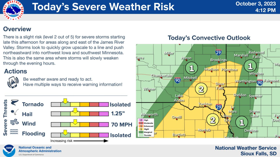
Earlier story: Minnehaha and Lincoln counties are under a severe thunderstorm watch until 11 p.m., according to the National Weather Service.
Forecasts show Sioux Falls could receive at least another inch of rain before Wednesday morning, with slight risks of large hail and damaging winds, along with isolated possibilities of flooding and tornadoes, throughout southeastern South Dakota.
Storms in the area are expected to end before 1 a.m., with skies clearing for Wednesday.
Follow @argus911 on X, formerly Twitter, for live updates. We will update this page with major developments, accordingly.
Whats next for Sioux Falls weather?
The forecast for the next several days is as follows:
This Afternoon: Isolated showers and thunderstorms. Cloudy, with a steady temperature around 73. South wind around 15 mph, with gusts as high as 30 mph. Chance of precipitation is 20%.
Tonight: Showers and thunderstorms, mainly before 1am. Low around 54. South wind 10 to 15 mph becoming west after midnight. Winds could gust as high as 25 mph. Chance of precipitation is 100%. New rainfall amounts between a half and three quarters of an inch possible.
Wednesday: Mostly sunny, with a high near 66. West northwest wind around 15 mph, with gusts as high as 25 mph.
Wednesday Night: Mostly clear, with a low around 50. South southwest wind 5 to 10 mph.
Thursday: Sunny, with a high near 63. Breezy, with a west northwest wind 15 to 25 mph, with gusts as high as 35 mph.
Thursday Night: Partly cloudy, with a low around 42. Breezy, with a west northwest wind 15 to 20 mph, with gusts as high as 30 mph.
Friday: Partly sunny, with a high near 51. Breezy.
Friday Night: Areas of frost after 5 a.m. Otherwise, mostly clear, with a low around 35. Breezy.
Saturday: Areas of frost before 9 a.m. Otherwise, sunny, with a high near 54.
Saturday Night: Areas of frost after 5 a.m. Otherwise, mostly clear, with a low around 36.
Sunday: Areas of frost. Otherwise, sunny, with a high near 65.
Sunday Night: Clear, with a low around 42.
Columbus Day: Sunny, with a high near 69.
Monday Night: Mostly clear, with a low around 44.
Tuesday: Sunny, with a high near 71.
This article originally appeared on Sioux Falls Argus Leader: Severe thunderstorm watch expires for southeastern South Dakota

