Update: Tornado watch added, severe thunderstorms expected in Asheville; 'damaging winds'

Updated with tornado watch information.
ASHEVILLE - Severe thunderstorms are expected in Western North Carolina the afternoon of Aug. 7 as a line of "intense" storms track across the region, and a National Weather Service meteorologist says damaging winds pose the primary threat for Asheville, though hail and isolated tornadoes are not ruled out.
According to NWS, the strong storm system is tracking eastward from the lower Great Lakes and Midwest, with an associated cold front likely reaching the mid-Atlantic coast late in the night, and numerous thunderstorms expected ahead of its sweep.
Asheville is classified as an enhanced risk, a 3 out of 5 in the severe thunderstorm risk categories, which means numerous severe thunderstorms are possible. Meteorologist Mike Rehnberg said while not unheard of, "it's definitely the kind of thing that raises our eyebrows, it's not something we see all the time."
A "handful" of enhanced risks occur in the area each year, he said, but it's "uncommon" in a summer month like August.
“Normally when we see these pretty elevated severe weather risks that’s something that we see in spring, think late March into the month of May," Rehnberg told the Citizen Times the morning of Aug. 7. "Usually we don’t expect them this time of year, but it’s not unheard of for the Carolinas to see this.”
The last enhanced thunderstorm risk for Asheville was March 3.
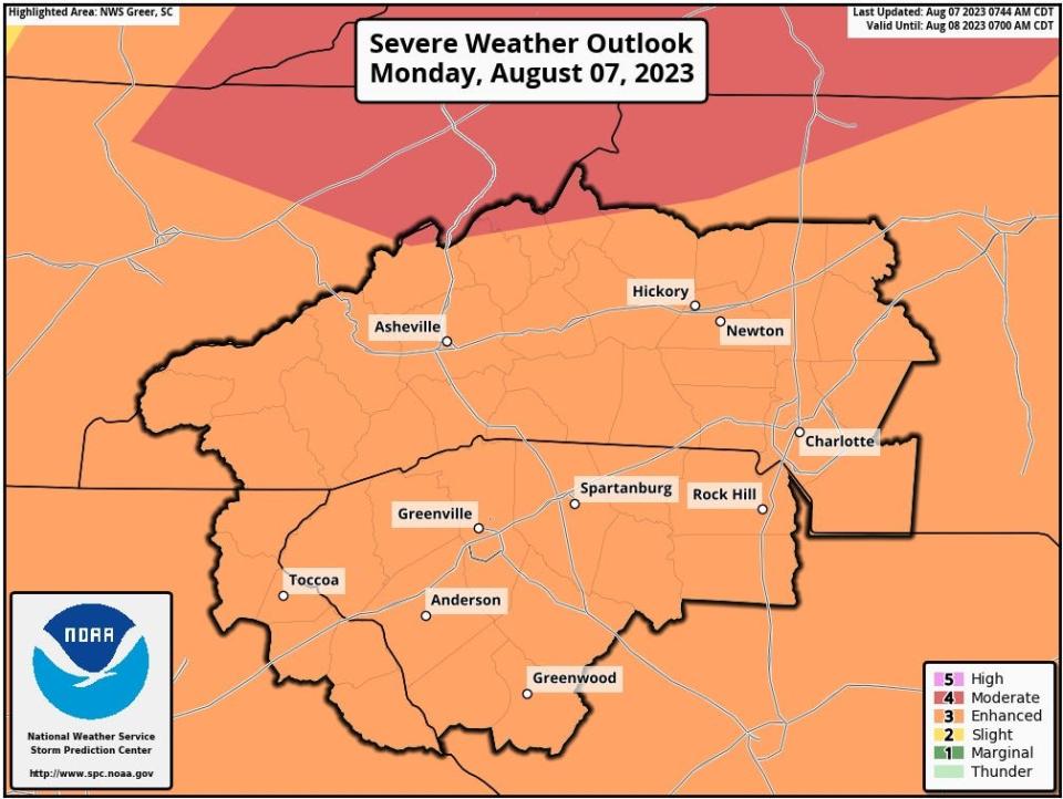
A "small sliver" of the mountains north of Asheville has been upgraded to a moderate risk, a 4 out of 5 on the scale, which includes areas near Burnsville in Yancey County and Newland in Avery County, and indicates more long-lived, intense and widespread severe storms.
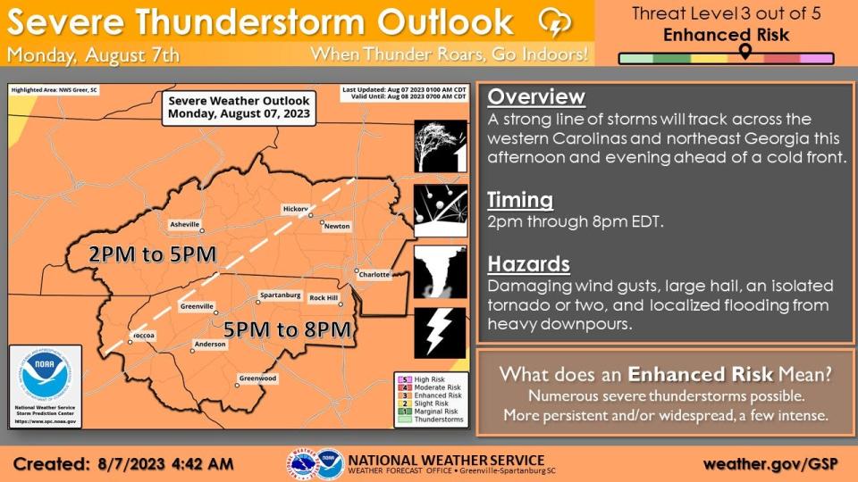
Primary threat for Asheville
As the line of storms sweeps across the Carolinas, Rehnberg said they anticipate "bowing line segments," or “localized, really strong wind gusts,” which could cause severe wind damage in the region.
The storms are anticipated to hit the region beginning at 3 p.m. and lasting into the evening, likely slowing by 5 p.m., though some rain showers may linger.
There is a 50% chance of severe winds, with expected bursts of 60-70 mph, Rehnberg said. A chance of hail hovered around 15-20% and the tornadic risk below 10%.
“We could see hail with this and there’s even a passing chance of an isolated weak tornado, but these are not the kind of things that are the primary threats for this event,” he said.
"But once severe risk pushes through the area it will end pretty quickly after that."
Though downpours are expected, they will be brief, and the official forecast is for less than a quarter inch of rainfall, not sticking around long enough to cause widespread flooding.
Cloud-to-ground lightning, locally heavy rainfall and gusty winds are expected with any thunderstorms that develop, according to the hazardous weather outlook issued early Aug. 7.
Heat advisories are in effect for areas south and east of Asheville, but not Buncombe County itself, with a high of 90 degrees predicted, about five degrees over normal.
Update, 12:30 p.m.:
A tornado watch has been issued for parts of North Carolina and Tennessee, including Asheville.
The watch is in effect until 7 p.m., and indicates conditions are favorable for the development of tornadoes in and close to the watch area. As of 1 p.m., NWS meteorologist Doug Outlaw told the Citizen Times that Henderson and Transylvania counties were not included in the watch area.
"Watches could be issued for the foothills and Piedmont counties later, but currently the tornado watch for Tennessee, Kentucky and North Carolina mountains is effective until 7 p.m. and there is currently severe thunderstorms to the northwest of Knoxville and over into the Crossville, Tennessee area, and moving toward the North Carolina mountains," Outlaw said.
He expects thunderstorms to hit the North Carolina mountains around 1:30-2 p.m., with the bulk of the storm arriving at 3-4 p.m., moving out of the mountains around 6-7 p.m.
"The thunderstorms are going to be moving through the area pretty quickly, and there is going to be heavy rain and lightning and strong winds, and the heavy downpours are going to last a brief period of time, and hopefully it won't be enough rain at any one location to cause any flooding, but there is a small possibility of that," Outlaw said. He advised everyone be prepared for "what's on the way."
At 12:25 p.m., Duke Energy Progress sent out an emailed notification warning of expected storms and high winds, with "power outages likely."
They reminded people to "always avoid downed power lines," and "if you come across damaged equipment, maintain a safe distance and report to local emergency services and to Duke Energy as quickly as possible."
What to do when severe weather strikes
According to the NWS, acting quickly is key to staying safe and minimizing impacts.
Stay Weather Ready: Continue to listen to local news or NOAA Weather Radio to stay updated about severe thunderstorm watches and warnings.
At Your House: Go to your secure location if you hear a severe thunderstorm warning. Damaging wind or large hail may be approaching. Take your pets with you if time allows.
At Your Workplace or School: Stay away from windows if you are in a severe thunderstorm warning and damaging wind or large hail is approaching. Do not go to large open rooms such as cafeterias, gymnasiums or auditoriums.
Outside: Go inside a sturdy building immediately if severe thunderstorms are approaching. Sheds and storage facilities are not safe. Taking shelter under a tree can be deadly. The tree may fall on you. Standing under a tree also put you at a greater risk of getting struck by lightning.
In a Vehicle: Being in a vehicle during severe thunderstorms is safer than being outside; however, drive to the closest secure shelter if there is sufficient time.
Sarah Honosky is the city government reporter for the Asheville Citizen Times, part of the USA TODAY Network. News Tips? Email shonosky@citizentimes.com or message on Twitter at @slhonosky. Please support local, daily journalism with a subscription to the Citizen Times.
This article originally appeared on Asheville Citizen Times: What to know: Severe thunderstorms expected in Asheville

