Tornadoes threaten Shawnee, Bethel Acres; severe storms, hail persist across Oklahoma
Numerous severe storms are moving across Oklahoma Wednesday evening with tornadoes developing, and ongoing large hail and damaging winds.
7:11pm - Storms continue across central and southwestern Oklahoma. Large hail has been widely reported with these storms.
Two areas of possible tornadoes near Blanchard and near Midwest City.
Stay weather aware this evening!#okwx #texomawx #txwx pic.twitter.com/RkskUjlGBX— NWS Norman (@NWSNorman) April 20, 2023
Tornado confirmed; Shawnee, Bethel Acres residents advised to take shelter
9:45 p.m.
9:45pm - A STORM WITH A TORNADO IS ONGOING NORTHWEST OF TECUMSEH AND SOUTHWEST OF SHAWNEE, HEADING FOR SHAWNEE!
IF YOU'RE IN SHAWNEE, TAKE COVER IMMEDIATELY!#okwx https://t.co/vhA0c8eCOz— NWS Norman (@NWSNorman) April 20, 2023
Just had a very close brush with the tornado currently hitting #shawnee, #Oklahoma. Lots of damage near the airport and fair grounds. Smell of gas in the air. #okwx pic.twitter.com/QDVjKJQmKU
— Chimera Comstock (@SvrWxChaser) April 20, 2023
The storm threatening Shawnee and the storm previously over Cole both exhibited unusual, erratic behavior, according to the National Weather Service.
9:51pm - THIS IS ANOTHER CASE OF THE STORM HAVING ERRATIC BEHAVIOR.
THE STORM IS EXHIBITING A FUJIWARA EFFECT, WITH THE CIRCULATIONS ROTATING AROUND EACH OTHER.
DO NOT ANTICIPATE STORM MOTION, TAKE COVER IF YOU'RE IN THE WARNING.#okwx https://t.co/QjPUKDOG3s— NWS Norman (@NWSNorman) April 20, 2023
-Cheyenne Derksen
Tornado warning for Shawnee, Bethel Acres, Dale
9:30 p.m.
A tornado warning is in effect for Shawnee, Bethel Acres and Dale until 10:15 p.m.
Tornado Warning including Shawnee OK, Bethel Acres OK and Dale OK until 10:15 PM CDT pic.twitter.com/PJfhUqzLAJ
— NWS Tornado (@NWStornado) April 20, 2023
-Josh Dulaney
Tornado reported north of Pink, Oklahoma
9:29 p.m.
The National Weather Service reports a second tornado north of Pink. The tornado is moving rapidly to the northwest. Those near Stella or south of Newalla are urged to take precautions immediately.
9:21pm - A secondary tornado has developed north of Pink, that is rapidly moving to the northwest.
If you're east of Stella or south of Newalla, take your storm precautions now!#okwx https://t.co/4b9tZhDzk0— NWS Norman (@NWSNorman) April 20, 2023
-Josh Dulaney
Storm near Lake Thunderbird could produce tornado
9:17 p.m.
The National Weather Service reports a storm with the potential of producing a tornado is near Lake Thunderbird. Those in the path are urged to take precautions immediately.
9:12pm - A storm with the potential of producing a tornado is near Lake Thunderbird!
If you're in the path of this storm, take your storm precautions immediately!#okwx https://t.co/CkqLfo7LxY— NWS Norman (@NWSNorman) April 20, 2023
-Josh Dulaney
Tornado reported west of Etowah
8:48 p.m.
The National Weather Service reports a tornado west of Etowah. Those in the path are urged to take shelter immediately.
8:44pm - A tornado is on the ground west of Etowah! If you are in the path of this storm, seek shelter immediately!#okwx https://t.co/E50bA7AKEw
— NWS Norman (@NWSNorman) April 20, 2023
-Josh Dulaney
Tornado near Cole dissipated, but hail continues
8:13 p.m.
The National Weather Service reported the tornado near Cole dissipated but large hail is still ongoing.
8:13pm - The tornado has occluded and dissipated.
While the tornado threat has reduced significantly, large hail is still ongoing with this storm!
Stay safe!#okwx https://t.co/0X6llT7jr5— NWS Norman (@NWSNorman) April 20, 2023
The “large and extremely dangerous” tornado rolled through southeastern Cleveland and west-central McClain counties, according to the National Weather Service.
The tornado tore down power lines and apparently pulled roofs off structures near Cole, a town of more 600 people, video shows. Fewer than 5,000 homes and businesses were without power, according to the tracking site PowerOutage.us.
-Josh Dulaney
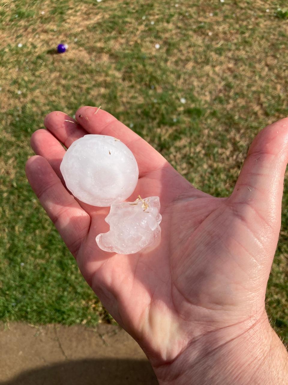
Golfball, baseball size hail batters Oklahoma in several storms
8:12 p.m.
AccuWeather's @BillWadell recorded as a 3-inch hail hit his windshield and nearly burst into the truck in Blanchard, OK. #OKwx pic.twitter.com/LfXEzAAyQ9
— AccuWeather (@accuweather) April 20, 2023
-Cheyenne Derksen
Tornado near Cole behaving erratically
8:05 p.m.
The National Weather reports a significant tornado northeast of Cole is moving in an erratic manner. People are urged to take shelter immediately.
Intense large #tornado Cole, Oklahoma. Deployed subsonic sensor for infrasound. 4 homes damaged pic.twitter.com/bMwjuMVChM
— Reed Timmer, PhD (@ReedTimmerAccu) April 20, 2023
7:58pm - A SIGNIFICANT TORNADO IS ONGOING NORTHEAST OF COLE. THE TORNADO'S MOTION IS ERRATIC. DO NOT ANTICIPATE THIS STORM MOTION.
IF YOU ARE WITHIN THE WARNING, TAKE SHELTER IMMEDIATELY.
THIS IS A SERIOUS SITUATION!#okwx https://t.co/gEELgij6za— NWS Norman (@NWSNorman) April 20, 2023
-Josh Dulaney
Wide tornado confirmed near Blanchard, Cole, Dibble
7:40 p.m.
The National Weather Service has confirmed a large and extremely dangerous tornado was located over Cole, Oklahoma, moving east at 20 mph. NWS advises people to take shelter immediately.
A tornado warning remains in effect until 8 p.m. for southeastern Cleaveland and west central McClain counties.
7:36pm - A CONFIRMED TORNADO NORTHEAST OF DIBBLE WILL IMPACT COLE HERE IN THE NEXT 5 MINUTES!
IF YOU'RE IN COLE, TAKE SHELTER IMMEDIATELY!#okwx https://t.co/ZhHOITXEXE— NWS Norman (@NWSNorman) April 20, 2023
-Josh Dulaney
Tornado moving near Tinker Air Force Base
7:11 p.m.
Just after 7 p.m., the National Weather Service reported a storm with a reported tornado near Tinker Air Force Base.
7:05pm - Storm with a reported tornado is ongoing in eastern OKC, near Midwest City!
If you're in the path of the storm (Del City, Choctaw), take shelter immediately!#okwx https://t.co/5jL2H4bZPu— NWS Norman (@NWSNorman) April 20, 2023
-Josh Dulaney
Severe thunderstorm warning for Kingfisher County, Caddo County, Blaine County and Canadian County
6:30 p.m.
The National Weather Service in Norman issued a severe thunderstorm warning for Kingfisher County, Caddo County, Blaine County and Canadian County. Storms could bring up to 60 mph wind gusts and half dollar size hail.
In addition, the NWS issued a tornado warning for Moore, Newcastle, and Hall Park.
6:20pm - A severe thunderstorm capable of producing a tornado is currently entering into western Cleveland county!
If you're in the path of the storm, take shelter immediately!!#okwx https://t.co/UGUe4d7yWv— NWS Norman (@NWSNorman) April 19, 2023
-Cheyenne Derksen
Hail pelts northwestern Oklahoma City
Earlier in the afternoon, northwestern Oklahoma City and Edmond residents saw golfball-size hail.
-Cheyenne Derksen
This article originally appeared on Oklahoman: Tornado warning for Shawnee, Bethel Acres; tornado touches down near Cole

