Northern Ingham County got the most rain in overnight storms
Updated 9:30 a.m.
GRAND RAPIDS − The Lansing area suffered some wind damage between 5 p.m. and 6:30 p.m. on Sunday night as storms moved through Ingham, Eaton and Clinton counties but avoided any large impact, said Scott Thomas, a meteorologist with the National Weather Service Grand Rapids office.
Winds gusted at an estimated 60 miles per hour in parts of Ingham County during the storm, he said, causing the most damage near Williamston and Webberville, where a downed tree was reported.
That was the worst of the damage, Thomas said. There were no reports of hail or tornadoes, he said.
The northeastern areas of Ingham County received up to two-thirds of an inch of rainfall, the most that fell in the Lansing area on Sunday night, Thomas said.
There were reports of "about three-tenths of an inch" of rainfall near Laingsburg and "two-hundredths of an inch" near Eaton Rapids and Vermontville in Eaton County, he said.
In Ingham County, near Lansing and Mason, the area saw about the same amount of rainfall as Eaton Rapids and Vermontville, Thomas said.
"We are looking at some showers in the area today," he said on Monday morning. "No risk of severe weather, no risk of thunderstorms and then we could see a few scattered showers throughout the week but the chances are much lower."
That rainfall, expected to be about a third of an inch, should move through the Lansing area but late afternoon, Thomas said.
Severe thunderstorms exit area, leaving some power outages, downed trees
Updated 7 p.m.
GRAND RAPIDS — The National Weather Service Grand Rapids office said severe thunderstorms had exited west Michigan as of 6:45 p.m. today, leaving behind scattered power outages and some downed trees.
According to the Consumers Energy outage map, the largest outages included about 677 customers in an area along M-66 north of Nashville and south of Lake Odessa. A second outage of about 250 customers was affecting an area near Leslie.
The Lansing Board of Water and Light and Homeworks Tri-County Electric Cooperative reported fewer than 10 outages affected a handful of customers.
Updated 5 p.m.
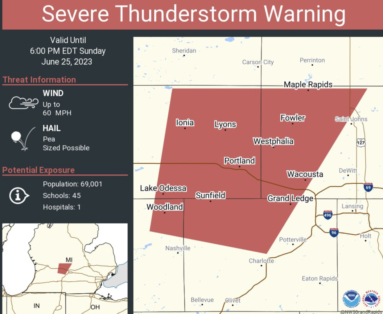
GRAND RAPIDS — The National Weather Service Grand Rapids office has issued a severe thunderstorm warning for portions of Eaton, Ingham, Clinton and Ionia counties.
The severe thunderstorm warning continues for that area until 6 p.m.
A severe thunderstorm watch remains in effect for other areas.
Severe thunderstorms possible this evening: NWS
GRAND RAPIDS — The National Weather Service has issued a severe thunderstorm watch for mid-Michigan through 7 p.m. Sunday night.
A watch means conditions can lead to the formation of thunderstorms in the watch area, which includes all of the Lower Peninsula from Benton Harbor to Traverse City, and from Lake Michigan to east of the U.S. 127 corridor.
Potential threats today and tonight include tornadoes, hail, winds up to 70 mph, localized flooding and substantial rain.
Radar images from the NWS show thunderstorms forming over Lake Michigan and moving northeast.
"Storms will move on shore within the next 60-90 minutes. Damaging wind gusts, large hail, and heavy rain are the main threats. Take shelter as storms approach your area," the NWS said at 2:45 p.m.
This article originally appeared on Lansing State Journal: Northern Ingham County got the most rain in overnight storms

