Severe thunderstorms possible as Sacramento region braces for more rain. Here’s the latest
Severe thunderstorms are possible across the Sacramento Valley as another atmospheric river storm drenches the region.
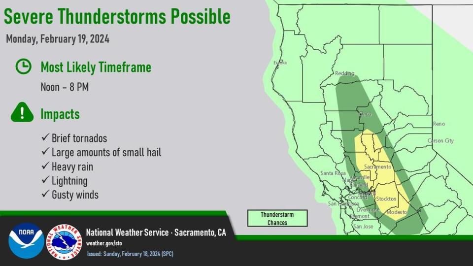
There’s a slight risk of brief tornadoes, light hail, heavy rain and gusty winds on Monday from north of Chico and south to Stockton, including most of Sacramento County, according to the National Weather Service.
Meteorologist Dakari Anderson with the weather service urged residents to keep up-to-date with forecasts as this storm system moves across the Valley and have “multiple modes of communication” to receive reports.
The most likely time frame, the weather service states, is noon to 8 p.m. Another 1 to 1.5 inches of rain is expected in Sacramento, with heavier precipitation in the foothills.
Flood watch and wind advisory for Sacramento region
The Sacramento Valley and foothills are under a flood watch until early Wednesday morning, when the storm is predicted to peter out.
In the past 24 hours, as of Monday morning, downtown Sacramento measured 1.55 inches of rain. Water rescuers were dispatched in both south Sacramento County and El Dorado Hills as localized flooding swept creeks and roadways.
The @NWSSPC has expanded the Slight Risk (Chico to Modesto) for the Valley. Be ready to take action this afternoon/evening in the event of severe weather in your area. #Cawx https://t.co/I7N0hcv7Gs pic.twitter.com/DwcnkCBjYk
— NWS Sacramento (@NWSSacramento) February 19, 2024
The weather service also issued a wind advisory for the region until early Tuesday morning. Winds are expected between 20 and 30 mph with gusts up to 50 mph.
“Gusty winds could blow around unsecured objects,” the advisory states. “Tree limbs could be blown down and a few power outages may result.”
Weekend rain totals in the Sacramento region
Here’s how much rain fell across the region from Saturday to Monday morning, Anderson said:
Sacramento Executive Airport: 1.87 inches
Sacramento International Airport: 1.25 inches
Downtown Sacramento: 1.94 inches
Rocklin: 3.51 inches
Auburn Airport: 2.25 inches
Orangevale: 1.56 inches
Redding: 3.64 inches
Red Bluff: 2.24 inches
Marysville/Yuba County: 1.62 inches
Lincoln: 1.17 inches
Stockton: 0.58 inches
Modesto: 0.89 inches
How high are Sacramento-region rivers expected to rise?
State river watchers are keeping their eyes on waterways up and down the Sacramento Valley.
The free-flowing Cosumnes River at Michigan Bar near Rancho Murieta reached its 7-foot monitoring stage at 8 a.m. Monday, and is expected to top out at 7.55 feet by 3 p.m.; while several miles downstream at the Cosumnes’ McConnell monitoring station, rapidly rising flows are expected to push river levels from the 32 feet posted at 8 a.m. to more than 40 feet by the same time Tuesday — a foot and a half above its monitor stage, but well below flood thresholds before falling Wednesday morning.
Michigan Bar is an early warning sign for Wilton, Herald and other rural south Sacramento County communities downstream.
Last January, crews worked feverishly there to save earthen levees farther down the Cosumnes after deadly flooding overtook motorists and submerged Highway 99 south of Elk Grove.
But central Sacramento spots including on H Street at the American River and the Sacramento River at I Street were well below monitor stage at 11 a.m. Monday.
Monitoring stations upstream along the Sacramento River in Sutter, Colusa, Glenn and Tehama counties including the Fremont and Tisdale weirs, the Colusa Bridge and Hamilton City west of Chico are all at monitor stage, but waters remain well within their banks.
Tahoe snow totals and forecast
The weather service issued a winter storm warning for Glenbrook, Incline Village, South Lake Tahoe, Tahoe City, Markleeville, Stateline and Truckee from Sunday evening to mid-Wednesday morning.
According to the UC Berkeley Central Sierra Snow Lab, Donner Pass measured 17.7 inches of snow since Saturday morning.
Up next: 4 to 10 inches of heavy, wet snow is possible at lake level with 2 to 4 feet above 7,000 feet, the winter storm warning states.
Wind gusts could reach 45 mph in valleys and 100 mph over ridges, the weather service states.
“Travel could be very difficult to impossible across Sierra passes including Donner Summit, Echo Summit and Carson Pass,” the warning states, noting increased traffic during Presidents’ Day weekend.
Where to get up-to-date weather forecasts
The weather service provides forecast information at the following sites:
You can check road conditions and chain controls through Caltrans’ quick map.
What do you want to know about life in Sacramento? Ask our service journalism team your top-of-mind questions in the module below or email servicejournalists@sacbee.com.

