Severe thunderstorms to roll through Kentucky, with rain coming Tuesday in Louisville
Strong thunderstorms with damaging gust winds are headed to Kentucky Tuesday evening, and Louisville could feel their affects.
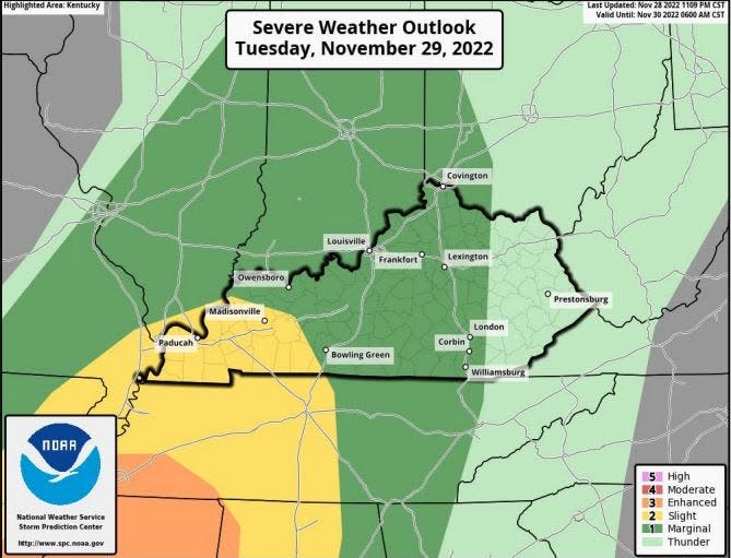
Thunderstorms are expected in Central and Western Kentucky and portions of Southern Indiana, according to a release from the National Weather Service in Louisville. The threat of strong to severe storms will be present from 6 p.m. Tuesday to 5 a.m. Wednesday, with the strongest threat in the Louisville area between 8 p.m. and 3 a.m.
"Damaging wind gusts" are the biggest threate, the release said, though "a low potential for hail and an isolated tornado exists."
As storms pass through, a cold front will move from west to east Wednesday, sending temperatures plummetting as we head into December. Tuesday's high is 65 degrees, but that's expected to drop to the lower 40s by Wednesday.
For Courier Journal subscribers:What's keeping LMPD's citizen oversight board from doing its job?
Here is the seven-day weather forecast for Louisville:
Tuesday, Nov. 29: High of 65 with a 20% chance of showers after 4 p.m.
Wednesday, Nov. 30: High of 41 with a 10% chance of thunderstorms before 7 a.m.
Thursday, Dec. 1: High of 42 with a calm wind.
Friday, Dec. 2: High of near 55. Partly sunny.
Saturday, Dec. 3: High near 56 with a 30% chance of showers.
Sunday, Dec. 4: High of 53 with a 60% chance of precipitation including rain and snow showers.
Monday, Dec. 5: High near 60 with a 60% chance of precipitation.
This article originally appeared on Louisville Courier Journal: Louisville weather: Thunderstorms, strong wind expected in Kentucky

