Powerful thunderstorms threaten central and eastern US with floods, hail and tornadoes
Powerful storms across the country threatened parts of the central and eastern United States with severe weather late Monday, bringing widespread risks of tornadoes, large hail, and strong winds.
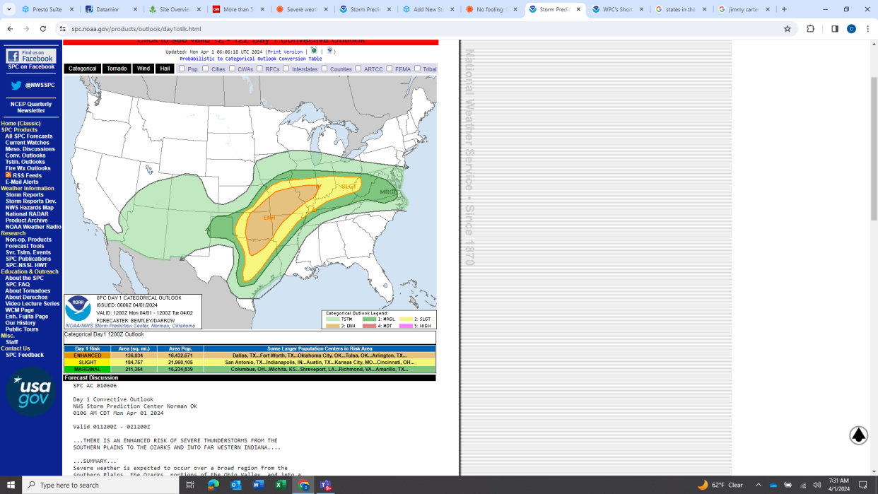
The storm system moved through Texas, Oklahoma, Missouri, and Illinois on Monday, where more than 9 million people were placed under severe thunderstorm watch, according to USA TODAY's weather alerts tracker. The storm was expected to dump potentially damaging hail, and cause fierce wind gusts up to 80 mph in some areas, the National Weather Service said.
At least three tornadoes were reported in Oklahoma on Monday evening, according to AccuWeather. Several tornado warnings were issued as a line of storms moved across the state.
Cities such as Oklahoma City; Tulsa, Oklahoma; and Wichita Falls, Texas, faced the largest threat of tornadoes. Portions of Oklahoma and Texas were placed under a "moderate" risk at level 4 on the weather service's 1 to 5 scale of severe storm severity.
Showers and thunderstorms were also expected Monday over parts of the mid-Atlantic region, hitting mainly Maryland, Virginia, and West Virginia, the weather service noted. Several inches of rain could batter localized areas. Urban spots, roadways, and small streams would be most vulnerable to flash flooding.
The severe weather threat will continue into Tuesday night, and extend from northern parts of Indiana and Ohio to the Chesapeake Bay region, according to AccuWeather.
Over the weekend, the system fueled storms that drenched Southern California, dropped tennis ball-size hail over parts of Illinois, and flooded low-lying areas throughout the Midwest.
11:30am CDT #SPC Day1 Outlook Moderate Risk: from extreme north TX into central/eastern OK https://t.co/TgJgC6cQZw pic.twitter.com/gaIta5oATh
— NWS Storm Prediction Center (@NWSSPC) April 1, 2024
High winds, large hail hit Texas
Hail as large as grapefruits or baseballs fell in parts of central Texas as wind gusts near 90 mph were reported in the state, AccuWeather said. A wind advisory was issued in portions of southwest and western Texas.
"Gusty winds may blow around unsecured objects," the weather service warned. "Winds this strong can make driving difficult."
The weather service urged motorists to use caution when driving in west Texas due to high winds and blowing dust that could reduce visibility to "as low as 1/2 mile as this front moves through."
Low visibility at an intersection south of Odessa and Midland, Texas, caused multiple accidents on Monday afternoon, according to the Upton County Sheriff's Department. The Texas Department of Public Safety said the accidents involved 30 cars and caused multiple injuries, CBS7 reported.
Tuesday may bring extreme weather east
The large system "will be quasi-stationary through Tuesday morning," which prompted the weather service to extend a moderate risk of storms for much of the state of Ohio. An enhanced risk of severe thunderstorms was in place for parts of the Midwest and Ohio Valley regions.
Beginning Tuesday morning and continuing throughout the day, the Ohio and Tennessee valleys as well as the central Gulf Coast states including Louisiana, Alabama and northern Florida – a vast area encompassing more than 50 million people – will be at risk of severe weather, according to the weather service.
"Wind damage and isolated large hail will be possible across a broad area," the weather service said. "The tornado threat is expected to be greatest from middle Tennessee north-northeastward into central and northern Kentucky."
Storm bringing snow, cold weather to Northeast later this week
The large storm system making its way across the country is threatening the Midwest and Northeast with an "all-out winter storm," according to AccuWeather.
Beginning Tuesday, snow is expected across parts of Wisconsin and Illinois before conditions intensify, and several inches of snow are expected in parts of Vermont, New Hampshire, and Maine, AccuWeather said.
Powerful wind gusts may snarl traffic and disrupt travel across the Atlantic Coast, AccuWeather said, adding that the combination of snow and wind is expected to last through Friday.
Rain damages section of Highway 1 in California, prompting closure
A section of Highway 1 in California remains closed because of a partial collapse of the road that occurred Saturday amid a storm that drenched a large area of Southern California in several inches of rain, according to the state's Department of Transportation.
The collapse was reported as heavy rain fell. By noon on Sunday, Caltrans crews were able to lead drivers through a single lane in the area, around the damaged section. The agency said on X on Sunday evening that the highway remained closed on the Big Sur Coast.
Though it didn't qualify as an atmospheric river because it lacks a strong link to tropical moisture, the area of low pressure that moved through Southern California represented a powerful final charge from the rainy season before the full-fledged transition to spring and the state’s dry months.
Contributing: Jorge L. Ortiz and Gabe Hauari
This article originally appeared on USA TODAY: Severe thunderstorms threaten central, eastern US with tornadoes, hail

