Gusty winds to create difficult travel in Southern California, southwestern US into midweek
As a potent storm slides across the interior West, gusty winds will create difficult travel for some motorists across Southern California and the southwestern United States in general into the middle of this week.
The circulation around the large storm that produced accumulating snow over part of the Great Basin and Rockies on Monday will continue to have an influence on the weather over the region during Tuesday and to some extent on Wednesday. As the storm departs and high pressure builds in to replace it, gusty winds will result.
Operators of high-profile vehicles such as commercial trucks, buses and recreational vehicles should keep a firm grip on the steering wheel and reduce their speed as necessary.
Pockets of blowing dust are likely in the desert areas, while freshly fallen snow can blow around from the mountains of California to Utah.
Minor airline delays are possible due to the gusty nature of the winds.
Isolated wind gusts can be strong enough to knock over weakly rooted trees and break tree limbs.
Two people were reportedly killed on Monday after a large tree toppled onto their home during strong northwest winds in Point Loma, California, according to Fox 5 San Diego.
Massive tree crushes house killing two people inside https://t.co/4uNPGECeRi pic.twitter.com/PW358RWm2q
— FOX 5 San Diego (@fox5sandiego) January 21, 2019
The strongest winds have already occurred. On Monday and into Monday night, gusts from the westn and northwest as high as 60 mph occurred.
Winds have switched around to the Northeast as of Tuesday. While winds but will shift from the southwest and west to northwest and north.
"Strong gusts can still occur over the passes, open areas of the high deserts and peaks of the ski resorts from Southern California to Nevada, Arizona and parts of Utah and New Mexico through Tuesday," according to AccuWeather Meteorologist Jake Sojda.
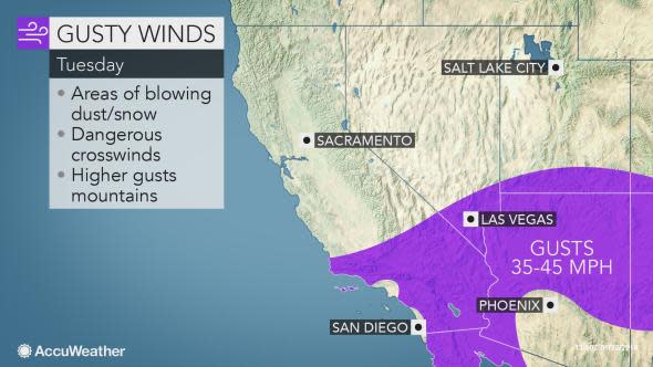
In the windiest spots, over the ridges and wide open places, gusts may reach 80 mph or so.
"The combination of gusty winds and the dry, chilly air will produce painful AccuWeather RealFeel® Temperatures over the interior Southwest and especially the mountains into midweek," Sojda said.
Wind winds now from the northeast, no more strong winds are forecast for Los Angeles for the week.
From Tuesday to Wednesday, winds are forecast to be like that of a weak to moderate Santa Ana. During this period, winds are likely to become less forceful overall, but they can still cause some problems.
As the winds line up in the east and northeast orientated canyons, a few gusts may range between 40 and 50 mph before diminishing Wednesday.
Since the area received a significant amount of rain in recent weeks, in some cases two to three times that of average for January, the risk of wildfire ignition and rapid spread is low.
The winds will help to dry out soggy areas and allow streams to continue to recede.
It may not be until early February, when another storm may come along to bring rain and significant mountain snow to the region.

