Significant flooding to follow episode of spring fever in East


A surge of springlike warmth will make it feel more like late March and early April across much of the eastern United States into Thursday night, but a potent storm will arrive and unleash drenching rain, melting snow and a snow-eating wind that AccuWeather meteorologists say will set into motion rapid runoff and flooding from the lower Great Lakes to the interior Northeast that can persist into Friday.
The same storm will produce heavy snow, a quick freeze-up and even blizzard conditions in parts of the Midwest while triggering severe weather in a portion of the Mississippi Valley into Thursday night.
As the storm tracks northeastward over the Central states, increasing southerly winds will pump warm air into the eastern third of the nation. Temperatures will climb into the 70s in Atlanta; Charlotte, North Carolina; Columbia, South Carolina; and Richmond, Virginia; on Thursday.
"We're calling it spring fever [on Thursday]. You're going to have that. No doubt about that," AccuWeather Chief On-Air Meteorologist Bernie Rayno said.
 |
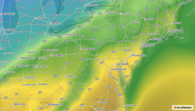
This image shows actual temperatures (F) as of 2 p.m. EST Thursday, Feb. 17, 2022. |
Farther north, temperatures reached the upper 60s in New York City. In Boston , the temperature tied the record of 61 set in 1981 by the early afternoon. In Philadelphia, temperatures were approaching the record of 68 set in 1976 as of the mid-afternoon hours. Temperatures may even touch 70 in Washington, D.C.
Increasing southerly winds may keep south-facing shoreline areas of the Atlantic Ocean and bays several degrees lower and will rapidly melt the remaining piles of snow leftover from recent storms.
"By Thursday night, the winds can really howl and become strong enough to lead to sporadic power outages and cause flooding at times of high tide," AccuWeather Senior Meteorologist Adam Douty said.
 |
The gusty winds will also pump the warm air over areas in and west of the Appalachians where a substantial amount of snow remains on the ground.
There is a broad area across the northern tier of the United States where the ground is still covered with snow. Snow cover ranges from a few inches to a foot in depth from northern Indiana and Ohio to northern Pennsylvania, much of upstate New York and New England. As much as 1 to 2 feet of snow is on the ground along the shores of lakes Erie and Ontario from northeastern Ohio to central New York and over the Adirondacks and Green and White Mountains farther to the east. Within that snow cover, there is up to a few inches of water locked up that could be released.
 |
The combination of the warm air and gusty winds will raise the temperature of the snowpack and set the stage for more rapid melting, especially as rain moves in just ahead of a press of colder air.
The storm over the Central states is expected to bring a general 1-2 inches of rain with localized areas of 2-4 inches of rain from portions of the Tennessee and Ohio valleys to the southern portion of the St. Lawrence Valley. This includes a large area of the country with deep snow cover.
 |
The combination of the heavy rain, gusty winds and mild, moist air will likely cause some or much of the snow to liquefy and run off into area streams and rivers and lead to flooding. The magnitude of that melting will hold the key to the scope of flooding.
Flooding may occur in and around cities like Indianapolis and Cleveland and Akron, Ohio. Farther to the east, Pittsburgh and Erie, Pennsylvania, Buffalo, Syracuse and Watertown, New York, and areas farther north like Burlington and Montpelier, Vermont, will be at risk for flooding as well.
"Many of the waterways in this same region of the interior Northeast and Midwest still have a substantial amount of ice on them and the rapid thaw, combined with heavy rain is likely to break up some of that ice," AccuWeather Senior Meteorologist Brett Anderson said, adding that, "There is the potential for ice jams to form and add to the flooding problems while potentially causing damage to property along the edges of the streams and rivers."
The flooding problems are likely to develop on Thursday in portions of the Midwest, from just south of the snowfall zone to parts of the Tennessee Valley. From there, issues will expand northeastward over the eastern Great Lakes region to the central and northern Appalachians, which includes areas with heavier snow cover, on Thursday night.
 |
The brevity of the thaw and rain may prevent a widespread, major flooding event and limit the problems to more of a moderate or localized nature in most of the region. However, along some stretches of small streams and rivers, major flooding may be unavoidable.
Since the storm itself is forecast to lift northward across Canada and an area of high pressure over the southern Atlantic coast may remain strong, the rain is likely to become abbreviated from much of the Carolinas to the mid-Atlantic and southeastern New England as a cold front accelerates eastward.
Still, downpours can be intense enough and accompanied by thunder and lightning to lead to brief urban flooding and travel disruptions from the central and southern Appalachians Thursday night to along the Interstate 95 corridor for part of the Friday morning rush hour. The strong winds from Thursday night into early Friday can cut power to some neighborhoods as trees topple and block some streets and secondary roads.
 |
"Just as quickly as temperatures surge across the region into Thursday evening, temperatures will crash from west to east from Thursday night to Friday in a classic case of weather whiplash," Rayno said.
As cold air sweeps in behind the front, it will cause wet and slushy areas to freeze across parts of the Midwest and interior Northeast. Icy travel is likely to develop, but at the same time, runoff will slow down and water levels on small streams should stabilize.
Waters may continue to rise on some of the larger rivers from portions of Indiana and Ohio to northwestern Pennsylvania, upstate New York and northern New England into the start of the weekend.
CLICK HERE FOR THE FREE ACCUWEATHER APP
Temperatures will slowly fall on Friday from the eastern Great Lakes to the Appalachians, but after a warm start to the day east of the mountains, temperatures are expected to nosedive during the midday and afternoon hours.
 |
In New York city, for example, the temperature is expected to be well into the 50s for morning rush hour, but will fall throughout the day, with afternoon temperatures ending up in the 30s.
Few, if any, problems due to river flooding are expected over much of the Southeast, mid-Atlantic and southeastern New England due to much less rain, little snow cover or a lack thereof, compared to areas centered around the eastern Great Lakes.
For the latest weather news check back on AccuWeather.com. Watch the AccuWeather Network on DIRECTV, Frontier, Spectrum, fuboTV, Philo, and Verizon Fios. AccuWeather Now is now available on your preferred streaming platform.
