Significant storm to bring rain, wind to East Coast, slowing early holiday travel

A period of relatively quiet weather in much of the East this week will end dramatically late this weekend and early next week, as AccuWeather forecasters are expecting a significant storm to move up the coast and bring more heavy rain and gusty winds to the region.
The storm will evolve from a system moving into the South to end the week, bringing flooding downpours and coastal flooding. After gathering steam from the warm waters of the Gulf of Mexico early this weekend, the storm will rocket up the East Coast on Sunday and Monday along a path that is typical of storms during the winter months but carrying an amount of moisture usually seen during the summer.
For millions, it will end up being a case of déjà vu. "This next storm coming up the Eastern Seaboard will have similar characteristics to the one that slammed the mid-Atlantic and Northeast with heavy rain and wind just days ago," said AccuWeather Senior Meteorologist Joe Lundberg.
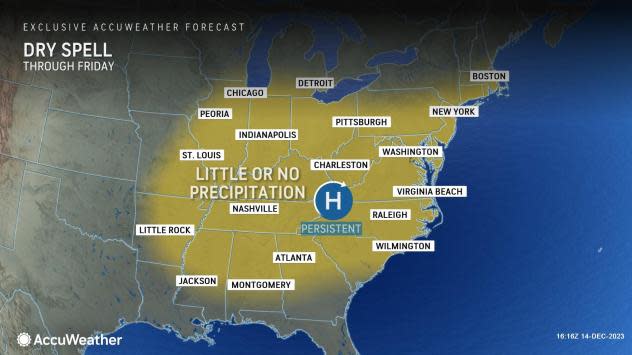
The period preceding the next storm is offering up one of the more prolonged stretches of quiet weather that the East has enjoyed in quite some time. The dry conditions have arrived courtesy of a sprawling area of high pressure from the Carolinas to New England which will be around until Saturday.
Amid sunshine, conditions will trend toward unseasonably mild through Saturday as the high pressure system moves off the coast and pumps in warmer air from the south.
 |
The trajectory of that high will be important in determining where the next storm can go and the impacts that it can bring. By moving off the East Coast rather than retreating to Canada, warmer air would flood the region from the south ahead of the storm Sunday, resulting in mainly rain rather than snow once precipitation arrives.
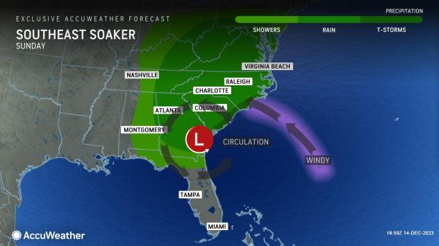
The high pressure system also will set up a gradient, or area of difference, with lower pressure in the Southeast, resulting in heavy rain, gusty winds and coastal hazards there into Sunday. At the same time, pieces of energy arriving from the Rockies and southern Plains will join forces over the warm Gulf of Mexico, causing a significant storm to take shape.
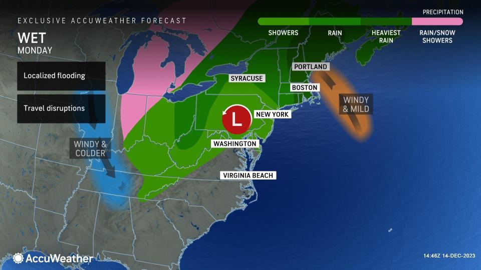
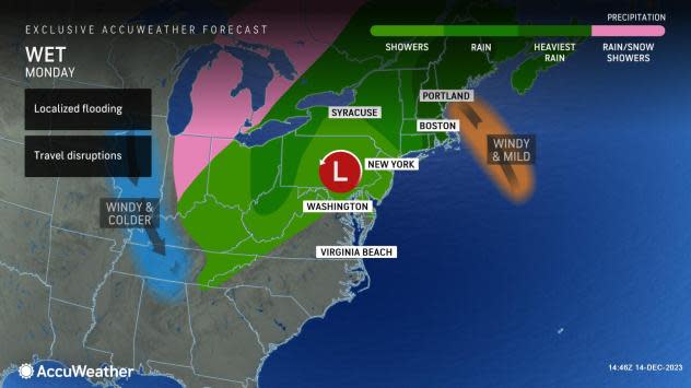
Almost exactly one week after the last storm moved through the mid-Atlantic and the Northeast, rain and gusty winds will return to these regions late this weekend and early next week, impacting residents and travelers in the region, warn AccuWeather meteorologists.
"While there remains some question in terms of the exact track and intensity of this storm, confidence is growing for a significant rain and wind event, especially from the Chesapeake Bay Area to most of southern New England," warned Lundberg.
 |
As the storm takes shape over the eastern Gulf of Mexico, Florida and portions of the Southeast will be first up for impacts ranging from heavy rain to severe thunderstorms to coastal flooding from Friday night to Saturday night.
Moisture from the storm will then surge up the East Coast beginning later in the weekend.
"Rain will spread across the mid-Atlantic by late Sunday then into New England Sunday night," said Lundberg. "It can fall heavy at times and lead to flooding, especially along and east of the I-95 corridor."
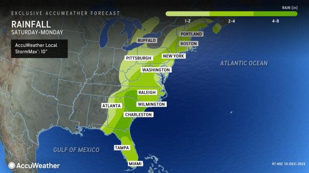
Lundberg added that the flooding concern has been elevated in the wake of the heavy rains from this past Sunday into Monday morning when 2 to 5 inches of rain was common from the Virginia tidewater region to eastern New England.
Locales from the Carolinas to the interior mid-Atlantic and the Delmarva Peninsula should experience the heaviest round of rain to end the weekend through Sunday night, resulting in rainfall totaling several inches. As the storm moves farther north, the downpours could dramatically impact commutes on Monday from the Philadelphia and New York Tri-State areas into New England.
"If the storm takes a track farther inland near the spine of the Appalachians, the upper Ohio Valley and eastern Great Lakes can also receive a steady, soaking rain with this event," AccuWeather Meteorologist Reneé Duff said.
 |
While the path factor of the storm will determine how far inland that the heavy rain can get, the intensity factor will determine how strong that the winds can be with the next storm. The odds of impacts from gusty winds for the coast will be high in most intensity scenarios.
"Strong winds are likely with the storm, particularly near the coast, which can lead to beach erosion and coastal flooding," added Lundberg.
 |
Unlike the last storm that brought up to a foot of snow to the interior Northeast, the winter weather aspect of this storm should be limited due to a lack of cold air. However, in the mountains of northern New England, including the Greens and Whites, rain may briefly mix with or change to snow with accumulations on the lighter side.
The storm can have wide-reaching impacts on travel from late this weekend into early next week, as we enter a busier stretch during the holiday season. Interstates including 20, 40, 64, 80, 81, 84 and 95 are among those that can be impacted. Ripple effects could also be felt at airports all across the country, with delays incurred at big hubs in Eastern cities like Atlanta, Boston, Charlotte, Pittsburgh and Washington, D.C.
 |
Those planning early travel before the Christmas holiday with the flexibility to wait until after the storm passes by next week may want to do so, say AccuWeather forecasters. In the immediate wake of the storm, a burst of chilly air and lake-enhanced snow showers can occur early next week. By the middle and end of the week, however, high pressure may again set up shop, bringing a much quieter weather pattern back to the East.
There is a small possibility that there will be cloudiness, lingering rainfall and perhaps some wintry weather across the mid-Atlantic Tuesday to Wednesday, but the expected impacts would be well below what is anticipated during the storm. This scenario would occur if the upcoming storm stalls for a time off the coast.
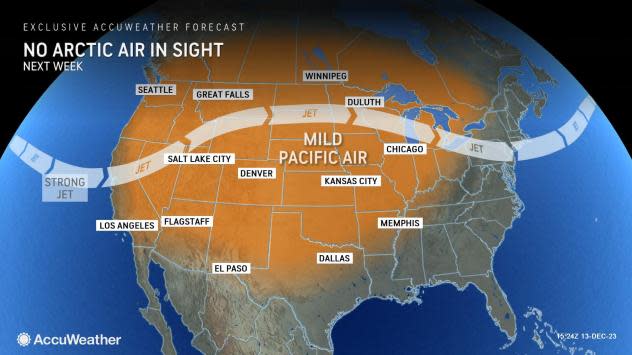
Accompanying the drying trend will be milder weather, as Pacific air streaming from west to east across the country will put a lid on the potential for intrusions of Arctic air or widespread snow events in the week before Christmas, potentially stunting the odds for a white Christmas for many.
Want next-level safety, ad-free? Unlock advanced, hyperlocal severe weather alerts when you subscribe to Premium+ on the AccuWeather app. AccuWeather Alerts™ are prompted by our expert meteorologists who monitor and analyze dangerous weather risks 24/7 to keep you and your family safer.
