Significant winter storm to bring near-blizzard conditions, bitter cold to West and Plains


The season's first widespread snowfall is on tap for portions of the Rockies and northern Plains this week, and it is expected to bring all the trappings of winter from heavy snow to gusty winds to bone-chilling cold, warn AccuWeather meteorologists.
The winter weather event, expected to unfold in waves through Friday and impact more than a half-dozen states, could lead to significant travel disruptions from locally more than a foot of snow. Strong winds generated by the storm will also reduce visibility at times, and bitter cold air in its wake could challenge long-standing record low temperatures.
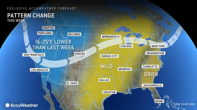
The snow and cold will represent a dramatic change in the weather pattern across the region compared to last week, when dry, near-record warm conditions were the norm.
 |
A pattern change across the West will lay the foundation for the disruptive winter storm this week.
As a cold front and atmospheric energy moves through, some snow will continue to fall across the higher elevations of the Northern Rockies on Tuesday, say AccuWeather meteorologists. This includes the mountains in northern Idaho and Montana.
This initial wave of precipitation will be the least disruptive of the two expected to unfold this week across the West and Plains, and is expected to fall as mainly rain from the Great Basin to the foothill grasslands of Montana. It will, however, begin to cause temperatures to tumble.
That change in temperature will be nothing short of shocking compared to last week. In Great Falls, Montana, temperatures which exceeded 80 degrees and set a record high last week will drop below freezing by Tuesday morning, and stay there for nearly a week, according to the AccuWeather forecast.
 |
The coldest air, straight from the Arctic regions, will arrive along with and behind the second, more significant wave of snow later in the week.
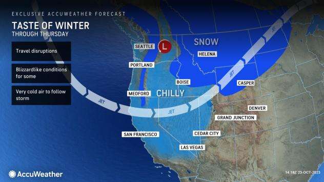
The snowstorm forecast to unfold later in the week will be nothing short of the first significant winter storm the nation has seen so far this season, say AccuWeather meteorologists.
"Time should be taken early this week to prepare by unpacking winter gear like shovels, coats, hats and gloves," said AccuWeather Meteorologist Joseph Bauer. "It can be a good idea to start up snow removal equipment like snowblowers to ensure they function properly."
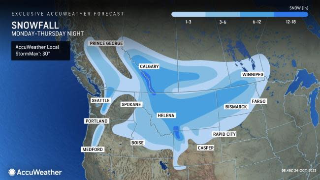
A second, more potent area of low pressure will move ashore in the Pacific Northwest on Tuesday, causing snow to break out again over the Washington Cascades into Tuesday night. Accumulations of 6-12 inches are forecast here into Wednesday, including at pass levels. Anytime there is the potential for accumulating snow over the passes, there is the risk that roads may close for a time.
Have the app? Unlock AccuWeather Alerts™ with Premium+
At the same time, snow will become more widespread across the northern Rockies by Tuesday night. "Most passes from the Washington Cascades to the northern Rockies can experience snowfall which can slow logistical operations," said Bauer.
Because temperatures along with and behind the snow will stay below freezing, accumulations can begin immediately on roadway and sidewalk surfaces, leading to slippery and icy conditions. Morning and evening commutes on Wednesday will be slow in cities such as Billings, Helena and Missoula, Montana.
The Oregon Cascades, and a wide area from northeastern Oregon across central and northern Idaho, Montana and northern Wyoming is forecast to receive 3-6 inches of snow from the storm.
A corridor encompassing the mountains of the Bitterroots, locations on southward around Yellowstone Park and the zone from northern and central Montana to northwest North Dakota can see the heftiest amounts from this storm: 6-12 inches, with localized amounts well above a foot. The AccuWeather Local StormMax™ in this rugged terrain is 30 inches.
 |
By Thursday, the snow is expected to expand south and east, into a portion of the central Rockies and Plains, as the storm moves east and strengthens. The drop in pressure from the strengthening storm will kick up the wind toward late week, adding another layer to the wintry weather.
"Gusty winds on Thursday can lead to blizzard-like conditions across the Dakotas, with blowing and drifting snow, along with reduced visibility," warned Bauer.
Such conditions could imperil motorists for a time later this week on portions of Interstates 29, 90 and 94 in the northern Plains. Several inches of snow can accumulate here, with drifts of well over a foot possible.
Complicating things will be some rain expected to fall on Tuesday and Wednesday in parts of the northern Plains ahead of a transition to snow. "As temperatures fall well below freezing later in the week, this can lead to freeze-up issues and slick spots on roads and highways," added Bauer.
While the colder air accompanying the snow will be enough to support accumulations on paved surfaces, the air mass following the storm will be even more frigid, warns AccuWeather.
 |
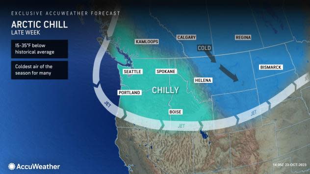
"In the wake of this storm, an Arctic air mass will usher in the coldest air of the season," said Bauer. "Temperature readings 15-35 degrees below the historical average can be expected in Montana and Wyoming by Thursday night."
For most in the northern Rockies, this bitter cold air mass could result in the first subzero readings of the season. For many more across the Northwest and northern Plains, low temperatures in the single digits and teens will be common by late week and into next weekend, the coldest readings since last spring.
Despite the sudden and sharp cold, however, record temperatures are rather low, and most are not likely to be broken during the outbreak of Arctic air.
These chilly conditions can linger into the following week, including for trick-or-treating on Halloween.
Want next-level safety, ad-free? Unlock advanced, hyperlocal severe weather alerts when you subscribe to Premium+ on the AccuWeather app. AccuWeather Alerts™ are prompted by our expert meteorologists who monitor and analyze dangerous weather risks 24/7 to keep you and your family safer.
