Sioux Falls area could get up to 2 inches of snow, blizzard warnings issued elsewhere
- Oops!Something went wrong.Please try again later.
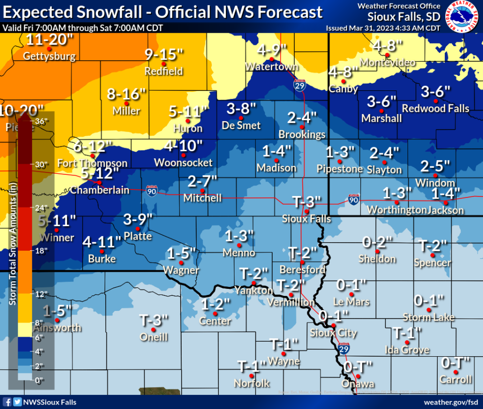
While much of South Dakota is under blizzard-like conditions heading into the weekend, the southeastern corner of the state will experience the less hazardous part of a winter storm as it moves through.
Lincoln and Minnehaha counties will be under a winter weather advisory from 4 p.m. Friday to 4 a.m. Saturday, according to the National Weather Service of Sioux Falls. Residents can expect up to 2 inches of snow and slight ice accumulation, along with mixed precipitation, the advisory states.
Meanwhile, toward the central part of the state and to the north, Gov. Kristi Noem has closed state offices in multiple counties Friday, where blizzard warnings are expected to last until about 4 a.m.
More: How to check South Dakota road conditions, see cameras as winter storms hit
State offices are closed in the following counties: Aurora, Beadle, Brown, Buffalo, Brule, Campbell, Charles Mix, Clark, Codington, Corson, Davison, Day, Deuel, Dewey, Douglas, Edmunds, Faulk, Grant, Gregory, Hamlin, Hand, Hughes, Hyde, Jerauld, Jones, Lyman, Marshall, Mellette, McPherson, Potter, Roberts, Sanborn, Spink, Stanley, Sully, Todd, Tripp and Walworth counties.
The warning asks drivers to restrict travel, and only do so if necessary. For information on road current conditions, check sd511.org.
National Weather Service forecast for Sioux Falls area this weekend
Saturday: Partly sunny, then gradually becoming sunny, with a high near 40. Breezy, with a north northwest wind 15 to 20 mph becoming west 5 to 10 mph in the afternoon. Winds could gust as high as 35 mph.
Saturday night: Increasing clouds, with a low around 33. Windy, with a south wind 10 to 20 mph increasing to 20 to 30 mph after midnight. Winds could gust as high as 40 mph.
Sunday: Mostly cloudy, then gradually becoming sunny, with a high near 51. Breezy, with a south wind 20 to 25 mph becoming west northwest in the afternoon. Winds could gust as high as 35 mph.
Sunday night: Partly cloudy, with a low around 32. West northwest wind 5 to 15 mph, with gusts as high as 25 mph.
Monday: Partly sunny, with a high near 46.
Monday night: A chance of snow after 2 a.m. Mostly cloudy, with a low around 31. Blustery. Chance of precipitation is 50%.
Tuesday: Snow likely, mainly after 8 a.m. Mostly cloudy, with a high near 39. Breezy. Chance of precipitation is 70%.
Tuesday night: Snow likely. Mostly cloudy, with a low around 23. Blustery. Chance of precipitation is 70%.
Wednesday: Snow likely. Mostly cloudy, with a high near 30. Blustery. Chance of precipitation is 60%.
This article originally appeared on Sioux Falls Argus Leader: Sioux Falls under winter weather advisory, blizzard warning in other counties

