Six ‘water tornadoes’ spotted in Gulf of Mexico as tropical storms approach US mainland
Six water sprouts were spotted swirling simultaneously in the Gulf of Mexico last week, as two tropical storms headed for the US mainland.
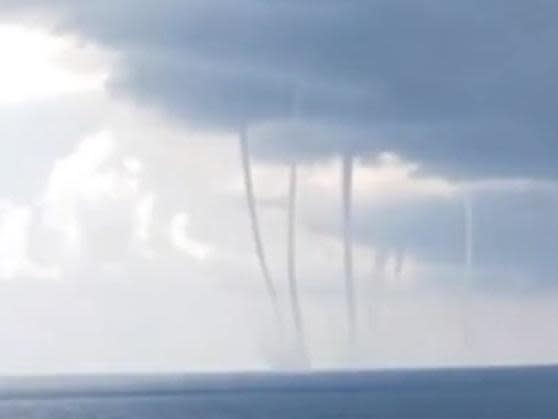
Video captured by Frank Leday shows towering columns of seawater being sucked into the air off the coast of Louisiana.
“Wow!! Ever see 6 water spouts at once?” Mr Leday wrote on Facebook.
Water sprouts are tornadoes that form over water, or move from land to water, according to the National Ocean Service.
The watery vortexes have the same characteristics as a regular tornado, usually occur during storms and can be just as dangerous as regular tornadoes.
Mr Leday caught sight of the phenomenon as two tropical storms brewed off the coast of the US and hailstones in Louisiana.
After a day as a hurricane, Storm Marco brought a surge of high water to the Louisiana coast on Monday, setting the stage for Tropical Storm Laura to enter the Gulf of Mexico and move towards the same stretch of US coast later in the week, most likely as a hurricane.
People along the Gulf Coast braced for an onslaught from the twin storms, with many evacuees recalling the damage caused by Hurricane Katrina in 2005, when catastrophic flooding breached the levees in New Orleans and as many as 1,800 people died.
“What we know is there’s going to be storm surge from Marco, we know that that water is not going to recede hardly at all before Laura hits, and so we’ve not seen this before and that’s why people need to be paying particular attention,” Governor John Bel Edwards warned at a Sunday briefing.
Marco had grown into a hurricane early Sunday, and while its top winds dropped to 50 mph on Monday morning, the National Hurricane Center cautioned that Marco could still cause life-threatening storm surges and dangerous winds along the Gulf Coast. Marco was centred about 85 miles (135 kilometres) south-southeast of the mouth of the Mississippi River Monday morning, moving northwest at 10 mph (17 kph).
Forecasters said it would likely remain just off the Louisiana coast through Tuesday.
Laura’s centre was skirting Cuba’s southern coast on Monday after causing the deaths of at least 11 people in the Dominican Republic and Haiti, while knocking out power and causing flooding in the two nations that share the island of Hispaniola.
It had top sustained winds of 65 mph (100 kmh) and its eye was forecast to remain over water, bringing tropical storm conditions to much of Cuba before moving into the southeastern Gulf of Mexico Tuesday, where it was expected to strengthen into a hurricane before approaching the Louisiana coast on Wednesday.
Haitian civil protection officials said they had received reports a 10-year-old girl was killed when a tree fell on a home in the southern coastal town of Anse-a-Pitres, on the border with the Dominican Republic. Haiti’s prime minister said at least eight other people died and two were missing. In the Dominican Republic, relatives told reporters a collapsed wall killed a mother and her young son.
Hundreds of thousands were without power in the Dominican Republic amid heavy flooding in both countries.
Despite Marco’s weakening, a storm surge warning remained in place from Morgan City, Louisiana, to Ocean Springs, Mississippi. A tropical storm warning included Lake Pontchartrain in Louisiana and metropolitan New Orleans.
A storm surge of up to 4 feet (1.2 meters) was forecast for parts of coastal Louisiana and Mississippi.
Additional reporting by agencies
Read more
Double hurricane threat as two tropical storms advance towards US

