SLO County supervisors adopt new district map on 3-2 vote. Here’s what it looks like
The San Luis Obispo County Board of Supervisors selected a new district map on Tuesday.
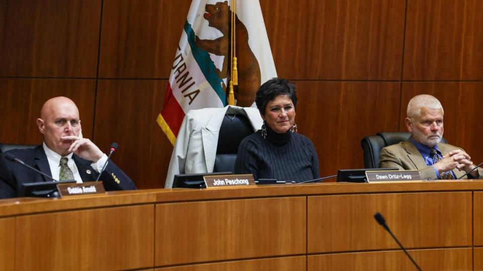
The board voted 3-2 to select Map A, designed by the firm Redistricting Partners, to replace the so-called Patten map.
“We need a fair and equitable map that does not favor a particular political party, and that ensures that all county citizens have a voice in our democracy,” Supervisor Jimmy Paulding said at Tuesday’s board meeting.
The board’s decision comes after supervisors voted on March 21 to settle a lawsuit with local group San Luis Obispo County Citizens for Good Government, agreeing to throw out the Patten map and pick a new map by May 15.
SLO County Citizens for Good Government sued the county over the map in 2022, arguing that it split up communities of interest and advantaged Republican voters.
The League of Women Voters of San Luis Obispo County later joined the lawsuit, along with some individuals.
On Tuesday, supervisors Bruce Gibson, Dawn Ortiz-Legg and Paulding, who agreed with the claims in the lawsuit, voted to remove the Patten map and select Map A as its replacement.
The three supervisors agreed that Los Osos, Morro Bay, Cambria and Cayucos should be in the same district, as they share environmental and economic interests tied to the coast. They also said that Oceano and Nipomo should be paired together, too, as they share the Oceano Dunes, agricultural interests and a large Latino population.
Map A achieves these goals, while maintaining boundaries similar to the 2011 map, Gibson said.
“It does represent minimal change,” Gibson said.
The trio noted that the lawsuit was a grassroots effort sparked by outrage with the way the previous board selected the map.
“The reason we’re here is there was a movement in our community … a movement around democracy and transparency, accountability and good governance,” Paulding said.
Supervisors John Peschong and Debbie Arnold, however, did not think that the Patten map violated the Fair Maps Act, as the lawsuit claimed, and voted against establishing a new district map.
Because the board voted to settle the lawsuit, no judge could determine whether or not the Patten map violated the act, the pair said.
“There is no gerrymandering because the court did not rule that there’s any gerrymandering,” Peschong said.
Arnold would have preferred that the board allow the lawsuit to play out in court, she said.
“To have a legally elected board, in the legal time frame, adopt a legally compliant map, following the process every step of the way ... to have it end with a settlement done by a few people behind closed doors is a really sad thing,” Arnold said.
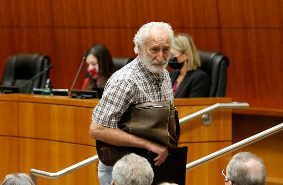
Richard Patten, the Arroyo Grande resident who submitted his map in 2021, also criticized the change, equating the new majority on the Board of Supervisors to a “ Venezuelan democracy.”
How does Map A compare to other district maps?
Patten submitted his map to be considered during the county’s redistricting process, which occurs every 10 years.
Three conservative supervisors — Peschong, Arnold and Lynn Compton — voted to adopt the Patten map, while supervisors Dawn Ortiz-Legg and Bruce Gibson opposed.
Patten’s reshuffling of the districts ended with a conservative-leaning map, despite the county having more registered Democrats than Republicans.
For example, the liberal-leaning town of Oceano moved from District 4 to District 5, leaving District 4 with more conservative voters.
Edna Valley and the San Luis Obispo Country Club area also moved into District 4, adding more registered Republicans to the area.
District 2, formerly a coastal district stretching from Los Osos to the top of the county, also changed.
Under the Patten map, liberal-leaning Morro Bay and Los Osos were parceled out to other districts, while Atascadero — a more conservative inland city — moved into District 2.
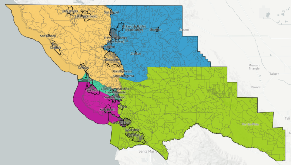
According to a 2021 analysis done by The Tribune, the Patten map favored Republican voters by packing Democrats into Districts 2 and 5 — making it easier for Republican candidates to win Districts 1, 3 and 4 and maintain a conservative majority on the board.
Despite that advantage, however, conservatives still lost their majority when Gibson beat challenge Bruce Jones in November by 13 votes to take the reconfigured District 2 seat.
The board reviewed three possible maps on Tuesday to replace the Patten map — one designed by the San Luis Obispo Chamber of Commerce, and two drawn by the firm Redistricting Partners. In 2021, the board considered these three maps alongside the Patten map.
“These aren’t maps that just came out of nowhere,” Redistricting Partners representative Paul Mitchell said at Tuesday’s board meeting.
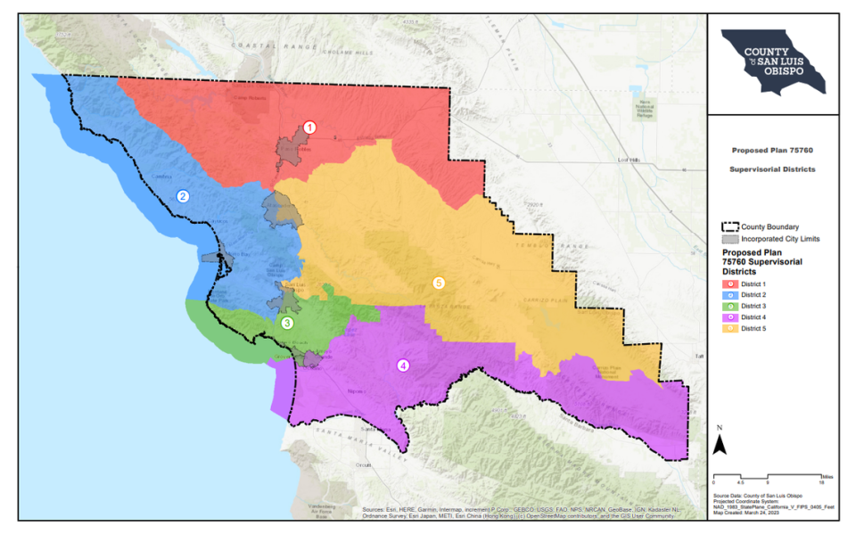
Map A preserves the boundaries of the 2011 district map with slight differences to accommodate for population changes revealed by the 2020 U.S. Census, Mitchell said.
This means that the coastal communities of Los Osos, Morro Bay, Cambria and Cayucos are reunited in District 2, while Oceano and Nipomo are reunited in District 4, according to Mitchell.
The map also returns Atascadero to District 5, and groups Santa Margarita with the Garden Farms community in the same district.
The population deviation between districts for Map A is 9.3%, Mitchell said.
This is more significant than the Patten map, which has a population deviation of 7.5%, according to Mitchell.
“I wouldn’t suggest that you weigh this difference between 7.5% and 9.3% as being a big deal,” Mitchell said.
As long as the population deviation is below 10%, the U.S. Supreme Court and state law consider the map legal and “reasonably compact,” Mitchell said.
Map B, also drawn by Redistricting Partners, is similar to Map A in mimicking the boundaries of the 2011 map.
A key difference is that Map B condenses Cal Poly into District 2, while Map A splits the university into more than one district, Mitchell said.
Map B’s population deviation matches the Patten map at 7.5%, Mitchell said.
Finally, the map proposed by the Chamber of Commerce deviates slightly from the 2011 district map.
“The chamber map keeps the cores of current districts largely intact, making some changes,” the staff report said.
In the chamber map, District 2 includes the northern coastal communities of Cambria, Cayucos, Los Osos, Morro Bay and San Simeon— along with a western portion of Atascadero that isn’t included in the 2011 map’s District 2 boundaries, according to the staff report.
The chamber map’s population deviation is slightly higher than the Patten map at 7.8%, the staff report said.
What does the Fair Maps Act require?
Any map the board selects must comply with California’s Fair Maps Act, and Mitchell confirmed at the meeting that all three maps did so.
The Fair Maps Act requires the map to follow numerous rules, including that districts are relatively equal in population size and that they are easily identifiable — meaning they follow city and natural boundaries and “keep districts compact, based on where people live” — along with keeping communities of interest intact, Mitchell said at the meeting.
Communities of interest are a group of people with similar needs and interests. A community of interest could be a neighborhood or a city, but it can also be an area where there’s a concentrated group of senior citizens, or where people have similar environmental concerns, Mitchell said.
The important question is, “How do these lines empower communities of interest?” Mitchell said.
The Fair Maps Act requires that the county hold four public hearings to discuss the map, including one hearing on the weekend and another after 6 p.m. on a weekday.
Neal explained that the current redistricting process is a continuation of the January 2021 redistricting process when the board selected the Patten map.
As a result, the county has met its requirements for hearings, County Counsel Rita Neal said.
Though the California Election Code and Fair Maps Act ban the county from adopting a map specifically to advantage or disadvantage a political party, it doesn’t prevent the board or other parties from reviewing partisan data along with other data, Neal said.
“What the code says is that you can’t adopt a man for the purpose of favoring or discriminating against a political party,” Neal said. “It doesn’t give any direction on how the board is supposed to consider that.”
A court later determined that the board should have considered partisan data once it was submitted to the record, Neal said.
Which map do community members prefer?
Speaking at Tuesday’s meeting, SLO County Diversity Coalition Executive Director Rita Casaverde said she wants Garden Farms to be included in the same district as Santa Margarita, the town’s “natural neighbor.”
“Every Halloween all the kids go from Garden Farms to trick-or-treat in Santa Margarita,” said Casaverde, who lives in Garden Farms. “Santa Margarita is where our nearest public library is, where our nearest public church is, so it’s really nice to know that our communities will be coming back together.”
“I really thank all of you for bringing some sense of fairness back to the process,” Casaverde told the supervisors.
Lifetime Oceano resident Allene Villa also expressed support for Map A, because it reunites her town with Nipomo. The two South County communities share a large Latinx population and agricultural economy, along with tourism related to Oceano Dunes State Vehicular Recreation Area, she said.
“Latinos have settled in Nipomo and Oceano ... to pick the crops in the nearby fields,” Villa said. “The crops that they pick contribute significantly to the agriculture industry of our county and our district’s way of life.”
Atascadero resident Jim Patterson, a former county supervisor, said that it’s important to limit change when picking a new district map.
Map A returns “sanity, consistency, and fairness to the district boundaries in San Luis Obispo,” he said.
Other community members who spoke at Tuesday’s meeting wanted the board to stick with the Patten map because it puts Cal Poly and the city of San Luis Obispo in the same district, District 3.
Bruce Jones, who ran in the District 2 supervisors race in 2022, criticized Map A for connecting Cal Poly with northern rural communities in District 5 “through a narrow ribbon of land over the Grade and swooping down to collect a group of voters.”
Templeton resident Nancy Shaw argued that the city of SLO has different political interests than surrounding communities, and should reside in its own district.
“Why should three other districts become infected with the tentacles and votes of San Luis Obispo?” Shaw asked. “This is a big tell of gerrymandering unfairness and possibly illegal maneuvers.”
Patten himself said he submitted his map as a citizen, and the board adopted the map using a legal process.
“My map used no political data in its boundaries,” Patten said. “All of the community of interests were kept intact.”
He criticized the new board majority for settling the lawsuit and throwing out his map.
“The form of government that is called is kinda like a Venezuelan democracy,” Patten said.
Will SLO County still have ‘orphaned communities’?
SLO County supervisors will continue to serve in the districts to which they were elected until their next election, according to Neal.
This means that the Board of Supervisors will be working with three district maps until the 2024 election: the 2011 map, the Patten map and the newly adopted Map A.
Supervisors in District 1 and 5 will continue to serve under the 2011 map, Neal said.
During the 2024 election, the county will implement new boundaries for Districts 1, 3 and 5 as decided by Map A.
Districts 2 and 4 will keep their Patten map boundaries until the 2026 election, which will use Map A.
Using three maps will cause some hiccups in representation across the county.
For example, Atascadero voted for a District 2 supervisor during the 2022 election, and will have the chance to vote for a District 5 supervisor in 2024 under the newly adopted Map A — so those voters will technically have two elected supervisors until the 2026 election.
On the other hand, Los Osos didn’t get to vote for a supervisor in 2022, and won’t have the chance to vote again until 2026.
Los Osos resident Don Maruska, a plaintiff in the redistricting lawsuit, noted that the redistricting process turned neighbors against each other.
“We’ve somehow lost faith in each other, somehow lost the sense that we can just trust each other, to be considerate of one another’s needs and concerns and find solutions as a community of the county as a whole,” Maruska said.
He invited community members to set aside their differences, accept Map A and collaborate to solve other issues in the county.
“Now we have a choice,” Maruska said. “We can wallow in our many losses and grudges, or we can pivot from this moment of conflict.”

