SLO County supervisors will pick a new district map after settling lawsuit. What to expect
After reaching a settlement with local groups that sued San Luis Obispo County over redistricting, the county Board of Supervisors faces its next task: choosing a new district map.
On March 21, the board voted to approve a settlement agreement in the lawsuit filed by San Luis Obispo County Citizens for Good Government and joined by the League of Women’s Voters and other individuals.
The agreement directs the county to throw out the so-called Patten map and select a new map by May 15, according to county counsel Rita Neal.
The county spent $345,367 on legal fees for the case, and paid $300,000 to SLO County Citizens for Good Government as part of the settlement to cover that group’s legal expenses, Neal told The Tribune.
Here’s everything you need to know about the district map selection process.
What is the Patten map?
San Luis Obispo County is divided into five districts, each of which is represented by a member of the Board of Supervisors. The district boundaries are redrawn every 10 years based on population changes revealed by the U.S. Census.
In 2021, the board voted 3-2 to adopt a district map drawn by Arroyo Grande resident Richard Patten.
According to a 2021 analysis done by The Tribune, the Patten map favors Republican voters by packing Democrats into Districts 2 and 5 — making it easier for Republican candidates to win Districts 1, 3 and 4 and maintain a conservative majority on the board.
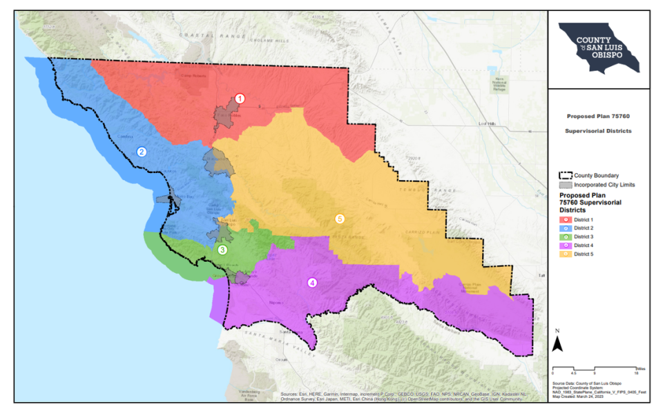
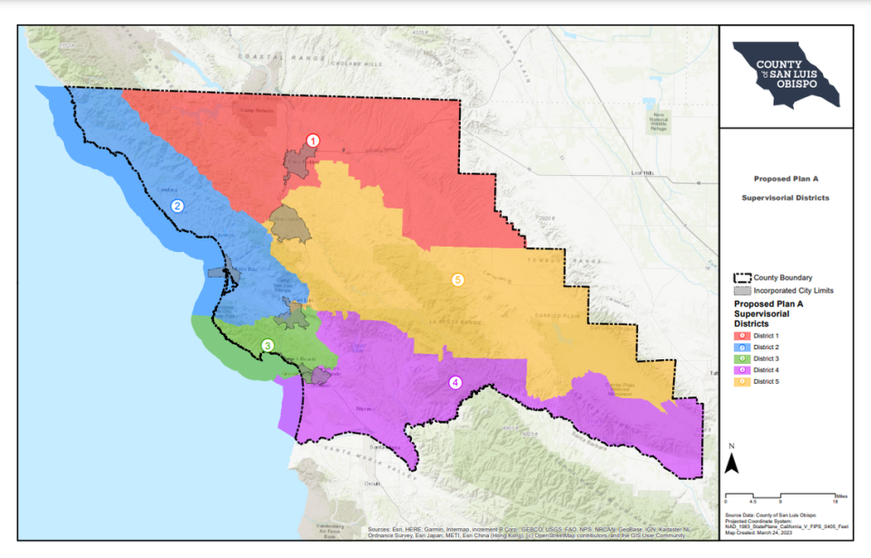
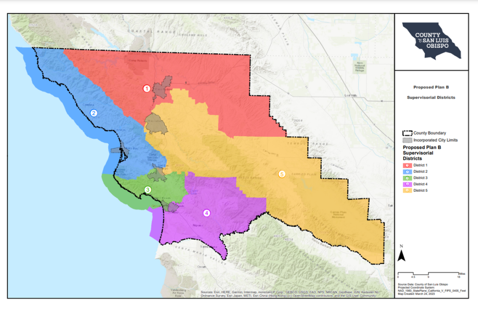
SLO County supervisors to look at 3 district maps
On April 4, county staff will introduce three ordinances to the board.
Each ordinance repeals the Patten map, and presents one of three possible maps — one designed by the San Luis Obispo Chamber of Commerce, and two drawn by the firm Redistricting Partners.
In 2021, the board considered these three maps alongside the Patten map.
At the April 4 meeting, the board will vote to set a date for a public hearing to discuss the three ordinances, which will likely be April 18, according to a county news release.
Community members can share their thoughts about the maps with the board at both hearings.
On April 18, the board could vote to select one of the three maps to replace the Patten map, or it could ask the county to come up with an entirely new map, Neal said.
“Whether they will (ask for a new map) or not, I don’t know,” Neal said.
Asking for a new map would “prolong the process,” Neal said. “If they did that, we’d have to reset a hearing and propose a new ordinance and go through the process again.”
What does Fair Maps Act require?
Any map the board selects must comply with California’s Fair Maps Act, according to Neal.
The California Elections Codes requires the district map to follow numerous rules, including establishing “substantially equal” populations in each district and keeping communities of interest intact.
A community of interest is “a population that shares common social or economic interests,” the code says. This doesn’t include political parties.
In addition, the election code says, the board should not “adopt supervisorial district boundaries for the purpose of favoring or discriminating against a political party.”

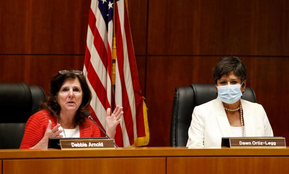
During the 2021 redistricting hearings, the board’s conservative majority — supervisors John Peschong, Debbie Arnold and Lynn Compton — refused to examine any data that showed the political makeup of each district.
Peschong and Arnold argued that the Fair Maps Act prohibited the board from reviewing partisan data when considering district boundaries.
There is no language in the law that prohibits reviewing partisan data, The Tribune reported in 2021.
The Fair Maps Act prevents the board from adopting a map to advantage or disadvantage one political party, but it doesn’t prevent the board from reviewing partisan data along with other data, according to Neal.
“(Partisan data) is one of many factors to adopt a map, just like the communities of interest, just like geographic continuity,” Neal said.
A court said that “once that partisan information was submitted into the record ... the board had an obligation to look at the information,” Neal said.
“Every time you move a (district boundary) line, there’s a counter to that,” Neal explained. “Maybe you move a line to keep the city intact, and that breaks up a community of interest. So the board just has to make findings in order to justify why they adopted a particular map, and the ideas have to be consistent with the Fair Maps Act.”
Who will represent local districts?
SLO County supervisors will continue to serve in the districts to which they were elected until their next election, according to Neal.
This means that the Board of Supervisors will be working with three district maps until the 2024 election: the 2010 map, the Patten map and the map adopted in 2023.
Supervisors in District 1 and 5 will continue to serve under the 2010 map, Neal said. During the 2024 election, the county will implement new boundaries for Districts 1, 3 and 5 decided by the newly adopted map.
Districts 2 and 4 will keep their Patten map boundaries until the 2026 election, which will use the newly adopted map.
Using three maps will cause some hiccups in representation across the county.
For example, Atascadero voted for a District 2 supervisor during the 2022 election, and may have the chance to vote for a District 5 supervisor in 2024 depending on the map the board chooses —so those voters will technically have two elected supervisors until the 2026 election.
On the other hand, Los Osos didn’t get to vote for a supervisor in 2022, and won’t get to until 2026.
“We will have some communities that don’t have a designated representative, and we will have some communities, like we do now, that have two supervisors that they voted for,” Neal said.
In January, the board addressed so-called “orphaned districts” by assigning supervisors to represent those areas. The board assigned Supervisor Jimmy Paulding to Oceano, and Supervisor Bruce Gibson to Los Osos and Morro Bay.
The board could take similar action after they chose a new map, Neal said, noting that the each supervisor is expected to represent the whole county — not just residents in their district.
“It’s going to be a matter of helping the public understand which district they are in and when they will be voting,” Neal said.
Why did SLO County settle the case?
After supervisors Bruce Gibson, Dawn Ortiz-Legg and Jimmy Paulding were sworn in to office in January, the attorney for SLO County Citizens for Good Government approached the county “to resolve the litigation,” Neal said.
During settlement discussions, the board considered San Luis Obispo Superior Court Judge Rita Federman’s 2022 ruling on the case.
That February, Federman ruled that the county could use the map for the 2022 midterm election to avoid disrupting the San Luis Obispo County clerk-recorder’s ability to prepare for the election.
However, Federman said that the group might be able to prove that the board “did not proceed in the manner required by law when it failed to consider evidence that the adopted map favored or discriminated against a political party.”
“The trial could have gone either way, and so the board felt that there was an opportunity to resolve it, to come up with a new adopted map that addressed concerns that the public had,” Neal said. “And we could stop spending money on attorney fees.”

