Snow accumulation possible later in week for southeastern South Dakota, NWS says
Sioux Falls has yet to experience a snow accumulation of more than an inch this season. By Friday, totals could change, according to the National Weather Service in Sioux Falls.
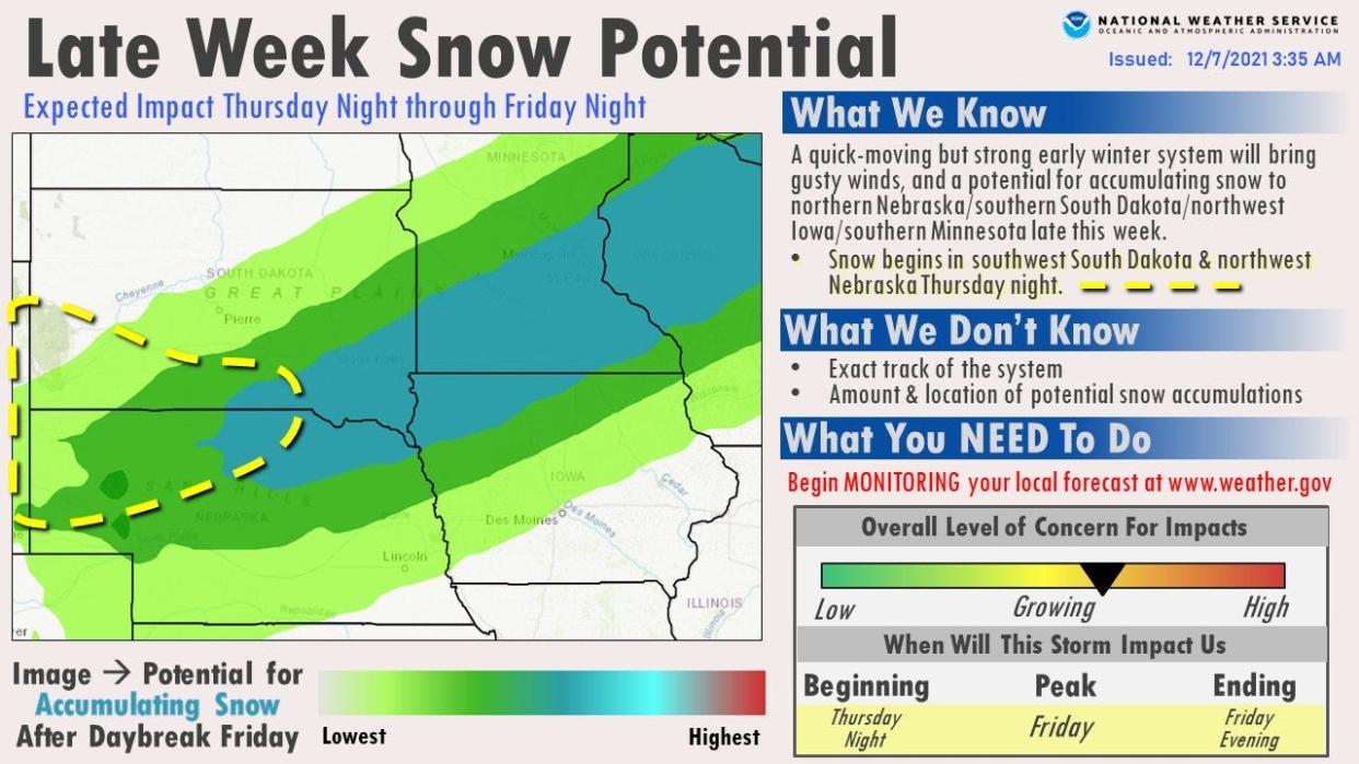
Thursday night and Friday could see accumulating snowfall, as of a Tuesday morning prediction of potential by the NWS for the northern Plains.
Regarding the exact track and resulting snowfall amounts, no measure is exact.
What's the forecast?
An early winter system is forecast to move into southeastern South Dakota around Thursday afternoon, bringing with it strong gusts of wind and a potential for snow, according to the NWS.
How much snow is possible?
The short answer is: it's too early to tell.
The NWS still doesn't forecast an exact location or snowfall accumulation predictions for certain areas. In general, the region of southwestern South Dakota could see snowfall starting Thursday into Friday.
Friday's forecast now is less than a half-inch, but the total could change.
Accumulation is likely to happen later, as possible meaningful snowfall in southeastern South Dakota would probably happen on Friday, according to the NWS.
More: Snowy McSnow Plow, Plowmagedon: Naming contest for South Dakota snow plows opens
What do the next few days look like in Sioux Falls?
Tonight: Partly cloudy, with a low around 12 degrees Fahrenheit. North-northwest wind around 5 mph turns calm in the evening.
Wednesday: Mostly sunny, with a high near 35 degrees. Light south wind shifting south-southeast 10 to 15 mph in the morning.
Wednesday Night: Mostly cloudy, with a steady temperature around 31 degrees. South southeast wind 10 to 15 mph, with gusts as high as 25 mph.
Thursday: Mostly sunny, with a high near 44 degrees. South winds of 5 to 10 mph to the northwest in the afternoon.
Thursday Night: A slight chance of snow after 1 a.m. Increasing clouds, with a low around 24 degrees. North northwest wind around 5 mph becoming northeast after midnight. Chance of precipitation is 20%.
Friday: Snow likely after 7 a.m. Cloudy, with a high near 33 degrees. Chance of precipitation is 70%. New snow accumulation of less than a half inch possible.
Friday Night: Snow likely, mainly before 7 p.m. Mostly cloudy, with a low around 16. Chance of precipitation is 70%.
Saturday: Sunny, with a high near 29 degrees.
Saturday Night: Mostly clear, with a low around 16 degrees.
Sunday: Sunny, with a high near 41 degrees.
Sunday Night: Mostly clear, with a low around 20 degrees.
Monday: Sunny, with a high near 39 degrees.
More: New Giliberto's Mexican Taco Shop location opens in former Wendy's location in Sioux Falls
Got a story idea from your community? Email reporter Alfonzo Galvan at agalvan@argusleader.com or follow on Twitter at @GalvanReports.
This article originally appeared on Sioux Falls Argus Leader: Winter system could bring snow to southeastern South Dakota on Friday

