Snow to blanket Hudson Valley this weekend as storm smashes Northeast
A nor'easter is creeping up the coast with its eye on smashing the Northeast with snow this weekend, and the Hudson Valley will see its share of havoc as a result.
The storm is expected to develop into a bomb cyclone that could be one for the record books in parts of New England, according to AccuWeather. What does that mean for New York? The region could be spared the worst of the storm's impact, but whether it veers a few dozen miles east or west will determine how severe it will be in the Hudson Valley.
Here's what you need to know as the area braces for the snow.
When will the snow start?
Flurries started falling in parts of the Hudson Valley on Friday morning, but that was not the start of the big storm, which is expected to begin late Friday night.
"I think the closer we get to midnight tonight the more likely it's going to be snowing steadily," AccuWeather meteorologist Tom Kines said Friday morning. "I suspect if you have to do errands this evening you're probably fine. But I think once we start getting past 7 o'clock, you've got to start being more concerned about steadier snows moving in, and certainly by 10 or 11 o'clock tonight."
Kines said the worst of the storm will probably occur between midnight and noon Saturday.
Bomb cyclone: What is it? Find an explanation here
Snow: How much will New York get on Friday and Saturday?
Weekend: Where to skate, check out an ice castle this weekend
The National Weather Service has issued a winter storm warning from 7 p.m. Friday until 7 p.m. Saturday in Westchester, Rockland and Putnam counties, and a coastal flood statement from 6 a.m. until 10 a.m. Saturday in southern Westchester.
A winter weather advisory will be in effect for Dutchess from late Friday night until late Saturday night and in Orange from 7 p.m. Friday until 7 p.m. Saturday.
"With the snow comes a lot of wind, as well, especially later on tonight and during the day tomorrow and even into tomorrow night," Kines said, noting some areas could see wind of 50 to 60 mph. "So whatever snow is falling will be blowing around. There will be a lot of blowing and drifting of snow. Whiteout conditions.
"If you have the option tomorrow of not traveling, I would definitely stay put. I don't think anything good comes out of trying to travel tomorrow."
How much snow will fall?
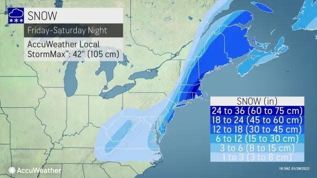
The most snow is expected to fall near the coast, with less snow as you travel north or west of New York City.
Kines said there are is a wide range of snowfall projections over the course of about a hundred miles, with Long Island potentially seeing 18 inches and the Catskills seeing an inch or two.
White Plains in Westchester is likely to get 8 to 12 inches, he said, with less accumulation as you move north and west.
The National Weather Service predicts 5.8 inches for New City in Rockland, 4.9 inches in Cold Spring in Putnam, 3.6 inches in Poughkeepsie in Dutchess, 3.3 in Middletown in Orange and 2.5 in Kingston in Ulster.
Power outage potential
Local utility companies are preparing for the possibility of power outages throughout the region as strong winds pair with the piles of snow on the way.
"There’s a very high degree of uncertainty with this storm, so we’re monitoring the conditions and the track of the weather system closely," said Joseph Jenkins, a spokesman for Central Hudson, whose territory includes Dutchess, Putnam, Orange, Sullivan and Ulster. "If we do get the heavier snowfall totals and stronger wind gusts, we’ll have a full complement of internal line and tree workers who will be ready to respond if outages occur."
NYSEG — whose service territory includes Westchester, Putnam, Dutchess, Orange, Sullivan and Ulster — said it does not anticipate any major outages, with "minimal impacts' on its Brewster, Liberty and Mechanicville divisions.
Still, "NYSEG urges customers to monitor local forecasts and prepare for the possibility of service interruptions, as heavy snow and high winds have the potential to bring down trees and limbs, causing damage to overhead power lines and other electrical equipment.
"In preparation for the event, the companies have pre-staged line and tree personnel, damage assessors and wire guards across the region to assist with restoration efforts if needed. Company and contractor crews will be onsite and prepared to facilitate an effective and efficient response should outages occur."
Con Edison and Orange & Rockland said they are monitoring the storm and will be ready to respond to outages. They emphasized that people should stay away from any downed wires, which may be live.
Highway departments have been preparing for slick road conditions, but officials are urging people to avoid driving.
"Despite our preparations we are asking residents to please stay off the roads if possible and to travel with extreme caution if you must travel," Rockland County Executive Ed Day said in a statement. "Give any plows you see on the road the space they need to do their jobs safely."
Post-storm weather
All that snow that piles up might not last too long.
Sunday is expected to be sunny, with temperatures peaking in the mid-20s, but temperatures are projected to rise to the low 30s on Monday, mid-30s Tuesday, mid-40s Wednesday and high 40s Thursday, according to the National Weather Service.
That could mean some rapid melting of snow, which could cause flooding concerns. First we need to get through the weekend, though, and Saturday will be a chilly one.
"It's going to feel like it's below zero," Kines said about Saturday's weather. "There are lots of reasons to stay put tomorrow."
Matt Spillane covers breaking news throughout the Hudson Valley. Click here for his latest stories. Follow him on Twitter @MattSpillane. Check out our latest subscription offers here.
This article originally appeared on Rockland/Westchester Journal News: Hudson Valley expected to get snow this weekend during winter storm