Snow in Charlotte forecast? Blink and you might miss it. Here’s the latest update.
Charlotte has a chance of seeing a “quick burst of snow” early Thursday, according to the National Weather Service.
The probability of a trace of the fluffy stuff in the metro area stands at a slim 20% to 30%., NWS meteorologists posted on a map on Twitter at 11 a.m. Wednesday.
The prospects rise to 50% to the north in Statesville and to the northeast in Salisbury, according to the NWS map.
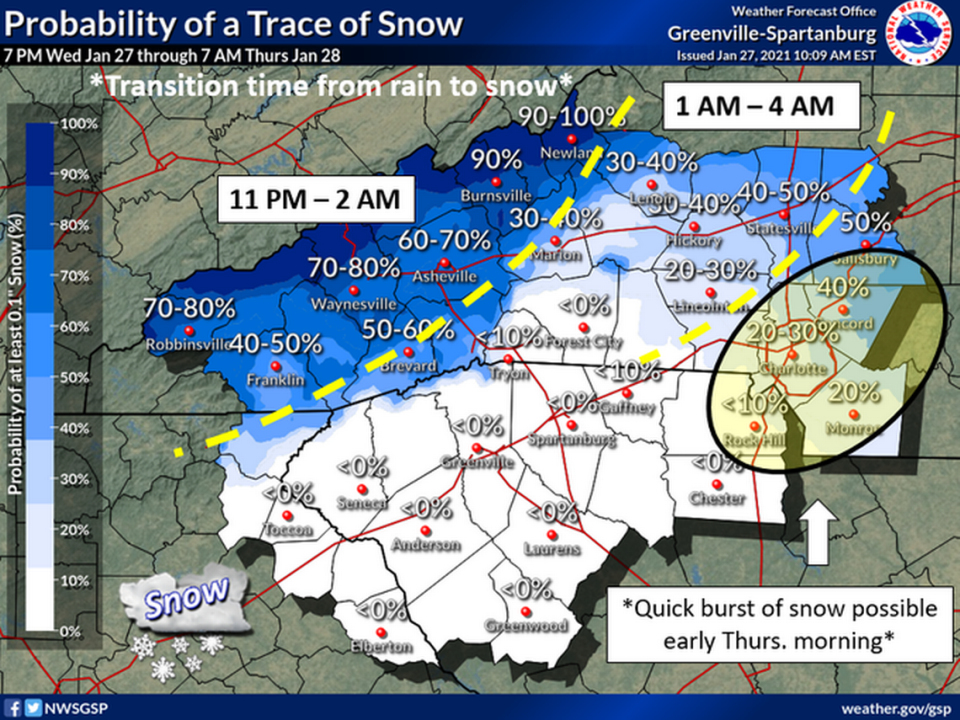
Snow chances leap to 90% in parts of the North Carolina mountains, including Burnsville and Newland. Asheville has a 60% to 70% of snow, NWS forecasters said.
Any flakes that do form are expected between 1 a.m. and 4 a.m. in Charlotte, according to the NWS office in Greer, S.C.
Other forecasts are putting a damper on the chance of snow in Charlotte.
Observer news partner WBTV is calling for only rain from 11 p.m. Wednesday to 1 a.m. Thursday, light rain at 2 a.m., showers at 3 a.m. and clouds only from 4 a.m. on.
With respective lows of 25 degrees and 27 degrees predicted for Charlotte on Thursday and Friday nights, temperatures will again be cold enough for snow, but clear skies are forecast each night, according to the NWS. Charlotte has a 70% chance of rain on Saturday night.
Snow forms when the atmospheric temperature is at or below freezing, 32 degrees, according to the National Snow and Ice Data Center.

