Snow is forecast for Sioux Falls up to 5 inches Friday. Here's what to expect and when
Sioux Falls woke up to some new snow on the ground Friday, and it's scheduled to continue falling throughout the day, according to the NWS.
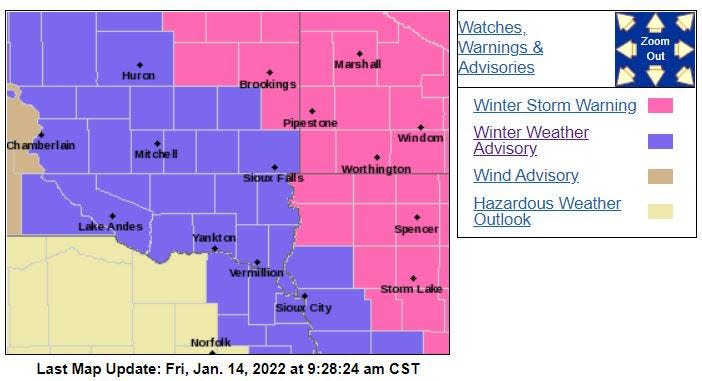
Falls remains under a Winter Weather Advisory while areas to the north and east into Minnesota are under a Winter Storm Watch.
Here's the latest info from the NWS on Friday's winter weather:
What's the snow forecast in Sioux Falls?
The big thing to watch out of the NWS in Sioux Falls will be the updated forecasts on snow totals as the day progresses. As of Friday morning, Sioux Falls had its snowfall amount predicted at 3-5 inches for Friday.
The high for Friday will be 32 in Sioux Falls and temperatures will take a big dip throughout the day for a low of 1, according to the NWS.
When is the snow going to start falling?
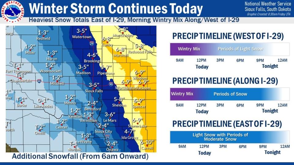
Residents in Sioux Falls and surrounding areas woke up Friday morning to light snow and a wintry mix. This should progress through Friday morning into just snow that should start after noon, according to the NWS.
Peak snow hours are forecast from noon to 9 p.m. Friday in Sioux Falls and along and east of Interstate 29.
Previously: Friday winter storm in Sioux Falls
How much snow is expected?
The predicted snow amounts have changed since Thursday with Sioux Falls now predicted to get less snow.
As of Friday morning, the NWS forecasts Sioux Falls will get between 3-5 inches of snow, but that could change throughout the day.
Areas east of Interstate 29 will see larger amounts of snow compared to areas west of the interstate, according to the NWS.
The Winter Weather Advisory for Sioux Falls and surrounding areas will last until midnight on Friday but could be extended.
Here's what other cities could see in snow Friday:
Madison: 3-5 inches
Brookings: 4-6 inches
Watertown: 3-5 inches
Vermillion: 1-3 inches
Yankton: 1-2 inches
Worthington, Minnesota: 6-9 inches
More: Get ready: A major snowstorm is forecast to roar across the Midwest, South and East Coast
As of 11 a.m. these are the snowfall totals in Sioux Falls and surrounding areas, according to the NWS:
Marshall, Minnesota - 5.5 inches
Windom, Minnesota - 4 inches
Pipestone, Minnesota - 2.5-3 inches
Okoboji, Iowa - 2.5-3 inches
Ocheyedan, Iowa - 2 inches
Sioux Falls - 0.5 inches
Here's an outlook on the next few days, according to the NWS
Friday night: Snow, mainly before 10 p.m. Patchy blowing snow before 3 a.m. Low around 1. Blustery, with a north northeast wind 15 to 20 mph, with gusts as high as 30 mph. Chance of precipitation is 90%. New snow accumulation of less than one inch possible.
Saturday: Mostly sunny, with a high near 14. North wind 5 to 10 mph becoming south in the afternoon.
Saturday Night: Increasing clouds, with a temperature rising to around 18 by 5 a.m. South wind 10 to 15 mph.
Sunday: Partly sunny, with a high near 36. South southwest wind 10 to 15 mph becoming northwest in the afternoon.
Sunday Night: Mostly cloudy, with a low around 20. Northwest wind 10 to 15 mph.
MLK Day: Mostly cloudy, with a high near 35.
Monday Night: Partly cloudy, with a low around 21.
Tuesday: Mostly sunny, with a high near 37.
Tuesday Night: Mostly cloudy, with a low around 1.
Wednesday: Mostly sunny, with a high near 12.
Wednesday Night: Partly cloudy, with a low around -5.
Thursday: Mostly sunny, with a high near 18.
Got a story idea from your community? Email reporter Alfonzo Galvan at agalvan@argusleader.com or follow him on Twitter @GalvanReports.
This article originally appeared on Sioux Falls Argus Leader: Winter storm snow forecast in Sioux Falls: What to expect Friday

