Significant winter storm disrupts school, transit across Atlantic Canada
The mighty winter storm trekking across Atlantic Canada has led to numerous travel and school interruptions Tuesday, with numerous closures and cancellations as a result of the heavy snow, intense winds and rainfall. The system is far from finished, with impacts expected to continue into Wednesday. More disruptions to transit, schools and businesses are likely to occur again Wednesday before conditions improve.
DON'T MISS: Blizzard, twisters likely as 3,000 km-long storm eyes Canada, U.S.
Environment and Climate Change Canada (ECCC) has issued winter storm, snowfall, rainfall and wind warnings across the region, along with special weather statements.
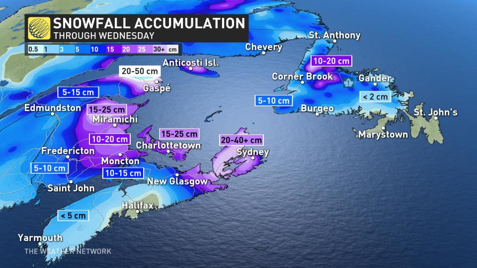
Cape Breton saw the heaviest snowfall rates develop early Tuesday morning. Over western Cape Breton, a changeover to rain has begun at many communities near sea level, however, several more hours of snow are possible over the higher terrain before warmer air reaches those elevations.
The wintry conditions resulted in school closures in various districts within P.E.I. and Nova Scotia. St. Francis Xavier University and Cape Breton University announced campus closures due to inclement weather and have rescheduled exams slated for today. Some municipal offices in Cape Breton have also been closed and transportation services have also been affected, with Transit Cape Breton and ferries to and from Sydney, N.S., being cancelled.
By Tuesday afternoon, rain moves into eastern Newfoundland and wet snow pushes across western sections. Areas in the Avalon Peninsula could see up to 50 mm of rain by late Tuesday evening with higher amounts on the Bonavista. P.E.I. will see snow move in throughout Tuesday, from east to west, before it pushes into New Brunswick in the evening.
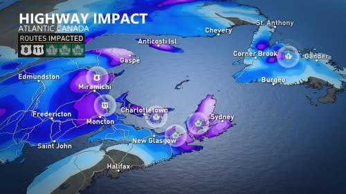
Tricky travel conditions will be a concern Tuesday overnight into Wednesday morning, especially along the Trans-Canada Highway. Road closures are possible.
Halifax, N.S., is looking more likely to dodge the heaviest snow, as the airport is off to its least snowy season on record. Nothing more than a trace has fallen. On average, 60 cm falls during the October-December period.
Cape Breton is forecast to see 20-40 cm of snow. Northern and eastern New Brunswick will get up to 20 cm as the system tracks into Wednesday morning. P.E.I. could see 15-15 cm of snow, which does not seem like a lot, but wind gusts of 70-90 km/h will accompany the snow and create whiteout conditions for several hours.
Along with the precipitation, wind gusts will also be an important element of the system to consider. Winds have ramped up for the south coast of Newfoundland, with gusts forecast to exceed 100 km/h.
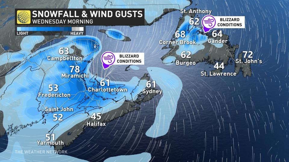
The strongest winds will be gusting over 100 km/h Tuesday overnight into early Wednesday morning. Models suggest southwestern Newfoundland and northeastern Newbrunswick to have the highest probability of wind gusts over 100 km/h.
In the long range, another messy system is set to move in for the weekend. Northern areas of the East Coast will see snow, while the south could end up with rain.
Stay tuned to The Weather Network for the latest forecast updates on Atlantic Canada.

