Spring snowstorm to bring wintry weather back to Northeast, Great Lakes

Even though spring is officially underway, a snowstorm threatens the return of wintry weather in the Northeast.
Millions of Americans might think the idea of winter weather is just a joke given the snow drought that parts of the Northeast have experienced this year. However, there's even a chance, if a storm materializes, that some cities could end up with more snow during spring than the entire winter season.
"Old Man Winter may be serious this time with accumulating snow likely, mainly over interior locations, just when millions may have thought that spring had a stranglehold on the region," AccuWeather Senior Meteorologist Brett Anderson said.
 |
The setup is likely to unfold with snow in the Midwest and the Northeast, as two storms taking aim at the region, according to AccuWeather forecasters.
The first storm will travel from the lower Mississippi Valley on Sunday to the eastern part of the Ohio Valley on Monday. However, a second storm is forecast to develop along the North Carolina coast during Monday and travel northeastward, just off the mid-Atlantic and New England coasts from late Monday to Tuesday morning.
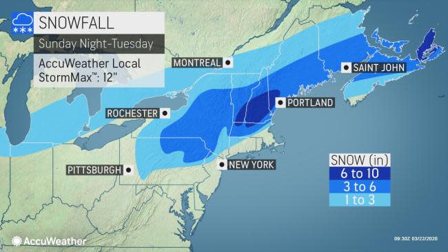
Just enough cold air is expected to linger from this weekend to allow the primary form of precipitation to occur in the form of snow across interior portions of the Northeast. Closer to the mid-Atlantic coast, and down through the Deep South, rounds of rain are expected.
"The heaviest accumulations with this upcoming spring snowstorm will likely be in the higher elevations above 2,000 feet. This includes the Catskills, Berkshires, southern Green Mountains and White Mountains, where some spots may see a foot or more," Anderson said.
 |
A general 3-6 inches of snow is forecast from northern Pennsylvania to central Maine and northern Connecticut. Lesser snow is anticipated over the valley locations in this swath, on the order of 1-3 inches.
An AccuWeather Local StormMax™ of 12 inches is forecast over the highest terrain.
CLICK HERE FOR THE FREE ACCUWEATHER APP
The majority of the snow is forecast to fall on non-paved and elevated surfaces such as grassy and forested areas as well as car tops and decks. But, for a time, the snow will likely come down hard enough to create slippery and slushy conditions on roads, especially over the higher elevations. The best chance for accumulation will likely be during the nighttime and early morning hours.
Bridges and overpasses may be especially slick anywhere the snow falls after dark and into the first few hours of daylight. Areas most likely to become slippery the fastest would be patches that do not receive direct sunlight, such as the north side of buildings and gaps in the mountains.
 |
"The worst driving conditions across interior Pennsylvania, including sections of I-80 and I-70 will be later Sunday night and through Monday morning when the sun is not a factor and temperatures are near or below freezing," Anderson said.
The I-95 corridor from Washington D.C., to Philadelphia, New York City, and Boston should have just wet roads through this, even though wet snow mixing in during the height of the storm or near its conclusion is possible over the coastal mid-Atlantic and likely in southeastern New England.
"You look at Boston," said AccuWeather Chief Broadcast Meteorologist Bernie Rayno, "I think it [the snow] will be just off to the west and north." He didn't rule out the possibility of some wet snow mixing with rain in Boston resulting in "an inch or two" of accumulation.
The heaviest snowfall across much of New York state will occur on Monday before tapering off Monday night. Across interior New England, expect the heaviest snowfall from late Monday through Monday night.
"The Massachusetts Turnpike could be a real mess the way things look now from Monday night to the start of the day Tuesday," AccuWeather Senior Meteorologist Joe Lundberg said.
 |
There is a remote chance that the coastal storm could strengthen and track in such a way as to bring a period of heavy snow to the I-95 mid-Atlantic and southern New England areas.
CLICK HERE FOR THE FREE ACCUWEATHER APP
If the coastal storm remains weak or does not hug the coast, then light, non-accumulating snow or even rain may fall throughout the Northeast.
"At least for those over the interior Northeast, it is not quite time yet to put away the shovels and snowblowers," Anderson said. "Despite that spring will have officially gotten underway, it is still March and March has offered plenty of winter storms in the past."
 |
The snowstorm was no joke for television comedian Ben Wrigley who has to shovel show away from his car on Central Park West at 61st Street in New York, March 20, 1956. The staggering snow-clearing job got underway in the city following the 24-hour blizzard. (AP Photo/Jacob Harris) |
There have been accumulating snow events in New York City well into April, for example. A storm on April 7, 2003, brought several inches of snow to the New York City area.
Accumulating snow on roads has occurred during the middle of March in the Big Apple as recently as 2018.
 |
A New York City Parks Department employee uses a snowblower to clear a path after a snowstorm on the Brooklyn Heights Promenade, Thursday, March 22, 2018. (AP Photo/Mark Lennihan) |
Winter 2019-20 officially ended on Thursday at 11:50 p.m. EDT with a total of only 4.8 inches in New York City, a mere 20% of the normal seasonal snowfall to date.
Keep checking back on AccuWeather.com and stay tuned to the AccuWeather Network on DirecTV, Frontier and Verizon Fios.
