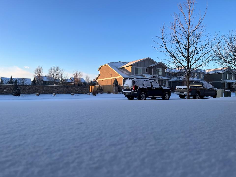
Snow and a nearly 50-degree temperature plunge greet Fort Collins on Saturday
- Oops!Something went wrong.Please try again later.
Snow is falling Sunday morning in Fort Collins as Colorado's cold snap continues through Martin Luther King Jr. Day weekend.
The good news for those unlucky enough to have to venture west from the Fort Collins area is that the Colorado Department of Transportation has lifted all road closures in Jackson County. Portions of Colorado highways 14 and 125 were temporarily closed Saturday due to poor conditions.
While the storm only dropped an inch or two of snow on the northern Front Range Friday into Saturday, some mountainous areas in Jackson and Routt counties received more than 15 inches.
Snow and bitter cold remains in the forecast for Sunday and Monday. Here's the latest update from the National Weather Service in Boulder. The Coloradoan will provide weather and closure updates throughout the weekend.
Fort Collins Sunday cold and snow outlook
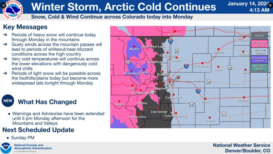
The Fort Collins area could see 1-2 inches of snowfall Sunday, mainly before 11 a.m. The NWS is forecasting a daytime high of 3 degrees before the overnight low dips to minus 2. Light northeast winds mean residents will get a temporary reprieve from dangerous wind chill, though winds are expected to pick up into Monday.
Fort Collins Martin Luther King Jr. Day cold and snow outlook
The NWS says there's an 80% chance of snow overnight Sunday into Monday with new accumulation of 1-3 inches possible by the end of the extended weekend. The forecast cold has already led to the cancellation of the annual MLK Day march in Fort Collins, with northeast winds picking up and bringing wind chill values to as low as minus 22 on Monday.
Looking into the week, Thompson School District has already called a 2-hour delay to the start of school Tuesday; Poudre School District has not yet announced any planned delay. Temperatures are expected to begin rising Tuesday, but not before Monday night brings a frigid low near minus 16 degrees.
-Eric Larsen
Saturday updates: Cold snap brings travel woes to high country
Long-anticipated snow in Fort Collins was accompanied overnight Friday by a nearly 50-degree temperature plunge as frigid air settled over Colorado for an extended weekend stay.
Overnight snowfall of between 1-2 inches was observed across the Fort Collins area, marking the northern urban corridor's first measurable snow of 2024. But the real meteorological story is the bitterly cold air that's expected to linger into Tuesday.
The National Weather Service's weather station at Northern Colorado Regional Airport in Loveland recorded a daytime high of 35 degrees at 2 p.m. Friday. Seventeen hours later, at 7 a.m. Saturday, the same station recorded a temperature of minus 14 degrees.
It's not record-breaking cold — Saturday's all-time low is minus 22 degrees — but it represents a 49-degree plunge from already near-freezing temperatures.
Temperatures are expected to stay near or below zero through Monday before the next big temperature swing comes Tuesday morning. Then, the NWS has forecast Monday's overnight low of minus 15 to climb up to a daytime high of 25.
The long-range forecast is predicting a daytime high of 42 on Wednesday.
The Coloradoan will have updates throughout the Martin Luther King Jr. Day weekend as the Fort Collins area endures this cold January blast.
-Eric Larsen
Mountain highways in Jackson county reopened; stretch of Colorado 14 closed
Earlier closures of Colorado Highways 14 and 125 in Jackson County have ended, clearing passage to U.S. Highway 40, according to emergency officials. However, a section of Colorado 14 between Walden and Kinikinik has been closed.
Mountain highway conditions can change rapidly, so sign up for text alerts by texting JALERTS to 888777 for Jackson County, or visit https://leta911.org/ to set up an account with the Larimer Emergency Telephone Authority.
-Eric Larsen
Storm dumps impressive snow totals in north-central Colorado mountains
While the winter storm sent the northern Front Range only an inch or two of snow Friday night into Saturday, National Weather Service Snotel stations in Colorado's north-central mountains recorded some impressive totals.
A station at Green Mountain south of Kremmling recorded 28.5 inches of snow, while a station near Mount Zirkel recorded 22.5 inches. A station near Rabbit Ears Pass southwest of Steamboat Springs recorded 15 inches of snow, a total that was recorded at four other stations in the region.
-Eric Larsen
Mountain roads closed at Walden due to weather conditions
State highway officials have closed Colorado Highway 14 from Walden to U.S. Highway 40, along with Colorado Highway 125 south from Walden to Granby due to poor road conditions, according to the Larimer Emergency Telephone Authority (LETA).
Colorado 125 remains open north to Wyoming, as does Colorado 14 (Poudre Canyon Highway) between Walden and Ted's Place to the east of the Poudre Canyon.
Those delayed by the closures can find a warming shelter at 410 Washington St. in Walden. Sign up for alerts about Jackson County road conditions by texting JALERTS to 888777.
-Eric Larsen
Fort Collins is on accident alert Saturday
Fort Collins Police Services on its social media sites announced the city is on accident alert until 6 p.m. Saturday, Jan. 13, due to dangerous driving conditions.
That means drivers involved in a noninjury, nonalcohol/drug related crash should exchange information and report the crash online at https://www.fcgov.com/police/coplogic-start-report.
Police also asked people to avoid traveling Saturday if possible.
-Miles Blumhardt
Protect yourself against wind chill as Colorado warning is updated
Much of Colorado is under a wind chill warning through 11 a.m. Tuesday, as expected increasing winds could bring outdoor wind chills to as low as 40 degrees below zero. According to the National Weather Service, frostbite could set in on exposed skin in as little as 10 minutes.
If you need to venture out in the days ahead, be sure to dress warmly and cover exposed skin. Having extra emergency items in your car including extra outerwear, a blanket, water and food are important if you're traveling anywhere outside of populated areas.
Thompson School District implements delayed start on Tuesday
In the realm of advanced planning, Thompson School District on Friday afternoon announced that it would delay the start of school by two hours on Tuesday. Students are out of school Monday for Martin Luther King Jr. Day.
According to a TSD news release, schools will let out at the regular time, but all schedules, starting with bus pick-up, will be delayed by two hours from their normal start times. More information on TSD weather delays can be found on the district's webpage.
Poudre School District officials on Friday afternoon said they were monitoring the weather and had not yet made a determination on the start of Tuesday's classes.
Fort Collins MLK Day march cancelled due to frigid weather
Fort Collins' well-attended Martin Luther King Jr. Day march has been cancelled due to the brutally cold weather forecast, organizers confirmed to the Coloradoan Friday. Indoor events are still planned, and Coloradoan reporter Erin Udell has the details here.
Will Fort Collins see record-breaking temperatures with this storm?
Saturday: Record maximum low is 2 degrees. Forecast is 2 degrees. Record low is minus 22. Forecast is minus 12.
Sunday: Record maximum low is 4 degrees. Forecast is 5 degrees. Record low is minus 13. Forecast is minus 8.
Monday: Record maximum low is 2 degrees. Forecast is 3 degrees. Record low is minus 11. Forecast is minus 15.
"If we get snow on the ground and clear skies that increases the chances of temperatures staying really low,'' said Russ Schumacher, state climatologist and professor in Colorado State University's Department of Atmospheric Science.
A major winter storm will bring heavy snow through Monday for the mountains, with lesser amounts for the lower elevations. Many major mountain roadways, including I-70, will experience blizzard/whiteout conditions, especially tonight/Saturday. Travel is highly discouraged. #COwx pic.twitter.com/ZZeZImM5fE
— NWS Boulder (@NWSBoulder) January 12, 2024
Colorado mountains piling up much-needed feet of snow, which is good for skiing but not travel
Colorado's northern mountains have seen more than a foot of snow this week already, and some places are expected to see 2 to 4 feet more before the storm exits. The central and northern mountains are under a winter storm warning that lasts until 5 p.m. Saturday.
Mountains: Snow will increase Friday afternoon and evening and will combine with winds gusts of 50 to 75 mph above timberline to produce widespread blowing and drifting snow, poor visibility and dangerous travel conditions. Snow may taper off Saturday, then another round of even heavier snow is expected to develop Saturday night and continue through Sunday.
Front Range/Eastern Plains: Arctic cold will settle across the areas Friday night, and dangerously cold wind chill readings are expected to last through Tuesday morning. There is potential for brief heavy snow bands Friday night for the Fort Collins, Greeley, Boulder and Denver area.
Travel impacts: Expect impacts to mountain roads, including Interstate 70, U.S. Highway 40 and Colorado Highway 14 starting in the Upper Poudre Canyon. On the plains, Interstate 76 and Interstate 70 could see travel impacts as early as Friday night.
⚠️Dangerous bitter cold arrives tonight⚠️
Action Items:
🧥🧤Dress appropriately with extra layers, coats, hats, mittens
🐶Shelter animals
🥶Avoid prolonged outdoor exposure
👷Take frequent warming breaks if you must work outdoors#COwx pic.twitter.com/zGCJfzXzK4— NWS Boulder (@NWSBoulder) January 12, 2024
Brace yourself and prepare for extended dangerous cold
The National Weather Service issued a wind chill warning from midnight Friday until 11 a.m. Tuesday from the I-25 corridor east to the state lines.
Wind chills of minus 10 to minus 30 degrees and colder are forecast even during the day for most of the warned area. In these conditions, frostbite can occur in less than 30 minutes.
Here's how to protect you, your animals and your house:
Avoid travel if possible.
Limit time outdoors and dress in warm layers, making sure to cover all skin.
Protect livestock and pets.
To prevent water pipes from bursting, drip water in the farthest faucet from your main valve, open cupboards and vanities to warm pipes, and insulate pipes in unheated areas.
If you use portable heaters, only plug directly into a wall outlet, never leave heaters on unattended and keep them 3 feet from flammable materials.
❄️Snow forecast through Saturday
The mountain snow machine is switched on! Heavy snow, especially tonight, but strong winds and difficult travel conditions. Heavier Sat night-Sun night!
Banded snows on the plains starts this eve. #COwx pic.twitter.com/MyjAEqFSsx— NWS Boulder (@NWSBoulder) January 12, 2024
Fort Collins forecast looking frigid for the holiday weekend
Saturday, Jan. 13: 50% chance of snow decreasing to 40% at night with accumulation of less than a half inch expected. Partly sunny with a high of 1 degree and wind chill as low as minus 24 and continuing into night. Half inch of snow possible.
Sunday, Jan. 14: 60% chance of snow, mainly before 11 a.m. but continuing into night. Low around minus 9 and wind chill throughout the day of around minus 18. Half inch of snow possible.
Monday, Jan. 15 (Martin Luther King Jr. Day): 70% chance of snow, mainly before 11 a.m. Partly sunny and cold with a high near 3 degrees, low around minus 13 and wind chill as low as minus 23.
Fort Collins opens shelters due to extreme cold
The city declared an emergency weather event Friday night through Monday night due to forecast cold.
Men seeking overnight shelter can be added to Fort Collins Rescue Mission's bed list by going to the Murphy Center, 242 Conifer St., at the Rescue Mission's main location, 316 Jefferson St. or by calling the Rescue Mission at 970-224-4302.
Women and families seeking shelter should go to Catholic Charities, 460 Linden Center Drive.
The Murphy Center's indoor day shelter will be available to all from 8 a.m. to 5 p.m. through Monday.
This article originally appeared on Fort Collins Coloradoan: Snow and a nearly 50-degree temperature plunge greet Fort Collins

