NC ice storm update: Roads remain slick; power restored for many in the Triangle
Thousands of people were without power in the Triangle after a day of freezing rain and sleet.
Most of the Triangle was expected to get less than an inch of snow accumulation from Sunday’s winter storm, but officials predicted significant ice and strong wind gusts would knock out power for many and cause hazardous conditions on roads and highways that would make travel “nearly impossible.”
The News & Observer is tracking the most recent changes to the storm forecast and the state’s efforts to respond. Check back for updates.
Drivers cautioned about black ice
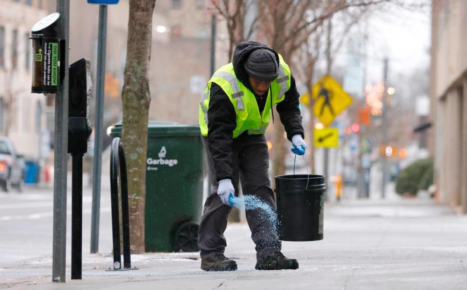
Updated 8:08 a.m. The National Weather Service cautions drivers to be aware of slick, icy roads and especially black ice on bridges and overpasses.
As the temperatures rise above freezing, after 9 a.m., conditions should improve, the Weather Service says.
But while it may warm up a little bit, there could be frequent wind gusts between 30 and 40 mph, so people should secure outdoor objects.
Here are some of our tips for driving in winter weather and if you happen to get stranded.
Some power outages remain across the state, with over 14,000 households still without power in Moore County, according to the state’s power outage map.
In Wake County, there are 1,329 households without power. Outages in the Triangle region include 512 in Harnett County; 465 in Chatham County; and 203 in Lee County.
Here are our guides for dealing with power outages.
Tractor-trailer slides off overpass in Durham
Updated 6:10 p.m.: A portion of N.C. 147 in Durham is closed near exit 16A (U.S. 15/501), according to the N.C. Department of Transportation, after a tractor-trailer appeared to slide off an overpass, falling on the highway below and blocking traffic.
A photo posted on Twitter by the Durham Police Department showed the gigantic trailer suspended in the air, resting on the side of the overpass.
Multiple lanes will be shut down for several hours, Durham police advised.
Drivers should use alternate exits at Interstate 85 North and Morreene Road.

At least 5,000 in Wake County still without power
Updated 5:50 p.m.: At least around 5,000 customers were still without power in Wake County as of Sunday evening, according to Duke Energy.
The utility service’s online outage map showed reports of power outages scattered around Raleigh and neighboring towns.
A little more than 1,100 customers were without power in Holly Springs, while close to 1,900 had lost power in Fuquay-Varina.
Power had been restored elsewhere in the county, bringing the number of people without power down from more than 12,000 earlier in the day.
About 111,000 customers across the Carolinas were without power as of Sunday afternoon, said Jeff Brooks of Duke Energy in a tweet.
Up to 3,000 outage locations were in need of repair at the time, he said.
Duke Energy asked customers experiencing outages to text OUT to 57801.
Modified hours for Chapel Hill transit on Monday
Updated 5:45 p.m.: Chapel Hill Transit is expected to resume service at noon on Monday after being suspended all day Sunday due to weather conditions.
The bus service will also operate on Sunday schedules on Monday in observance of Martin Luther King Jr. Day, the town said on its website. That means that the U route will not run, and the EZ Rider will run from noon until 7 p.m.
A full list of service hours by individual route can be found on the town’s website.
County and town officials continued to advise residents to remain indoors on Monday and “stay home if you do not have to travel for essential purposes.”

Some Wake testing sites opening late Monday
Updated 4:15 p.m.: Four COVID-19 testing sites in Wake County operated by the N.C. Department of Health and Human Services will be open Monday, but will delay opening until 11 a.m. due to the possibility of inclement weather in the morning, the health department’s testing vendor, Mako Medical, said on Twitter.
Those sites include the ones located at WakeMed Soccer Park in Cary; Word of God Church and PNC Arena in Raleigh; and Five County Stadium in Zebulon. Their hours for Monday, Jan. 17, will be 11 a.m. to 4 p.m.
The five testing locations operated by Wake County will be closed in observance of Martin Luther King Jr. Day.
Low-hanging power lines cleared on I-95
Updated 4 p.m.: Low-hanging power lines and a utility pole in need of repair that had closed Interstate 95 in both directions near Fayetteville on Sunday morning were cleared nearly six hours later, according to the N.C. Department of Transportation.
The interstate was closed near Exit 31 (N.C. 20) in Robeson County shortly after 9 a.m. as a result of the low-hanging power lines, the department said.
Just before 3:15 p.m., NCDOT said the road obstruction had been cleared.
Triangle MLK Memorial March canceled due to weather
Updated 2:20 p.m.: The annual Triangle Martin Luther King Jr. Memorial March is canceled, event organizers said.
In a post Sunday on Facebook, The Triangle Dr. Martin Luther King Jr, Committee said the event Monday had been canceled “due to potential hazardous effects of current inclement weather.”
The march had been planned to depart from the State Capitol Building in downtown Raleigh.
Organizers directed Triangle residents to www.trianglemlk.com for information on virtual events happening on Martin Luther King Jr. Day.
Durham, Cary, Morrisville suspend bus and shuttle service
Updated 12:50 p.m.: GoDurham buses will not be running until further notice, the bus service announced on Twitter.
Customers should check the bus service’s website at godurhamtransit.org or its social media accounts for further updates, and anyone with questions can call 919-485-7433.
GoCary bus services were also suspended Sunday due to “increasingly poor road conditions,” the bus service said.
A decision about Monday service will be made Sunday evening, it said, adding residents can check gocary.org/news for updates.
The smart shuttle that runs throughout Morrisville will not be in service Sunday, the town said in a news release. And the Morrisville Aquatics and Fitness Center is closed Sunday.
Gov. Cooper urges people to stay home as ice causes collisions
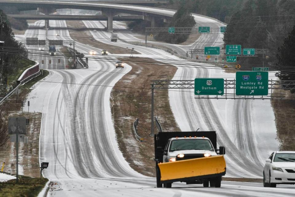
Updated 12:30 p.m.: Winter weather conditions have led to as much as a foot of snow in some parts of the state, as significant ice has formed over central North Carolina roads, Gov. Roy Cooper said at a Sunday news conference.
“There have already been a number of wrecks on our roads,” he said. “For today, the best way to avoid a car accident or getting stranded is to stay put. Fewer people on the road means fewer car crashes.”
As of Sunday morning, state troopers had responded to 460 calls for service and 200 collisions in areas affected by the storm, said Col. Freddy Johnson, commander of the N.C. State Highway Patrol.
For those who have to travel, Cooper advised reducing speed, increasing following distance and clearing off any ice or snow from your vehicle before departing.
As of 11:30 a.m., more than 41,000 businesses and homes were without power, Cooper said.
“That number, unfortunately, is likely to grow,” he added.
For those who do lose power, keep generators outside and away from windows or doors in order to avoid carbon monoxide poisoning, Cooper said.
“Never burn charcoal or use a gas grill indoors,” he added.
Officials stressed people should only call 911 for emergencies, instead reporting power outages to utility companies.
So far, 25 counties have declared a state of emergency in response to the storm, said Emergency Management Chief of Staff Donald Campbell.
“Shelters and warming centers are opening to assist residents who have lost power,” he said. “Currently there are three shelters or warming centers open in Moore, Warren and Iredell Counties, and a few others are on standby throughout the state.”
A list of open shelters can be found at readync.gov, officials said. As of 12:40 p.m. Sunday, the website listed one open shelter, Moore County Sports Complex & Recreation Center at 155 Hillcrest Park Lane in Carthage.
N.C. Department of Transportation staff and contractors are working to clear roads and cut downed trees around the state, said NCDOT Secretary Eric Boyette.
High winds in Eastern North Carolina suspended some ferry routes and scaled back others, Boyette added.

Over 100 flights canceled in, out of RDU
Updated 7:45 a.m.: More than 100 flights in and out of Raleigh-Durham International Airport had been canceled Sunday morning, as the winter weather made for difficult travel conditions.
There were 88 canceled departures and 65 canceled arrivals as of 7:45 a.m., according to RDU’s online flight status tracker.
That was about 64% of departures and 49% of arrivals at the airport.
Every Southwest Airlines flight arriving or departing from RDU on Sunday was canceled, while all departing United Airlines flights were canceled.
‘Light snow flurries’ reported in central NC
Updated 7:05 a.m.: “Light snow flurries” were reported in parts of central North Carolina early Sunday morning.
The Raleigh office of the National Weather Service said intermittent snowfall, without much accumulation of snow on the ground, had been reported in Greensboro, Asheboro and Raleigh.
535 am... IT'S HAPPENING! Light snow flurries being reported in Greensboro, Asheboro and here at the NWS office in west Raleigh. #ncwx
— NWS Raleigh (@NWSRaleigh) January 16, 2022
Earlier, flurries had also been reported in Winston-Salem, with mixed sleet and snow near Sanford and Asheboro. Freezing rain was also falling near Goldsboro, Rockingham, Laurinburg and parts of Fayetteville.
Across the region, snow accumulation will range from 1 to 2 inches along and north of Interstate 85, with ice ranging from a quarter to a half of an inch west of the U.S. 1 corridor, according to the NWS.
The NWS advised against travel.

In Raleigh and Durham, less than an inch of snow and between a tenth and a quarter of an inch of ice were expected to accumulate.
As of 5:04 a.m., a winter storm warning and hazardous weather outlook remained in effect for Wake County, as well as Granville, Vance, Warren, Franklin Counties.
The NWS said residents should expect slippery roads, strong gusty winds and scattered power outages.
Decreased snowfall estimates, worrisome ice
Updated 5:40 p.m.: In its latest briefing Saturday, the National Weather Service said it expects less snow to accumulate in the Triangle than earlier estimates. Orange and Durham Counties could see more than an inch of snowfall, but most of Wake County is expected to see less than an inch, based on new estimates.
But it cautioned: “A quick change-over to sleet and freezing rain is the main limiting factor for snow accumulation and is why these numbers are lower than previous forecasts.”
The NWS also expects stronger wind gusts, reaching speeds up to 35 mph, with the Triangle expected to have some of the strongest winds in Sunday’s storm.
Ice accumulation could be as thick as one-third of an inch, with the western Triangle counties and the Triad forecast to see the heaviest ice.
Snow, sleet and freezing rain will all start passing through the Triangle between 7 and 9 a.m. Sunday, the NWS said, with freezing rain continuing to mid-afternoon before changing over to rain as temperatures rise.
The high temperature Sunday is expected to be about 40 in the Triangle, but that won’t happen till late in the day.
The next NWS briefing will be held at 9 a.m. Sunday.
More than 60 flights canceled at RDU
Updated 3:30 p.m.: More than 60 flights arriving and departing from Raleigh-Durham International Airport had been canceled as of Saturday afternoon.
A total of 32 flights scheduled to arrive at RDU between 6 p.m. on Saturday and shortly after 9 a.m. on Sunday have been canceled, according to a flight tracker on the airport’s website.
One flight set to depart RDU on Saturday evening had been canceled, along with 30 flights scheduled to fly out of the airport Sunday morning between 6 a.m. and 9 a.m.

In an email, an RDU spokesperson said the airport cannot predict delays or cancellations as a result of tomorrow’s inclement weather, but said all passengers should call their airline before going to the airport.
Ahead of the storm, officials said they planned to keep the airport open, writing on the airport’s website that “RDU typically does not close during winter weather – even if there are significant impacts to flight operations.”
Airport employees have been mobilized to keep the airport running throughout the storm, according to the website. That includes clearing runways, taxiways, roads and sidewalks, and coordinating with the National Weather Service to receive the latest forecast.
Officials urge people to ‘please stay home’
Updated 12:00 p.m.: N.C. Transportation Secretary Eric Boyette said crews are prepared to plow and de-ice roads, and remove downed trees and debris in anticipation of snow and ice accumulation on Sunday.
More than 1,200 transportation department employees have been pre-treating roads across the state since Thursday, Boyette said.
Boyette said nearly 2.5 million gallons of brine have been spread on roads, and that the transportation department has more than 160,000 tons of salt on hand and more than 400 trucks ready to be deployed on Sunday.
“We are doing our part, but we need everyone else to do their part too,” Boyette said. “Once the storm hits later today and tonight, please stay home.”
If you must travel tomorrow, the National Weather Service advises keeping an extra flashlight, food, and water in your vehicle to stay safe in case of an emergency.
Early this morning approximately 280 crews and contractors left Florida and are currently on their way to the Carolinas ahead of the winter storm. Once the storm passes they'll join the rest of our crews and deploy to areas where they're needed most. Safe travels! pic.twitter.com/vA7T0w2hyB
— Duke Energy (@DukeEnergy) January 15, 2022
Cooper deploys NC National Guard
Updated 11:45 a.m.: Gov. Roy Cooper said on Saturday he had activated 200 members of the North Carolina National Guard who will be deployed in the western and central parts of the state, which are expected to see the most snow fall and ice accumulation, to assist with storm response on Sunday.
The National Guardsmen will be equipped with emergency response vehicles like Humvees and four-wheel-drive ambulances that can move through the snow, Cooper said, and some National Guard and state Department of Transportation teams will be staged at “trouble spots” on interstates.
Cooper announced the deployment at a news conference with other state officials at the Emergency Operations Center in Raleigh to discuss storm preparedness efforts.
Up to 750,000 customers could lose power
Updated 11:30 a.m.: As many as 750,000 customers in North and South Carolina could lose power tomorrow, and outages in some of the hardest-hit parts of the Carolinas could last several days, Duke Energy warned on Saturday.
Ahead of the storm, more than 10,000 workers including power line technicians, damage assessors and vegetation workers have been dispatched across both states, the company said in a news release. Nearly 4,100 of those workers are from companies based out-of-state, including Texas and Oklahoma.
But dangerous road conditions could delay crews from reaching hard-hit areas, Duke Energy said, delaying power restoration.
In addition to ice buildup on trees and branches, the weight of ice forming directly on power lines can cause them to fall or sag as well, Duke Energy said. Heavy, wet snow can also down power lines, the company warned.
NWS issues winter storm warning
Updated 11:30 a.m.: The National Weather Service upgraded Sunday’s winter storm watch to a winter storm warning for most of central North Carolina Saturday.
The winter storm warning covers a large part of central North Carolina that mostly lies west of U.S. 1, including Raleigh, Durham and Chapel Hill, extending to Greensboro and Winston-Salem.
The NWS said to expect one to three inches of snow and icy roads that could make travel “nearly impossible” in certain areas.
Up to a third of an inch of ice will cover roads and trees, the NWS said, and wind gusts up to 40 mph will be enough to knock over weak trees and blow tree branches onto power lines.
We have issued a Winter Storm Warning primarily along and west of US-1 and an Advisory for the Coastal Plain for this weekend's winter storm. These headlines are valid from midnight on Sunday to midnight on Monday. #NCwx pic.twitter.com/mlPD4ThP5y
— NWS Raleigh (@NWSRaleigh) January 15, 2022
The highest snow and ice totals are expected west of Wake County, in a portion of the state covering Durham, Orange, Chatham, Alamance, Guilford, Forsyth and other counties, which may see up to three inches of snow and three-tenths of an inch of ice.
According to ABC11, The News & Observer’s newsgathering partner, the threshold for tree branches to snap from ice accumulation is a quarter of an inch.
“But with the added problem of strong winds at the end of the storm, it may not even take that much ice accumulation,” the TV station reported.
The worst impacts of the storm are expected to be felt in the western part of the state, particularly the North Carolina foothills that lie north and northwest of Charlotte, which could see between six inches to a foot of snow.
The area in and around of Charlotte is expected to experience seven to eight hours of freezing rain, a National Weather Service meteorologist told The Charlotte Observer.
Wake along with Granville, Vance, Warren and Franklin counties can expect total snow accumulations of up to two inches and ice accumulations of up to a quarter of an inch, the NWS said.
In Raleigh, the NWS said, sleet and freezing rain are expected to be replaced by rain after 3 p.m.
“How long that freezing rain lasts before it turns into rain will largely determine how dangerous of a weather event this turns out to be,” ABC11 reported.
The strongest wind gusts are expected to kick in around 1 p.m., according to an ABC11 forecast of conditions.

