After snow squalls lash northern Utah, more are possible Wednesday evening along the Wasatch Front
SALT LAKE CITY (ABC4) — After powerful snow squalls blew through northern Utah and the Wasatch Front on Tuesday night, another winter storm is setting up to deliver a repeat performance on Wednesday, with squalls hitting roads in the afternoon and evening hours.
This coming storm will have impacts across Utah, and will bring widespread snow on top of complicating travel.
Wild winter #utwx with snow squall warnings through all of Northern #Utah during the evening commute ..
The last warning expired at 7:30 in Utah County — here’s a look at the conditions ⬇️⬇️ @abc4utah https://t.co/b8Pli9IrYK— Alana Brophy (@AlanaBrophyWX) January 10, 2024
Tuesday’s Squalls
The National Weather Service issued several warnings Tuesday evening for communities along the Wasatch Front as well as in Tooele, Summit and Uinta counties.
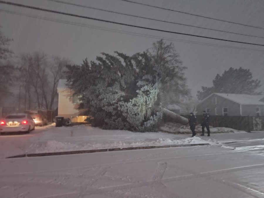
Over a period of a few hours, the squall lines brought lashing winds as strong as 60 mph, which produced blowing snow and ushered in frigid temperatures. There were even reports of thundersnow, and storm damage was reported in Brigham City after strong winds toppled a large tree.
“Tuesday’s snow squall warnings made for dangerous conditions on our roads. Emergency text alerts went out to various people, and Wednesday’s cold front looks even more organized,” said ABC4 Chief Meteorologist Alana Brophy.
Utah Highway Patrol reported 59 crashes Tuesday across the state, and hundreds of people in Salt Lake County were without power following the snow squalls. At one point Tuesday night, Rocky Mountain Power reported more than 2,000 customers were without power.
Snow squalls are quick-moving blasts of frigid air that can instantly whip up whiteout conditions and freeze moisture on roadways in minutes, creating dangerous black ice. During a squall warning, motorists are urged to stay off the roads unless travel is absolutely necessary.
As the snow squalls passed through Salt Lake County, tractions laws were put into effect for the Cottonwoods, meaning that drivers must have chains or snow tires to access the canyon roads.
Complete white out conditions in Logan #Utah as strong cold front sweeps into the state prompting a snow squall warning…
THIS IS DANGEROUS SNOW.#utwx @abc4utah
Tracking it #live at 6 pic.twitter.com/vGHps2THyC— Alana Brophy (@AlanaBrophyWX) January 10, 2024
While scattered snow showers persisted through the evening, especially in the mountains, active skies dwindled later into the night. A cold and icy Wednesday morning commute is expected.
At least one school district, Provo City, announced it was delaying the start of classes on Wednesday due to concerns of weather and road conditions.
More Snow Squalls
The early morning hours will bring a break from the snow, but the Wednesday morning commute will be cold and potentially icy, as overnight lows will dip into the low 20s for the northern valleys.
But there’ll only be brief break before another winter storm takes aim at Utah.
By late morning, pre-frontal snow showers could move along the Wasatch Front. After that, a strong cold front will yet again sweep through the state. This will feel like a one-two punch, with Wednesday’s storm system bringing the potential of additional snow squalls and widespread snow.
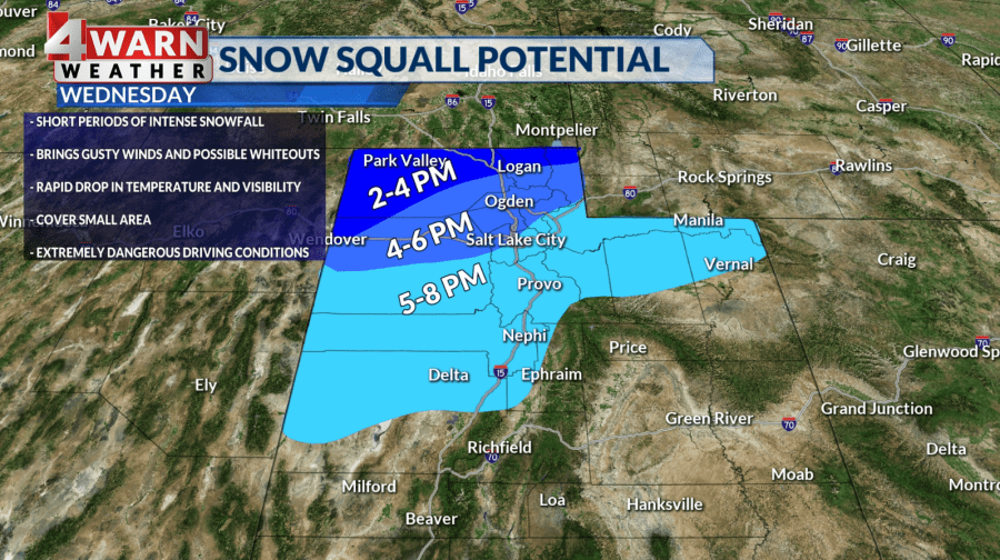
“The squall will be a little earlier Wednesday in comparison to Tuesday, but the travel impacts will be similar with whiteout conditions, extremely gusty winds and accumulating snow expected,” Brophy said.
Statewide Impact
Healthy snow accumulations are expected with Wednesday’s storm. By Thursday morning, some mountain areas, such as the Cottonwoods, could see 48-hour accumulations as high as 3 feet of snow.
With winter weather advisories in effect, major cities along the Wasatch Front will see periods of accumulating snow. Brophy forecasts the Ogden Valley will get hit hard, with Salt Lake, Tooele, Utah, Davis and Utah counties looking at accumulating snow.
Wasatch Front valleys can expect 4-10 inches of snow through Thursday, with higher totals between 8-16 inches expected for the benches. Northern Utah mountain valleys, including the Wasatch Back, could see between 10 and 20 inches stack up.
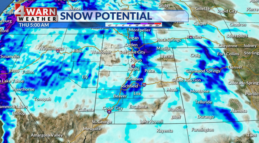
The storm will dip into central Utah, where valleys could see between 3 to 6 inches of snow and the mountains could pick up between 8 to 16 inches through Thursday.
Snow amounts lessen to the south and east, but Castle Country and the Uinta Basin could see a few inches, while the valleys in southern Utah could pick up anywhere from a trace to 3 inches over the next two days.
“The southern mountains could get between 4 to 8 inches of fresh snow, which is needed to help boost snowpack,” Brophy said. “Cold enough air is present that there’s even a chance St. George, in the southwest corner of our state, could see snow overnight Wednesday into Thursday morning.”
More Storms This Weekend
Active weather stays in the forecast for this weekend.
Another storm will impact northern Utah on Friday, and heading into the weekend, there’s potential of a larger storm with a connection to an atmospheric river to move into Utah.
An atmospheric river is like a river in the sky that transports water vapor outside of the tropics.
“The weekend storm could pack a punch, precipitation type is up in the air, but that’s a storm we will monitor closely and keep you forewarned about,” Brophy said.
For the latest news, weather, sports, and streaming video, head to ABC4 Utah.

