Snow squall warnings expire, but heavy snow expected across Utah

SALT LAKE CITY (ABC4) — For the second day in a row, a powerful winter storm descended on the Wasatch Front during the evening commute, bringing heavy snow and strong winds.
Although the winds in Wednesday’s winter storm weren’t as powerful as those the day before, this system is packing more snow, which will likely affect the Thursday morning commute.
Squall Warnings Expire
Another organized cold front blew into northern Utah on Wednesday afternoon, prompting three snow squall warnings for the northern part of the Wasatch Front.
However, by 4 p.m., the intensity of the squalls weakened as they entered the Salt Lake City area, and snow became the main weather story.
Heavy snow and freezing temperatures stalled evening traffic on highways along the Wasatch Front.
As of 7:30 p.m. Utah Highway Patrol reported 105 crashes across the state. It’s unclear if any of those involved deaths or serious injuries.
Snow squall passing through the Ogden area. ❄️ Stay safe and off the roads if you can!
🎥 :Jamie Richards#utwx pic.twitter.com/aK44mLce8E— Nate Larsen (@NateLarsenWX) January 10, 2024
The difference between the snow squalls Tuesday and Wednesday were the winds. On Tuesday, strong winds walloped the Wasatch Front with gusts up to 70 mph, causing storm damage and cutting power to thousands.
Wednesday’s cold front had 35 mph wind gusts but more snow associated with the passing cold front. With cold temperatures in place, snow easily accumulated on roads and sidewalks.
Messy Commute
UDOT is warning of major travel impacts along the Wasatch Front and the entire I-15 corridor through Thursday morning.
As the cold front heads toward southern Utah, the potential for lake effect snow set ups for areas along the Great Salt Lake.
“This is a statewide storm. It’s going to sweep into central Utah and push down south,” said ABC4 chief meteorologist Alana Brophy.
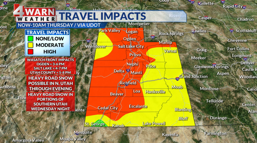
Lake effect snow could keep showers churning from about 10 p.m. through the early morning hours in northern Utah. Areas southeast and south of the Great Salt Lake could see additional snow accumulation.
Overnight snow showers could set the stage for an icy, cold and slick morning commute Thursday.
“Give yourself some extra time in the morning, with counties including parts of Salt Lake, Davis, Utah, and Tooele,” Brophy said.
How Much More Snow?
A winter storm warning remains in effect for the Wasatch Mountains, the Wasatch Back, the Western Uintas, and the Wasatch Plateau.
According to Brophy, the northern mountains could see an additional 10 to 20 inches of snow by Thursday evening, with the Cottonwoods possibly seeing up to 2 more feet of powder.
These totals come on top of Tuesday’s snow. Taken together, areas such as the Cottonwoods could count 3 feet of fresh snow over the last 48 hours. And more is on the way.

Single-day totals for the mountain valleys could be up to a foot by Thursday evening, with isolated areas seeing up to 18 inches.
As for the northern valleys, which are under a winter weather advisory, 1 to 4 inches of snow is expected, with areas hit by lake effect snow possibly seeing additional 4 inches. The benches could get between 5 to 10 inches of snow.

The mountains of central Utah could see up to a foot of new snow while the southern mountains could get around 5 to 10 inches. Valleys in central and southern Utah could see trace amounts to 4 inches stack up.
St. George could see straight snow fall early Thursday, although it won’t likely be more than a dusting.
Avalanche Danger
Mountains across northern, central and southern Utah are currently under “high” risk of avalanches as back-to-back storms dumped heavy snow on the high country.
These repeated snowfalls over the last week come following an unusually dry December. This means that dense, heavy snow is sitting on top of fragile, sugar-like snow, making the entire mountain snowpack unstable.
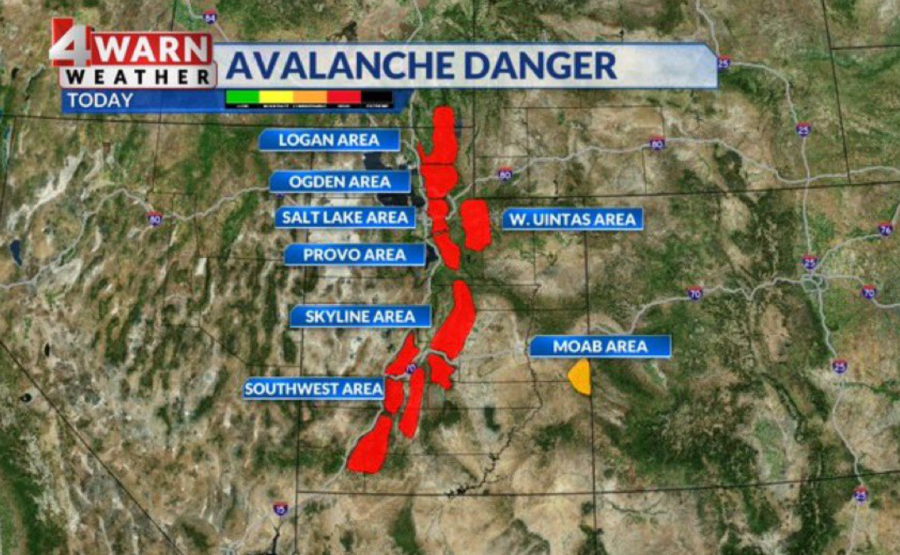
Craig Gordon, avalanche forecaster with the Utah Avalanche Center, advised skiers and snowboarders to stay on low-angle terrain in the backcountry.
“Pump the brakes,” he said, adding: “We can still enjoy this amazing snow.”
Traction rules are currently in effect in the Cottonwoods, meaning that drivers must have chains or snow tires if they want to enter the canyon roads.
More Winter Storms This Weekend
Active weather stays in the forecast as the weekend approaches.
Another storm will blow into northern Utah on Friday, and heading into the weekend, there’s potential of a larger storm with a connection to an atmospheric river.
An atmospheric river is like a river in the sky that transports water vapor outside of the tropics.
“The weekend storm could pack a punch, precipitation type is up in the air, but that’s a storm we will monitor closely and keep you forewarned about,” Brophy said.
For the latest news, weather, sports, and streaming video, head to ABC4 Utah.

