Here's what to know about the winter storm forecast and potential snowfall totals this week in Milwaukee and Wisconsin
A winter storm warning for Milwaukee County and its surrounding areas took effect 9 a.m. Thursday and is set to stretch to 6 a.m. Saturday. Area residents and officials are bracing for potential blizzard-like conditions heading into the weekend.
It's not ideal for holiday travelers. Here's what to know.
How to keep safe if you have to drive, travel in Wisconsin during a winter storm
Wind gusts forecast to top 55 mph Thursday and Friday in southeast Wisconsin, could result in power outages
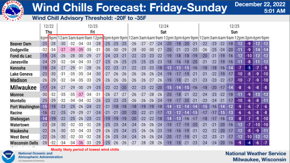
The Milwaukee/Sullivan branch of the NWS said it anticipated very strong winds Thursday night through Friday night (gusts up to 45-55 miles per hour), with winds strong enough to damage tree limbs and cause sporadic power outages. Blowing and drifting snow was expected to impact travel through Saturday, and bitter cold was expected to move in Thursday through Sunday morning, with wind chill values between 15 and 25 below zero, and maybe even lower.
We'll see the snow intensity continue or pick up a little bit as a front comes through (on Thursday)," said Andy Boxell, senior meteorologist with the National Weather Service. "Once that front comes through, winds will start to get pretty blustery from the northwest, and we'll start to see some blowing and drifting snow."
Boxell expects that to last through the night and into Friday morning, when the wind gets really dangerous.
"(Friday is) when we have the potential to see 40 to 50 mile-per-hour wind gusts," he said. "Thursday is more 20- to 25-miles-per hour, which will be enough to cause some issues, but maybe not the intensity we'll see Friday."
Places like Sheboygan, Racine, West Bend and Kenosha are expected to experience the most severe wind gusts with winds expected hover around 50 mph on Friday morning and into the afternoon.
How much snow is expected in Milwaukee and other parts of Wisconsin?
About 2-4 inches of snow is expected in the Milwaukee area and elsewhere south and east of Madison, while 3-6 inches of snow is expected near Fond du Lac and Sheboygan. Near Green Bay and Manitowoc, 3 to 6 inches is expected. Door County could see 7 inches.
The bulk of the snow is expected to fall by Friday morning.
Strong winds will create blowing and drifting snow, making travel dangerous.
Snow totals from around Wisconsin as of Thursday
Here is a sampling of snow totals around the state as of Thursday afternoon, according to the National Weather Service:
Combined Locks - 4 inches
Tomah - 3 inches
Sturgeon Bay - 4.4 inches
Eau Claire - 5 inches
Rhinelander - 6 inches
How to keep safe if you have to drive, travel in Wisconsin during a winter storm
How cold is it forecasted to be Thursday and Friday?
The weather service estimated temperatures would drop to single digits in most areas by Thursday afternoon.
Wind chills will fall to as low as 35 degrees below zero, with the coldest of these temperatures expected to happen between Thursday night and midday Friday.
Weather terms explained:What counts as a blizzard, the difference between a storm watch and warning, and what wind chill means
Is this going to be a 'blizzard'?
It's definitely in play. The National Weather Service predicts that late Thursday and all day Friday are the most likely timeframes for blizzard conditions.
It is important to note that a blizzard designation has nothing to do with volume of snowfall.
For a storm to gain official "blizzard" designation, it must feature sustained winds or frequent gusts over 35 miles per hour and visibility under a quarter mile for three straight hours.
And the weather service has warned that the potential for blizzard conditions Thursday-Saturday could quickly lead to potentially life threatening situations for individuals traveling by car.
Meteorologist Sam Kuffel of CBS 58 noted that it's been four years since any part of southern Wisconsin was officially under a blizzard warning, with the last date impacting Kenosha, Racine and Walworth counties on Nov. 25, 2018.
It's been over 4 years since parts of southern WI were under a Blizzard Warning. Kenosha, Racine, and Walworth counties were under one on Nov. 25, 2018.
Milwaukee county hasn't been under one since the Groundhogs Day blizzard of 2011. #wiwx pic.twitter.com/HxvDjAWjss— Sam Kuffel (@SamKuffelWx) December 19, 2022
Milwaukee County hasn't been under an official blizzard warning since Feb. 2, 2011 — four days before the Green Bay Packers last won the Super Bowl.
Sophie Carson of the Journal Sentinel staff contributed to this report.
Milwaukee weather radar
Refresh your browser if the radar isn’t working or click here if you can’t see it.
Our subscribers make this reporting possible. Please consider supporting local journalism by subscribing to the Journal Sentinel at jsonline.com/deal.
DOWNLOAD THE APP: Get the latest news, sports and more
This article originally appeared on Milwaukee Journal Sentinel: Wisconsin snowstorm weather forecast, blizzard possible in Milwaukee

