Snow whitens Seattle as cold air takes hold of western US into Tuesday
A sweep of cold air is bringing snow to the mountains and even the lower elevations of the western United States into Tuesday.
Behind Saturday's storm which unleashed flooding and mudslides across California, a colder system is rolling ashore, bringing the lowest temperatures of the winter so far to the Northwest.
The storm is bringing enough cold air for snow to fall at sea level across the Pacific Northwest.
Astoria, Oregon, which lies right along the coast, reported snow throughout Sunday night.
I-5 is now snow-covered in areas from Bellingham to just north of downtown Seattle. Slow down and be alert! #wawx #wasnow pic.twitter.com/aXFMkVRYRH
— NWS Seattle (@NWSSeattle) February 4, 2019
Snow was accumulating and creating slippery travel along the Interstate-5 corridor early Monday morning.
The first snowflakes since March 24, 2018, fell in Seattle late Sunday.
This is the first measurable snow in the city since it received 1 inch on Feb. 21, 2018, according to AccuWeather Meteorologist Brett Rathbun.
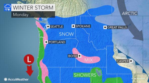
Snow showers will linger across the Seattle metro area through Monday.
Portland, Oregon, can also be whitened with a bit of snow to start the new week.
Rathbun warned that slippery travel would be possible across the area.
Motorists and pedestrians should use extra care when heading to and from work and school on Monday.
Travel is likely to be extremely difficult over I-5's Siskiyou Summit in Oregon, where 6 inches of snow or more can pile up through Monday.
As temperatures plummet across the Pacific Northwest into Tuesday, any wet or slushy areas on untreated roads and sidewalks can turn icy.
Download the free AccuWeather app to see how much snow is expected in your area and just how cold it will get.
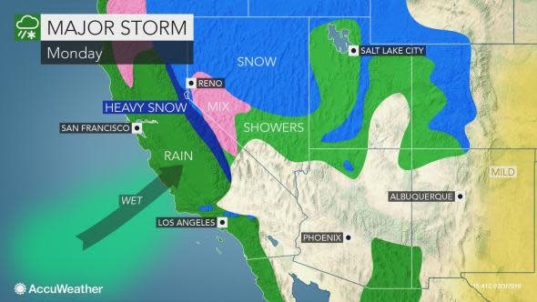
"During Monday and Tuesday, the storm is forecast to drop southward along the California coast and bring rain showers at low elevations and snow showers to the mountains, including the passes in Southern California," AccuWeather Senior Meteorologist Alex Sosnowski said.
Travelers over the Grapevine should use caution and be prepared for slippery travel.
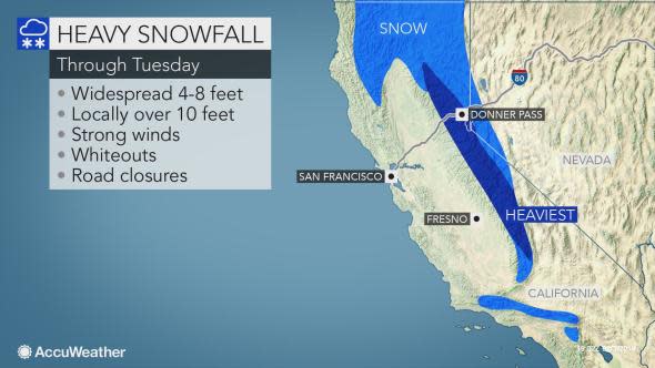
Feet of snow will continue to inundate the Sierra Nevada into Tuesday, meaning more treacherous travel, chain requirements and possible closures.
Snow is also likely to whiten the northern part of the Great Basin as colder air moves in from Monday to Tuesday.
While this storm will not bring nearly as much rain and wind to California as Saturday's system, any additional rainfall in the hardest-hit areas can hamper cleanup efforts, disrupt travel and create new flooding and mudslide hazards.
A few thunderstorms with small hail can even rumble across Northern and central California through Monday. An isolated waterspout or two cannot be ruled out.
Dry but chilly weather will prevail across the West Coast as the storm moves into the Four Corners states at midweek.

