What's next: Watch for difficult roads and possibly higher wind. A good day to stay home.
UPDATE, Monday:
We've seen the snow. It sounds like some wind might be ahead of us.
What about more snow this week? Here's where the National Weather Service forecast stands right now —
"Today, a slight chance of snow showers before 1pm. Mostly cloudy, with a high near 33. Breezy, with a west wind around 20 mph, with gusts as high as 40 mph. Chance of precipitation is 20%.
Tonight: Mostly cloudy, then gradually becoming mostly clear, with a low around 17. Breezy, with a west wind 16 to 21 mph decreasing to 10 to 15 mph after midnight. Winds could gust as high as 39 mph.
Tuesday: Sunny, with a high near 39. Southwest wind 8 to 10 mph, with gusts as high as 20 mph. Tuesday Night: Increasing clouds, with a low around 25. Southwest wind around 7 mph.
Wednesday: A slight chance of showers after 1pm. Partly sunny, with a high near 47. Southwest wind 9 to 11 mph, with gusts as high as 23 mph. Chance of precipitation is 20%. Wednesday Night: Rain showers likely before 4am, then rain likely, possibly mixed with snow showers. Mostly cloudy, with a low around 28. Chance of precipitation is 70%."
UPDATE, Sunday night:
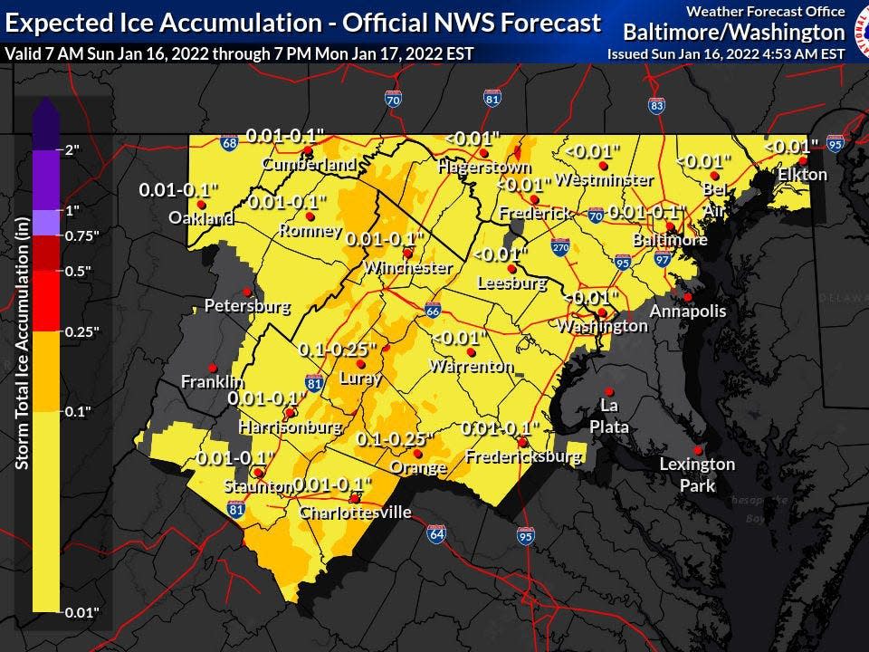
With heavy snow on the ground, the next thing to worry about might be continuing sleet and icing overnight Sunday and high winds Monday.
The National Weather Service: "
WIND ADVISORY IN EFFECT FROM 8 AM TO 8 PM EST MONDAY...
* WHAT...West winds 20 to 25 mph with gusts up to 55 mph expected.
* WHERE...Portions of The District of Columbia, central, north central, northeast, northern and southern Maryland, northern, northwest and western Virginia and eastern and panhandle West Virginia.
* WHEN...From 8 AM to 8 PM EST Monday.
* IMPACTS...Damaging winds will likely blow down scattered trees and power lines. Scattered power outages are possible. Loose outdoor objects may be blown away or damaged.
UPDATE, mid-day:
VDOT: "Snow is already coating many roadways in the Shenandoah Valley and Alleghany Highlands including Interstates 81 and 64. Sunday’s winter storm is spreading across the region from south to north, and is expected to bring heavy snow as well as sleet and ice. The Virginia Department of Transportation urges motorists to avoid all but emergency travel.
The region, including Interstate 81, has terrain with steep grades that increase travel hazards during snow and ice events. This is especially true for truck traffic and it is important that trucks avoid the region, particularly I-81, on Sunday and into early Monday.
VDOT employees and contractors are mobilized throughout the 11-county Staunton District, and are plowing and treating roads as needed. Wreckers are staged at several locations, and tree-removal crews have been notified for deployment as needed.
As of 11:30 a.m. Sunday, minor to moderate road conditions are reported in the counties of Alleghany, Bath, Rockbridge and Highland. Slick conditions are expected throughout the Staunton District by early afternoon."
Earlier:Snow already started to fall about 10 a.m. Sunday in Rockbridge County, and we're in for more of it. Lots more.
As the Staunton VDOT account Tweeted: "The storm is steadily moving north... with its cold, dead eyes focused on the rest of our district. Stay home if you can."
SUNDAY weather forecast: snow
MONDAY wind outlook
Partly sunny, with a high near 34. West wind around 18 mph, with gusts as high as 39 mph.
Winter weather is coming again- the time to prepare is NOW ❄️
-Get your emergency supplies today
-Only travel if urgent once the #wx begins. Get the @RedCross Emergency app for more tips/ follow @VDEM @VaDOT @VSPPIO & local emergency officials for updates #WinterStormIzzy pic.twitter.com/YYFr3pfpxq— Red Cross Virginia (@VARedCross) January 15, 2022
...Also, if you believe some meteorologists on Twitter, next weekend will bring another, perhaps larger, snowstorm.
This article originally appeared on Staunton News Leader: Staunton snow forecast, with travel advisory from VDOT about icy roads
