Snowstorm eyes northeastern US just before Valentine's Day


While unseasonably warm conditions in the Northeast as of late may make it seem unlikely that snow is in the future, AccuWeather meteorologists say an approaching storm will blanket part of the region with snow before the middle of the upcoming week.
For weeks, AccuWeather's team of long-range forecasters has been predicting a flip in the weather pattern around the middle of February. That forecast is about to be realized as the impending storm is accompanied by colder conditions for much of the Northeast early next week.
 |
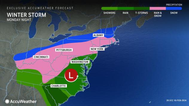
The first part of the storm will struggle to find cold air in much of the Ohio Valley, the central Appalachians, the mid-Atlantic and southern New England, AccuWeather Chief On-Air Meteorologist Bernie Rayno said.
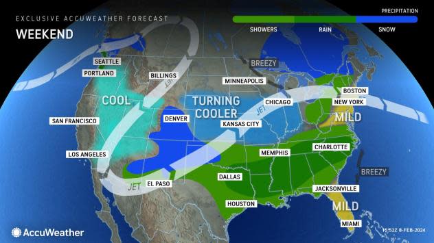
This weekend, high temperatures will range from the 40s over the northern tier of New England to the 60s around the Chesapeake Bay. Temperatures will trend much lower ahead of the storm from Sunday to Monday but will still be too high in many locations to allow snow as precipitation begins.
 |
In much of the Ohio Valley, mid-Atlantic, central Appalachians and southern New England, precipitation during the first part of the storm will be in the form of rain or a mixture of rain, wet snow and perhaps a little sleet from later Monday to Monday night.
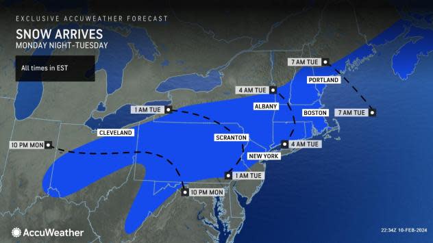
However, during the second part of the storm, beginning in some areas as early as Monday night, portions of the central Appalachians, the upper mid-Atlantic and New England are likely to transition to all snow, which may come down at a heavy rate for some.
 |
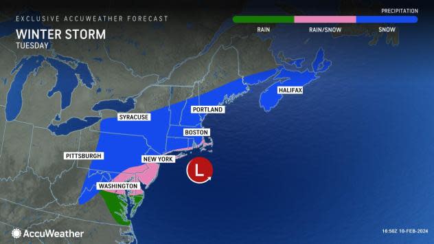
"The way the cold air will invade the storm it appears the best bet for a heavy snowfall will be from northern Pennsylvania to southeastern upstate New York, and southern and central New England, especially from northeastern Pennsylvania on to the east from Monday night to Tuesday evening," Rayno said during his broadcast on the AccuWeather Network Friday.
Lingering warm air will cause mostly rainfall from southern New Jersey through Virginia.
"It will snow in New York City, but probably not until near the very end of the storm on Tuesday," Rayno said. Currently, about an inch of snow is in store for Manhattan, mainly on non-paved surfaces. However, snowfall is likely to ramp up quickly just to the north of Manhattan. Should it manage to snow heavily for several hours on Tuesday, then several inches of snow may pile up in all of the five boroughs that make up the metro area, as well as on central Long Island, New York.
Similarly, around Philadelphia on Tuesday, snow may struggle to accumulate much in the heart of the city, with a better chance of up to a few inches over the northern and western suburbs. Washington, D.C., and Richmond, Virginia, are unlikely to receive any meaningful accumulation from the storm. Meanwhile, Boston and Hartford, Connecticut, can expect enough snow to shovel and plow with slushy and slippery travel.
 |
Rain, fog and low clouds will slow travel from late Monday to Tuesday morning along the Interstate-95 corridor in the mid-Atlantic. Airline delays and flight cancellations will mount as snow affects Boston and later spreads to New York City and Philadelphia, prompting deicing operations. Motorists heading west from New York City along Interstate 80, as well as motorists heading north on the Thruway, will encounter heavy snow and difficult travel.
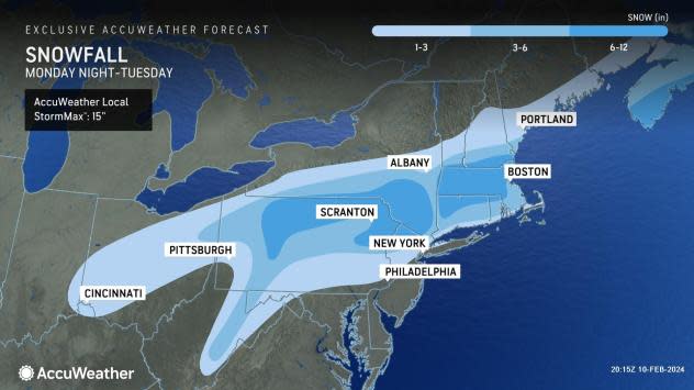
"For much of the central Appalachians to central and southern New England, accumulations will be highly dependent on elevation, where hilly areas and the mountains will pick up much more snow than the valleys or immediate coastal places," AccuWeather Senior Meteorologist Adam Douty said.
 |
The Poconos in northeastern Pennsylvania and the Endless Mountains along Pennsylvania's northern tier are likely to pick up 6-10 inches of snow, while the lower elevation cities along the Susquehanna River, like Harrisburg and Wilkes-Barre, Pennsylvania, may struggle to pick up 3 inches of slush. Other spots with the best chance for 6-10 inches of snow and locally higher amounts include the Catskills of eastern New York and much of Massachusetts, including the hills west of Boston.
There is likely to be a fairly sharp northern edge of the snow with the storm, so portions of western central and northern New York state and northern New England may receive little or no accumulation.
The snowfall accumulation from the storm depends on whether the second part of the storm can tap enough cold air. A weaker storm that fails to gather cold air and tracks farther to the south may fail to produce much snow. If the storm intensifies rapidly near the Northeast coast, rain may transition to heavy, accumulating snow in the zone from New York City to Philadelphia and perhaps Washington, D.C.
 |
As the storm begins to pull away from New England Tuesday night, northwesterly winds and a southward dip in the jet stream will bring in colder air that will linger through the week.
People on the receiving end of heavy snow may spend part of Valentine's Day shoveling or snow-blowing. Motorists and pedestrians should exercise caution in the wake of the storm. Areas of slush and standing water will freeze at night during the middle and latter part of the week.
While the storm will bring travel problems, the fresh snowfall and colder air that follows will give skiers something to cheer about following a practically snowless and mostly mild start to February.
 |
Despite the upcoming colder conditions, no blasts of severe cold are anticipated for the week. Opportunities for additional rounds of snow, including in areas missed by the Monday to Tuesday storm, may arise during the middle and latter part of February.
Want next-level safety, ad-free? Unlock advanced, hyperlocal severe weather alerts when you subscribe to Premium+ on the AccuWeather app. AccuWeather Alerts™ are prompted by our expert meteorologists who monitor and analyze dangerous weather risks 24/7 to keep you and your family safer.
