Socastee sees minor damage after Idalia. Here are the flood forecasts for Horry County
Charles Davis had to pick up his flag pole after it was knocked down when Tropical Storm Idalia rolled through the Socastee area Wednesday.
Socastee has suffered from extreme flooding in the past, and Davis, a retired veteran who has lived in the Socastee region since 1984, has seen the effect of tropical storms and hurricanes on the neighborhood.
“I’ve seen a lot of people move in and out,” Davis said.
But despite having to put his flag pole up again, he sustained no damage to his house. Davis’ power did go out around 10:30 p.m. Wednesday, Aug. 30, but it was restored at around 2:30 a.m. Thursday, Aug. 31.
Socastee neighborhoods near the Intracoastal Waterway, like Rosewood, generally avoided significant damage from Tropical Storm Idalia. The Intracoastal Waterway has stayed below flood levels following the storm, according to the National Weather Service.
There is no future forecast on the National Weather Service website if the Intracoastal Waterway near Socastee will go above flood levels. NWS Meteorologist Rachel Zouzias said tidal effects will impact the water level.
Flood warnings issued across Horry County
River flooding in certain areas is expected as the weekend arrives. The National Weather Service issued a flood warning for several rivers in the Pee Dee region.
The National Weather Service rates flood threat in order of severity from:
Action
Minor
Moderate
Major.
The Little Pee Dee River has a flood warning starting Thursday evening and is expected to experience major flooding possibly Sunday, Sept. 2, according to the NWS.
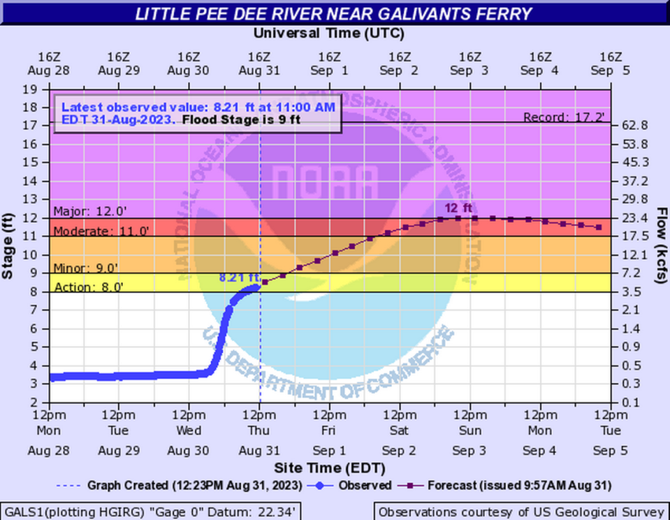
The NWS forecasts that the Little Pee Dee water level will reach 12 feet around noon Sunday, Sept. 3, and the Fork Retch community near Nichols, is expected to be impacted.
The National Weather Service forecasts that other rivers in South Carolina have a flood risk too.
The Waccamaw River near Conway is forecast to have an action flood threat, close to noon Friday, Sept. 1. The NWS forecasts the river water level will fall back to normal levels between Saturday, Sept. 2, and Sunday, Sept. 3.
The Pee Dee River at Pee Dee is forecast to have an action flood threat starting Friday, Sept. 1, around 1 p.m. and eventually rise to a minor flood threat Saturday, Sept. 2. The NWS projects the flood threat to end sometime Monday, Sept. 4.
The Black River at Kingstree, is forecast to have an action flood threat starting before 1 p.m. Friday, Sept. 1, and eventually rise to a minor flood threat sometime Saturday, Sept. 2. The NWS forecasts the flood threat to fall to action about Tuesday, Sept. 5.
At Black Creek, near Quinby, water levels are currently at a minor risk of flooding and are forecast to reach a moderate flood threat of 15.1 feet sometime Friday, Sept. 1. The Black Creek flood threat will fall to action Sunday, Sept. 3, according to the NWS.

