South Florida under tropical storm warning from potential Alex, winds up to 40 mph
Tropical storm warnings wrapped Florida from Sarasota to Titusville this morning as a gush of moisture in the western Caribbean tries to become the first named cyclone of 2022.
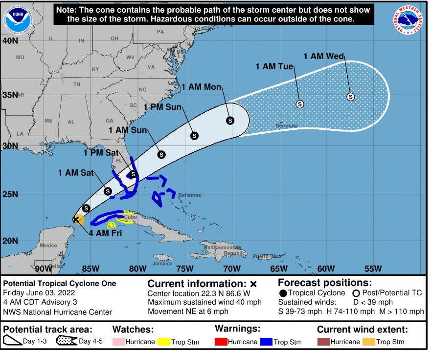
The National Hurricane Center expects the budding system to muscle up to Tropical Storm Alex before making a landfall along the southwest coast Saturday morning. Watches were changed to warnings, including for Palm Beach County, at 5 a.m.
Dubbed Potential Tropical Cyclone One — a technical title given to disturbances that haven't gained a closed circulation yet but are expected to before reaching land — the system's bluster should begin with heavy rainfall today.
While a Hurricane Hunter aircraft found sustained winds of 40 mph this morning, there was still no defined center. The NHC expects it to gain that center, making it a tropical cyclone, later today. At 5 a.m., the system was 420 miles southwest of Fort Myers moving northeast at 40 mph.
Meteorologists said the showers could rival past tropical tempests, with meteorologists comparing what’s coming to the 2020 Memorial Day deluge and Tropical Storm Eta’s drenching five months later.
National Hurricane Center: Forecasts begin May 15, and they're better than ever
Hurricane season concerns: Influx of newcomers, COVID variants and supply chain issues
Hurricane Classifications: What do the categories mean?
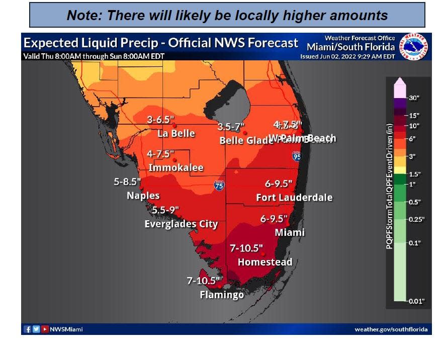
An estimated 4 to 7.5 inches of rain could fall in Palm Beach County, with higher amounts of up to 10.5 inches in Miami-Dade and Monroe counties through Sunday morning.
But National Weather Service meteorologists cautioned that “MUCH” higher amounts are possible in pockets south of Lake Okeechobee from Naples to No Name Key as the teasing area of low pressure crosses the state.
“We have a system that is pretty typical for early in the hurricane season and it’s headed right toward us,” said Chip Kasper, meteorologist in charge of the NWS office in Key West. “This is a complex weather system with a lot going on.”
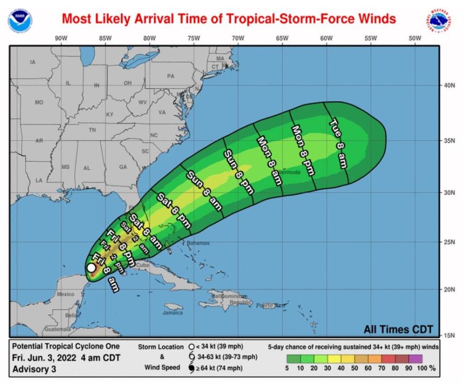
NHC meteorologists acknowledged the complexity of the forecast, saying the structure and intensity predictions are "very uncertain." As of the 5 p.m. advisory Thursday, the system was expected to become a depression overnight and reach tropical storm status by tonight. A tropical storm has wind speeds of 39 mph or higher.
It is forecast to barely hang onto tropical-storm-force winds as it crosses the state on a path that could take it anywhere from Orlando to Delray Beach with the center of NHC's forecast cone cutting diagonally from Cape Coral north of Lake Okeechobee to Sebastian.
South Florida Water Management District meteorologists said today or Saturday could produce a single-day rainfall amount that will be in the top 30 heaviest rain days seen in the past 30 years and similar to the days of wet weather in late May 2020 that preceded the formation of Tropical Storm Bertha.
Florida Power & Light: Deadly Texas storm motivates power company to prepare for extreme winter weather
What is a 'brown ocean'?: How did it turn Ida into such a monster hurricane?
Scary trend: Major hurricanes in October and November — why is it happening?
In 24 hours, areas of Palm Beach County got upwards of 6 inches of rain with higher amounts in the Treasure Coast before Bertha formed May 27 near the Georgia and South Carolina coasts.
“We think this system is going to have a big impact with rainfall that might be quite a shock for some people to see in a short period of time,” said Todd Kimberlain, lead meteorologist for the water management district.
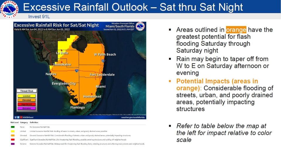
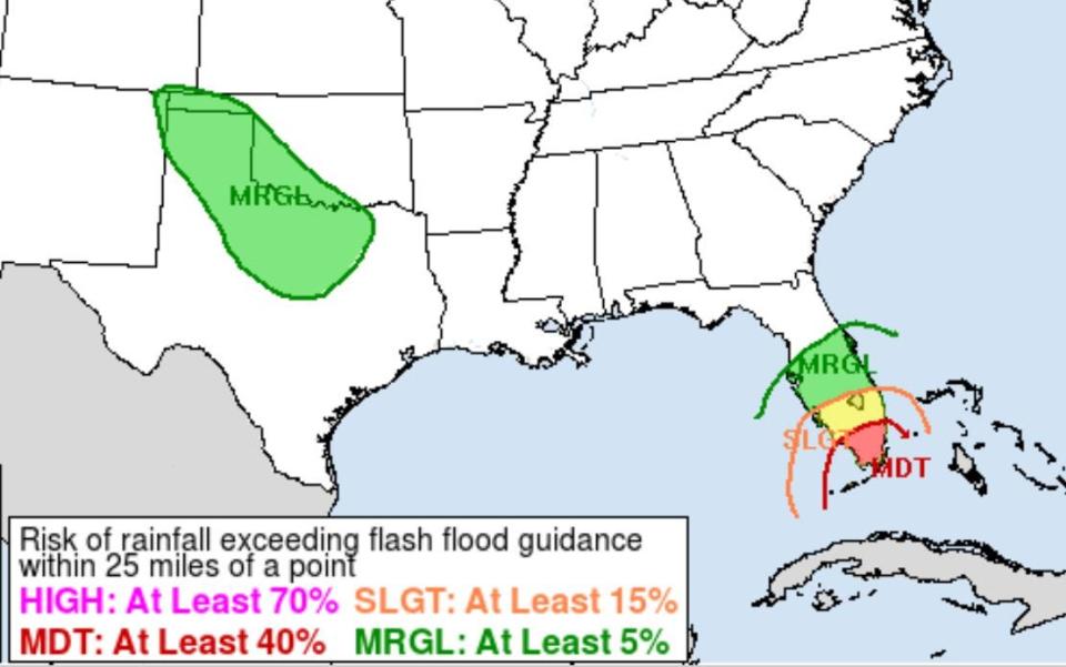
The Weather Prediction Center is forecasting the heaviest rains for Miami-Dade, Broward, Collier and Monroe counties, which are under a moderate risk for excessive rain that could lead to flash flooding. That means flooding that begins within three to six hours of heavy rainfall. A moderate risk is the third-highest on the center’s four-level scale.
Palm Beach County is under a slight risk for excessive rain, which is the second-highest level on the scale.
Hurricanes, typhoons, and cyclones: What’s an invest and why do they keep saying tropical cyclone?
Hurricane Sally: Storm's stall was calamitous for Gulf Coast; will slow-moving storms be a trend?
Larry Kelly, an NWS meteorologist in the Miami office, said the last time he could remember a moderate risk for excessive rain being issued was for Tropical Storm Eta. Eta made landfall Nov. 8, 2020, on Lower Matecumbe Key. It brought nearly 18 inches of rain in a 48-hour period near Pembroke Pines. In Palm Beach County, rain estimates from Eta ranged from 3 inches in Lantana to nearly 7 inches in Sandalfoot Cove in west Boca Raton.
“We’re looking at a first kind of ‘hello, how are you’ band of showers from this system early Friday morning before sustained rain comes in later in the afternoon,” said NWS meteorologist Anna Torres-Vazquez.
A trough of low pressure is guiding what was dubbed Invest 91L on Wednesday with the winds also making it a lopsided system, so its rainiest area is focused in its northeast quadrant.
Colorado State increased storm season forecast to well above average
While South Florida braced for its first tropical disturbance, Colorado State University increased its hurricane forecast Thursday to call for a well above-average season.
The update to the April 7 forecast added one named storm for a total of 20. A normal hurricane season has 14 named storms. Of the 20 named storms, 10 are forecast to reach hurricane strength with five becoming major hurricanes of Category 3 or greater.
This article originally appeared on Palm Beach Post: National Hurricane Center watches disturbance trying to become Alex

