South Plains, Big Country could see baseball-sized hail, 80 mph winds Monday evening
A severe weather system forecast to move through West Texas and Eastern New Mexico Monday evening is expected to bring baseball-sized hail, 80-mph winds and a chance for tornadoes, according to National Weather Service forecasts.
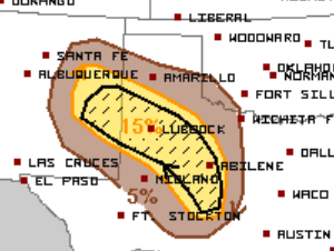
Lubbock, Abilene, San Angelo and Clovis, N.M. sit within an area NWS forecasters predict will see a 15% chance of "significant, severe" hail and wind into the late afternoon and evening hours, with stones in excess of 2 1/2 inches and gusts up to 80 mph. Amarillo, Midland-Odessa and Hobbs, N.M. will see a smaller chance for severe hail and wind up to 5% before storms push off to the east overnight.
Abilene and San Angelo could also see a higher chance of excessive rainfall and flash flooding after 9 p.m., with marginal chances of localized flash flooding throughout West Texas.
NWS also predicts a slight possibility of tornadoes, up to a 2% chance, for the South Plains, Big Country and Concho Valley. Lubbock, Plainview, San Angelo and Abilene are included in that forecast.
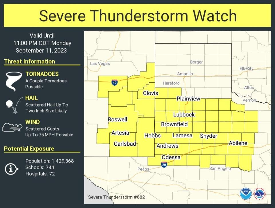
Just before 4 p.m., the National Weather Service issued a severe thunderstorm watch for most of the South Plains, Big Country and Eastern New Mexico, including Lubbock, Abilene, Midland-Odessa, Clovis, N.M. and Hobbs, N.M., but excluding San Angelo and Amarillo. The watch is active until 11 p.m. CDT Monday.
This article originally appeared on Lubbock Avalanche-Journal: South Plains, Big Country could see damaging hail, wind Monday evening

