SouthCoast residents warned to avoid wooded areas during Monday's high winds: Live
All of Eastern Massachusetts was on warning for high winds Monday after the SouthCoast woke up to dark skies, rain and high winds that had begun knocking down trees and power lines in the early morning hours.
In its warning, the National Weather Service said to expect south winds of 30-40 mph, with gusts up to 60 mph in a number of areas, including Bristol and Plymouth counties.
The warning was set to be in effect until 7 p.m.
"Damaging winds will blow down trees and power lines," NWS' warning read. "Widespread power outages are expected. Travel will be difficult, especially for high profile vehicles.
"People should avoid being outside in forested areas and around trees and branches. If possible, remain in the lower levels of your home during the windstorm, and avoid windows. Use caution if you must drive."
New Bedford closes several outdoor destinations; School let out early
According to New Bedford Public Information Officer Holly Huntoon, Monday's weather prompted the city to close the CoveWalk and HarborWalk walking paths and Fort Taber.
Winslow Elementary School in the city's West End was dismissed at 11:20 a.m. due to a power outage, Huntoon said. The hurricane barrier was also closed.
Westport closings
According to the Westport Fire Department, East Beach Road remains closed on Tuesday, as well as access to Gooseberry Island. They are asking that you avoid the area so that the Highway Department can continue clearing the roadways.
NBFD had a busy day
New Bedford Fire Chief Scott Kruger said on Tuesday that firefighters had gone out on 64 total responses during and in the aftermath of the unexpectedly severe weather. Of those, 32 are categorized as directly "storm-related," Kruger said, although adding that might be considered a subjective term.
"We were seeing a bunch of car accidents, so you could say they were storm-related," he said.
"It's crazy but what happened yesterday was actually worse than some of the named storms we've had."
Despite the added call volume brought on by the weather Monday, Kruger said NBFD managed through without adding any extra staff. In utility-related incidents, Kruger said New Bedford Emergency Management Agency members stood by at utility-related incident scenes while Eversource crews worked through lengthy delays to respond.
"EMA was very helpful with regards to that," Kruger said. "That frees up fire apparatus to go on other calls."
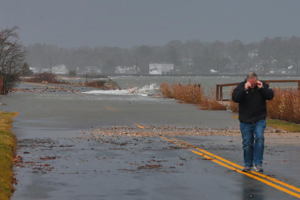
Dartmouth dealing with flooding
Over in Dartmouth's Fire District 1, encompassing South Dartmouth/Padanaram, Fire Chief Peter Andrade said it had been a busy day, noting he put on extra staff through Monday evening.
"I'd say we've fielded about 10-12 calls for service, which is way above normal for us," Andrade said Monday afternoon.
Andrade said activity included downed lines, flooding, and wave activity that caused the Padanaram Bridge to close in the morning.
"The bridge will only be in use for emergencies," he said, estimating it might open back up to general traffic by the evening.
Flooded areas within District 1 included Smith Neck Road near the old police station, and the area of Jones Park, Andrade said.
"I'd anticipate we'll get a lot of calls from down near Jones Park," Andrade said. "A lot of those people are at work but we took a ride down there and a lot of those houses are in a couple feet of water."

Fairhaven's West Island causeway gets splashed
Fairhaven Fire Chief Todd Correia said around town, there had been some flooding and downed wires, but "no major problems."
"There was some minor coastal flooding around the high-tide mark around 12 p.m. but nothing major," he said, noting the areas of Wilbur's Point and Weeden Road. Correia also noted some downed poles on Sconticut Neck Road near Orchard Street which Eversource was still on scene resolving Monday afternoon.
Fairhaven Harbormaster Timothy Cox said a high tide had waves splashing over the causeway to West Island; however as of about 12:45 p.m. he said things appeared to be subsiding.
"I think it's going down now [the tide] but the waves are crashing over the causeway right now," Cox reported after having just made the rounds to check up on some spots around town.
Cox said earlier in the day, the hurricane barrier being closed had delayed the passage of two vessels.
Ferry service canceled
Seastreak's website showed cancelations for all Monday ferry service between New Bedford and Martha's Vineyard.
"We apologize for the inconvenience," Seastreak's announcement read, directing those affected to contact customer service.
At New Bedford Regional Airport, Manager Scot Servis said there was nothing barring airlines from taking flight Monday, but as far as he'd seen, nobody had.
"When it comes to wind, it comes down to the pilot and what they think is safe," Servis said.
Thousands experience outages
The Standard-Times checked in with Eversource on the status of power outages in SouthCoast communities as of 11:30 a.m., and again at 2:40 p.m. By the afternoon, remaining outages in some communities had dropped while others had climbed since the morning.
Read the latest in Sports: 'A great opportunity': New Taunton boys basketball coach Santos hopes to improve each day
As of 11:30 a.m., outage totals were as follows: Acushnet, 81; Dartmouth, 1,213; New Bedford, 1,629; Fairhaven, 73; Marion, 273; Mattapoisett, fewer than three; Rochester, 679; Westport, 605.

As of 2:40 p.m., totals were: Acushnet, 100; Dartmouth, 744; New Bedford, 380; Fairhaven, 77; Marion, 326; Mattapoisett, 48; Rochester, 679; Westport, 131.
What to expect from the weather for the rest of Monday
The forecast is that peak wind gusts, along with heavy rain, will continue through early this afternoon, according to StormTeam 5. The wind will continue through the evening commute but the rain should have lessened.
StormTeam 5 will also be monitoring the midday and afternoon high tide for the potential for minor to moderate coastal flooding for south-facing beaches.
Areas near Narragansett Bay are under a coastal flood warning. Parts of Cape Ann, as well as the New Hampshire Seacoast and the southern Maine coast, may also experience coastal flooding during the mid-afternoon high tide.
What is the National Weather Service reporting for wind and rainfall totals?
The National Weather Service released the wind and rainfall reports as of 2 p.m. for Massachusetts. The “observations are collected from a variety of sources with varying equipment and exposures. … Not all data listed are considered official,” according to the service.
As of 2 p.m., Ashfield in Franklin County had the highest report with 4.8 inches.
Here are amounts reported in Bristol County:
S Lakeville: 2.34 inches as of 7:55 a.m.
Taunton Airport: 2.17 inches as of 1:26 p.m.
Dighton: 1.90 inches as of 8 a.m.
New Bedford Airport: 1.86 inches as of 1:42 p.m.
Rehoboth: 1.81 inches as of 7 a.m.
New Bedford: 1.73 inches as of 7 a.m.
Somerset: 1.73 inches as of 7 a.m.
Dighton: 1.70 inches as of 8 a.m.
Attleboro: 1.65 inches as of 8:19 a.m.
Norton: 1.64 inches as of 7 a.m.
Mansfield: 1.63 inches as of 6 a.m.
Westport: 1.60 inches as of 7 a.m.
NWS Boston/Norton: 1.45 inches as of 7 a.m.
Somerset: 1.31 inches as of 6 a.m.
Taunton: 1.29 inches as of 7 a.m.
Mansfield: 1.21 inches as of 5 a.m.
Westport: 1.16 inches as of 8:35 a.m.
Dartmouth: 1.10 inches as of 7 a.m.
Fairhaven: 0.85 inches as of 8 a.m.
Top Wind Gusts in Massachusetts
Here are the top wind guests in Eastern Massachusetts as of the 2 p.m. public information statement by the National Weather Service on Dec. 18.
Bristol County
Dighton: 66 MPH at 10:26 a.m.
Taunton Airport: 63 MPH at 11 a.m.
New Bedford Airport: 62 MPH at 10:34 a.m.
Norfolk County
Blue Hill Observatory: 90 MPH at 11:38 a.m.
Norwood Airport: 67 MPH at 10:35 a.m.
Weymouth: 63 MPH at 10:38 a.m.
Plymouth County
Plymouth Airport: 60 MPH at 9:15 a.m.
Marshfield Airport: 52 MPH at 12:55 p.m.
Hanson: 50 MPH at 11:58 a.m.
Suffolk County
Logan Airport: 68 MPH 10:53 a.m.
This article originally appeared on Standard-Times: High winds cause damage around New Bedford: What to know

