Southern Ontario faces dangerously foggy Christmas Eve, freezing drizzle

Santa will have to rely on Rudolph a little more when he visits southern Ontario on Christmas Eve as dense fog developing on Sunday night will persist across much of southern Ontario into Christmas Day.
A saturated air mass has enveloped all of southern Ontario, bringing the risk for freezing drizzle and dense fog over the next 24 hours. Fog advisories are speckled across southern Ontario on Christmas Eve, but could become more widespread Sunday evening.
DON’T MISS: What's your payout? El Niño brings Canada a holiday bonus
Dense fog is likely throughout southern Ontario—including the Greater Toronto Area (GTA)—overnight Sunday and into Christmas morning. Fog will persist into the day Monday before slowly dissipating as temperatures rise. More fog is possible again Monday night.
Driving in nighttime fog is an exceptionally dangerous task. If you don't have your own reindeer with a glowing nose, make sure to turn on your vehicle's fog lights and slow down when visibility is low.
Meanwhile, this moist pattern parked over the region for the holiday will also create freezing drizzle in spots. The risk for freezing drizzle is highest across eastern Ontario, including the Ottawa area.
Freezing drizzle will remain light and shouldn’t affect treated major roads, but slick conditions are possible on side streets, sidewalks, driveways, and steps. Fear not, kids—even though there will be an icy glaze on rooftops, it’ll be no match for Santa’s sleigh.
MUST SEE: Experts confirm huge B.C. blaze spawned a fire-generated tornado
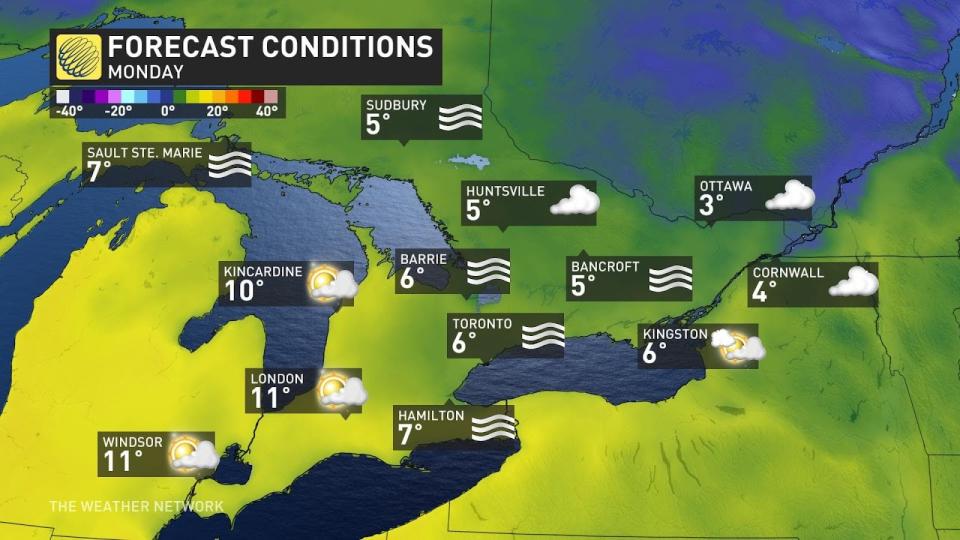
It’ll be an above-seasonal Christmas this year across southern Ontario as daytime highs climb into the double-digits for southwestern sections of the province.
A gloomy fog will keep temperatures a little cooler toward the GTA and into cottage country and eastern Ontario, with highs climbing into the mid-single digits.
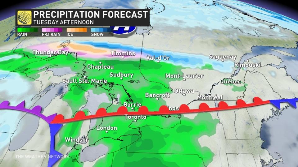
Our next system is a slow-moving low-pressure system arriving from the south. This will bring a potentially disruptive stretch of wintry weather into northern Ontario. Folks across southern Ontario will remain on the warm side of the storm, with rain and above-seasonal temperatures for Boxing Day on Tuesday.
Keep checking back with The Weather Network for more forecast information and updates on your weather across southern Ontario.

