Southern Quebec faces dangerous flooding risk through Monday

A vast reserve of tropical moisture parked over southern Quebec could lead to a risk for flash flooding on Sunday and Monday, with the greatest risk popping up during the day on Monday.
Use extreme caution while travelling through the region over the next couple of days. Do not try to drive or walk through floodwaters. Even a small amount of moving water can carry a person or vehicle downstream.
DON'T MISS: Get ahead of disaster: Six tips to manage flooding
We’re witnessing a classic flooding setup develop across New England and southern Quebec this weekend. An upper-level trough dipping over the region will provide ample lift to support widespread showers and thunderstorms over the region.
At the same time, a tremendous amount of tropical moisture streaming into the region from the south will boost precipitation totals. This moisture aloft acts like a reservoir that showers and storms can tap into and produce especially heavy rainfall rates.
Environment and Climate Change Canada (ECCC) has issued rainfall warnings for all of southern Quebec as rain that began on Sunday will only intensify as we begin the workweek.
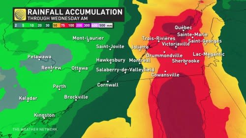
Rainfall totals of 50-75+ mm are likely across the Eastern Townships through Wednesday morning, with totals of 100+ mm possible in some localized areas. Folks across Metro Montreal could see 30-50 mm of rain through the first half of the workweek.
“The ground is near saturation locally and could have little ability to absorb these rainfall amounts,” ECCC said in its rainfall warning.
Current scene in West Point, New York / #HudsonValley 🌊The radar estimates that over 10 inches of rain fell today, nearly the amount that typically falls over an entire summer!⚠️ There's more rain to come...📸 Megan Cardone via a resident of West Point, NY pic.twitter.com/tLDVttp08p
Current scene in West Point, New York / Ben Noll on Twitter: "Current scene in West Point, New York / #HudsonValley 🌊The radar estimates that over 10 inches of rain fell today, nearly the amount that typically falls over an entire summer!⚠️ There's more rain to come...📸 Megan Cardone via a resident of West Point, NY pic.twitter.com/tLDVttp08p / Twitter" 🌊
The radar estimates that over 10 inches of rain fell today, nearly the amount that typically falls over an entire summer!
⚠️ There’s more rain to come…
📸 Megan Cardone via a resident of West Point, NY Ben Noll on Twitter: "Current scene in West Point, New York / #HudsonValley 🌊The radar estimates that over 10 inches of rain fell today, nearly the amount that typically falls over an entire summer!⚠️ There's more rain to come...📸 Megan Cardone via a resident of West Point, NY pic.twitter.com/tLDVttp08p / Twitter"
South of the border, the U.S. Weather Prediction Center (WPC) has issued a rare high risk for excessive rainfall on Monday across eastern New York state and Vermont, a risk area that extends right to the international border along Quebec’s Eastern Townships.
The WPC reserves high risk designations for days where forecasters are confident that heavy rainfall will lead to widespread and potentially destructive flash flooding.
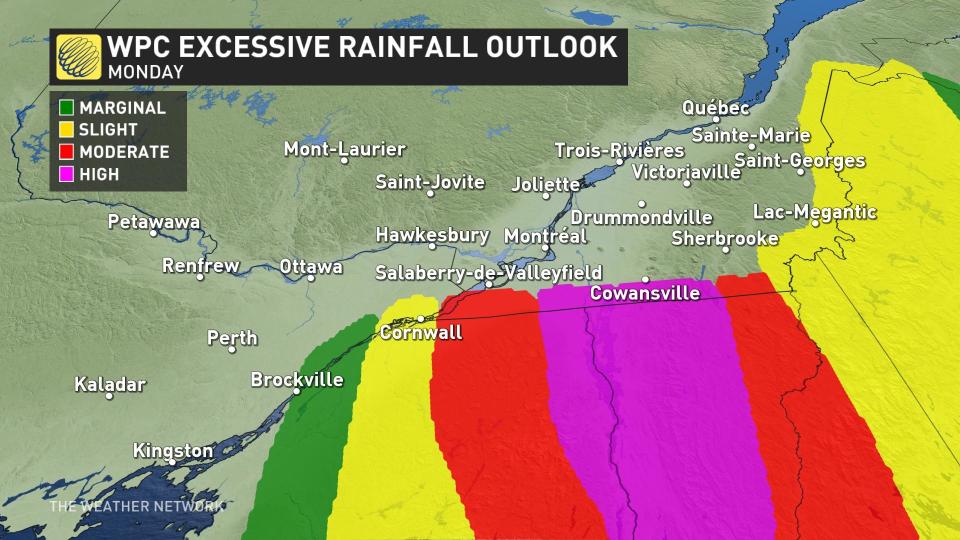
The agency’s statistics across the U.S. show that one-third of all flood-related deaths, and two-thirds of all flood-related damages, occurred within these high-risk areas between 2010 and 2020.
WPC forecasters had strong words for residents of northeastern New York and Vermont, just south of the international border.
“As everything continues to play out largely as expected, there are likely to be scattered Flash Flood Emergencies declared, along with mudslides and widespread flash flooding of not only small creeks and streams, but also the larger rivers,” the WPC said.
The American agency added: “The widespread flooding is expected to be analogous to the 2011 Irene remnants event for this area, though this time no tropical storms are associated with this rainfall.”
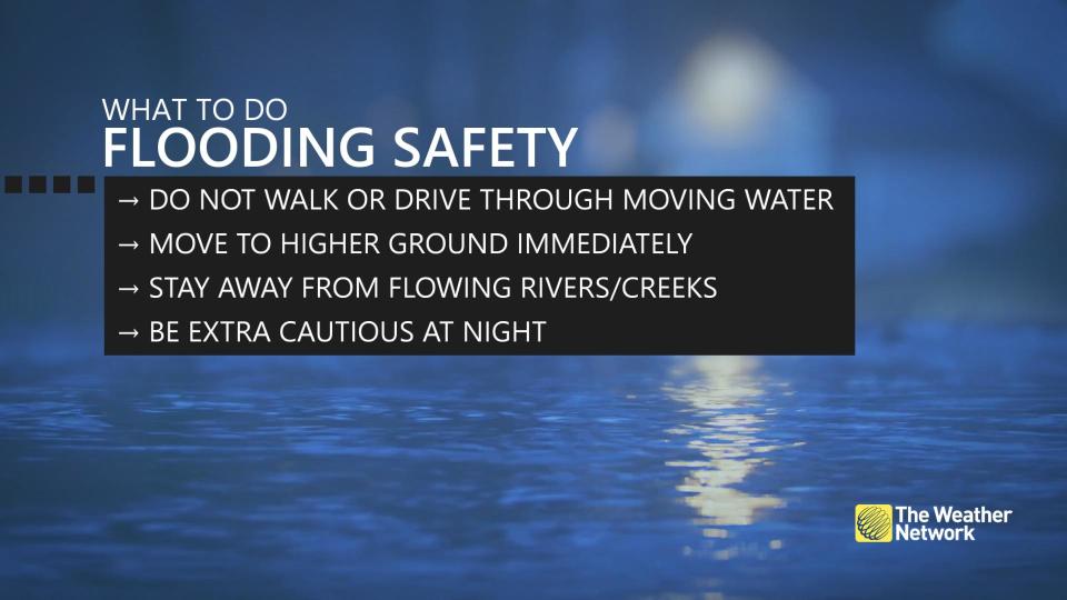
Flash flooding is one of the deadliest weather disasters you're most likely to encounter. It only takes a small amount of moving water to lift up and sweep away vehicles and pedestrians.
RELATED: Dramatic rescue shows why you shouldn't drive in flood water
It's impossible to tell the depth of water covering a roadway until it's too late, and the potential for washouts may mean there's no longer a road underneath the floodwaters.
The heavy rainfall will enhance the risk for landslides in areas with rugged terrain. Recent rains already triggered one devastating landslide in Rivière-Éternité near Saguenay on July 1.
Stay with The Weather Network for the latest on the flood potential in Quebec.

