Major hurricane could hit Southwest Florida. Tropical Depression 9 track ticks west
UPDATE: Ian now a named tropical storm. See the latest 11 p.m. Saturday forecast here.
The Tampa Bay area, including Bradenton and Sarasota, could be in the path of a major hurricane early next week, the National Hurricane Center’s 5 p.m. Friday forecast shows.
Tropical Depression 9 is likely to quickly strengthen into Tropical Storm Ian by Friday night, and it is expected to reach the Florida coast as a Category 3 hurricane late Tuesday night or early Wednesday morning.
While forecasters first expected the storm to become Hurricane Hermine, a different tropical system near Africa strengthened first and took that name on the list of named storms.
After Air Force Reserve Hurricane Hunters gathered data on the storm Friday morning, the Hurricane Center increased the expected intensity at landfall to 115 mph winds, which is a Category 3 storm. But in an update Friday evening, weather officials said their data missed the center of the storm and a Hurricane Hunter aircraft is again on the way to investigate the cyclone.
According to the latest forecast, the storm could make landfall as a major hurricane in Southwest Florida around 2 p.m. Wednesday.
The storm is forecast to rapidly intensify over the Caribbean, cross over parts of the Cayman Islands and Cuba, then further intensify in the warm waters of the Gulf of Mexico.
‘Don’t panic’
The track changed overnight Thursday because a center of circulation was found. Both major forecast models are now mostly in agreement, but there is still a lot of uncertainty on the exact path the storm will take.
“Don’t panic, we are still in the early stages of this event,” Acting NHC Director Jamie Rhome said in a livestream update Friday afternoon.
But everyone in the southern half of Florida should be prepared to feel the effects of a tropical system and prepare for a power outage, forecasters warn.
“You really need to start going through your hurricane supplies ... make sure you have everything that you need on hand.”
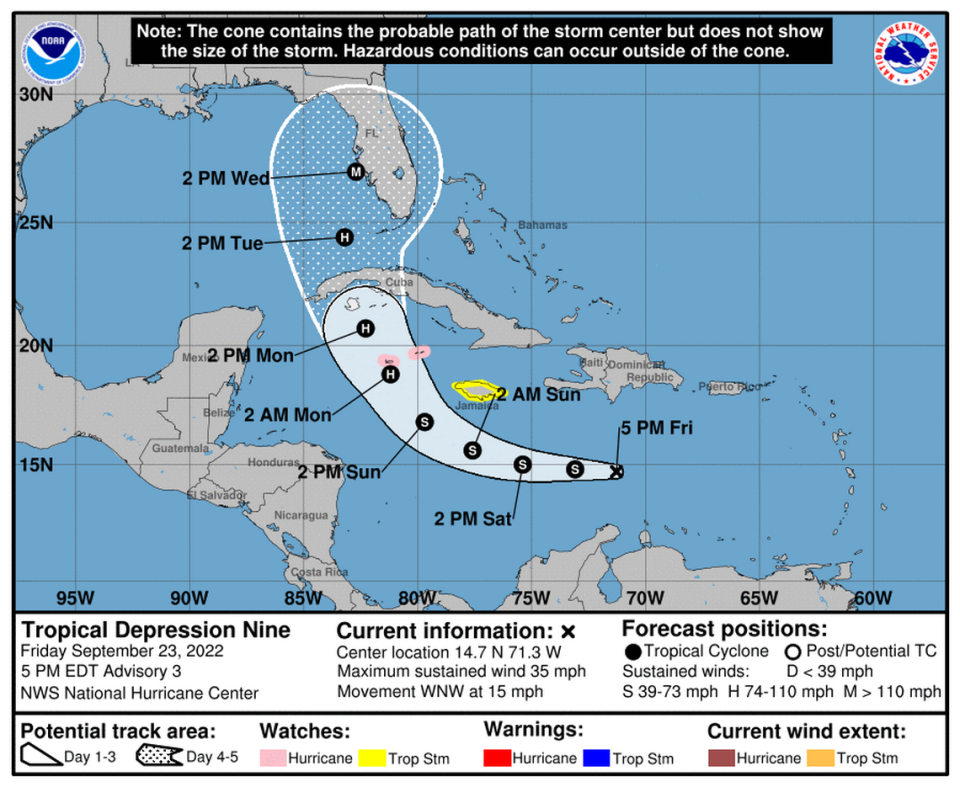
On Friday afternoon, Gov. Ron DeSantis declared a state of emergency for 24 Florida counties, including Manatee and Sarasota. The declaration makes state resources and funding for “emergency protective measures” available to areas that could be impacted by the storm.
In a statement, the governor urged Floridians to pay close attention to the storm and brace for impact.
“This storm has the potential to strengthen into a major hurricane and we encourage all Floridians to make their preparations,” DeSantis said. “We are coordinating with all state and local government partners to track potential impacts of this storm.”
When will it turn west?
As the storm continues to organize, the forecast models will be able to better predict the track.
The exact landfall also will depend on when the tropical system makes a turn to the north after heading west-northwest through the Caribbean.
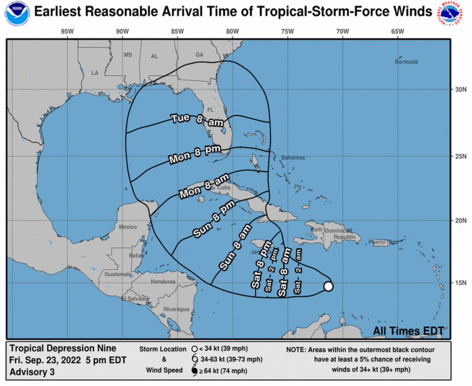
Tropical Depression Nine has formed in the Central Caribbean Sea. There is still a lot of uncertainty with the forecast for early next week, and the track could change significantly. Continue to monitor the forecast for updates. pic.twitter.com/R1JPklpuZc
— NWS Tampa Bay (@NWSTampaBay) September 23, 2022
“If the hurricane makes the northerly turn earlier than expected, Miami could be the target,” said longtime Gulf Coast forecaster Rocco Calaci. “If the hurricane makes the northerly turn later than expected, Tampa might be the target.”
The system is expected to move west through Saturday and turn north on Sunday and Monday.
“For those living in Southwest Florida, get ready because there isn’t much time before the projected landfall,” Calaci said.
Florida officials give hurricane planning advice
The Florida Division of Emergency Management is also monitoring the trajectory of the storm. As the storm approaches the state, officials recommend taking certain steps to keep your loved ones safe.
Make a disaster plan: If an evacuation is necessary, you should have a plan in place to determine where will you go in the event of a disaster.
Learn your flood zone: Do you live in a flood-prone evacuation zone? In Manatee County, you can use the Resident Information Tool by visiting www.MyManatee.org/information to learn key information about your address.
Sign up for alerts: Be sure to turn on notifications for news and local government agencies providing the latest information about the storm. Visit www.MyManatee.org/AlertManatee to sign up for phone call, text or email updates from public safety officials.
Keep your gas tank half full: Throughout the hurricane season, Florida’s public safety officials suggest keeping at least half a tank of gas in your vehicle, which could prevent having to worry about gas shortages or long lines in the days leading up to a storm.
Same crew, different system
Teal 71 is off to Tropical Depression Nine to collect data for @NHC_Atlantic forecasters this morning. #ReserveReady pic.twitter.com/UlM4Ze9KX9— Hurricane Hunters (@53rdWRS) September 23, 2022
5am AST 23 September--Tropical Depression Nine (#TD9) has formed in the central Caribbean this morning.
The Air Force Reserve Hurricane Hunters (@53rdWRS) will be investigating it later this morning to determine its latest structure & intensity.
Latest: https://t.co/sH2UrRpy71 pic.twitter.com/ErcYivwGMv— National Hurricane Center (@NHC_Atlantic) September 23, 2022

