SpaceX has made history again, this time by sending its first-ever recycled cargo ship to the International Space Station. This launch brings the aerospace company one step closer to making flights to space more affordable with reused rockets and capsules.
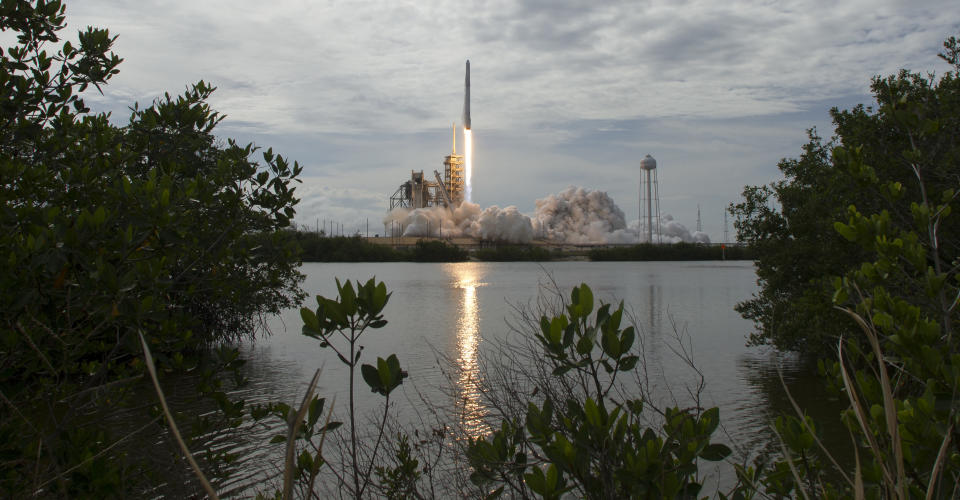
A Falcon 9 rocket launched the recycled Dragon capsule at 5:07 p.m. local time Saturday from the Kennedy Space Center in Cape Canaveral, Florida. Shortly after the first-stage booster launched the Dragon into orbit, it fell away from the capsule, flipped around, fired its engines and landed safely at the Cape Canaveral Air Force Station, according to Florida Today.
As ABC News pointed out, used rockets are now returned for a vertical touchdown as part of SpaceX’s efforts to lower the cost of flights. The booster launched Saturday likely will be used again.
The Dragon made its first trip to space in 2014, delivering food and supplies to the ISS, according to science news site Phys.org. It was refurbished after landing in the Pacific Ocean intact.
The SpaceX Falcon 9 rocket, with the recycled Dragon spacecraft onboard, launches from the Kennedy Space Center on June 3 in Cape Canaveral, Florida. (Photo: Bill Ingalls/NASA via Getty Images)
Saturday’s refurbished capsule will deliver 6,000 pounds of supplies to the ISS, including mice and flies to be used for research, a roll-up solar panel, food and a neutron star detector, according to NBC News. The flight had been delayed twice due to thunderstorms.
“It’s a pre-flown Dragon, and that is a pretty big deal too,” Hans Koenigsmann, SpaceX’s vice president of flight reliability, told Florida Today. “That lines up well with our quest to reuse [vehicles] and reusability, and overall in the long-term lowering the cost of access to space.”
The reused Dragon is expected to reach the orbiting lab on Monday. It will be the first returning craft since NASA’s now-retired shuttles.
CLARIFICATION: The headline and article have been updated to indicate, as originally reported further down in the piece, that this is SpaceX’s first recycled ship, not the first recycled ships ever used for space travel.
Also on HuffPost
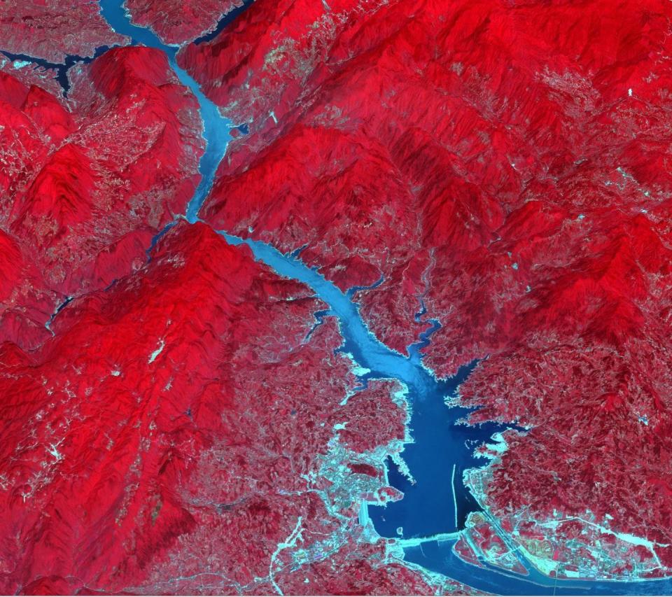
The Three Gorges Dam spans the Yangtze River in east-central China. It's the world's largest power station in terms of installed capacity, with its vast reservoir stretching for 410 miles.
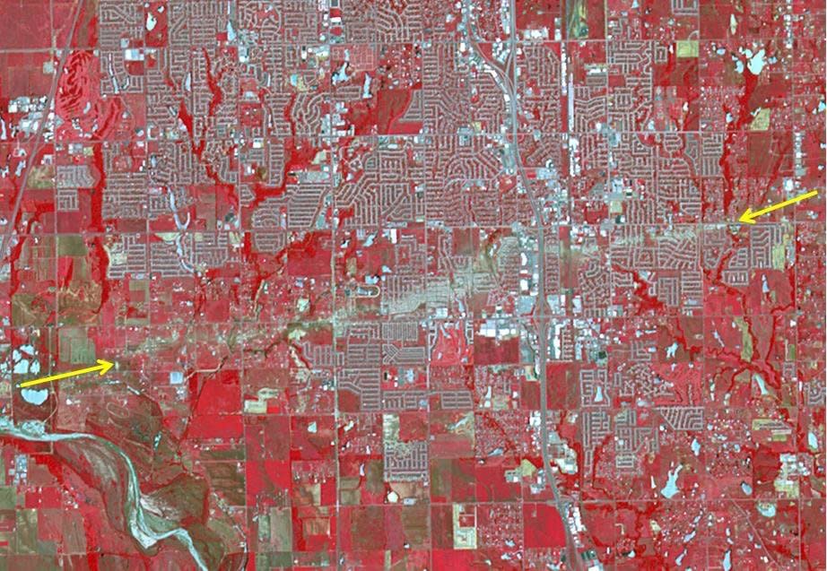
The Newcastle-Moore EF-5 tornado ripped through central Oklahoma on May 20, 2013, killing 24 people and leaving behind more than $2 billion in damage. On June 2, 2013, the Advanced Spaceborne Thermal Emission and Reflection Radiometer instrument on NASA's Terra spacecraft captured this image showing the scar left on the landscape by the tornado's deadly track. In this false-color image, vegetation is red, water is dark blue, roads and buildings are gray and white, and bare fields are tan. The tornado track crosses the image from left to right as indicated by the arrows. The image covers an area of 6 by 8.6 miles, and is located at 35.3 degrees north latitude, 97.5 degrees west longitude.
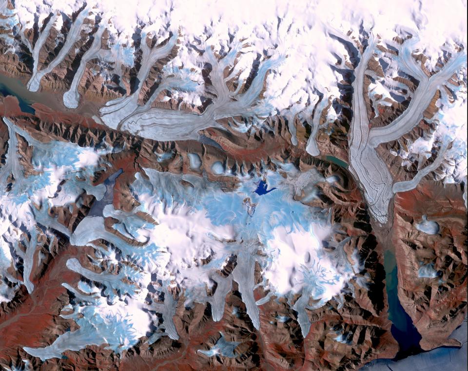
Ellesmere Island is part of the Qikiqtaaluk Region of the Canadian territory of Nunavut with the most northerly point of land in Canada. Inhabited since about 2000 BC, its current population is less than 200. Large portions of Ellesmere Island are covered with glaciers and ice, as seen in this image of a portion of the north-central part of the island.
In the middle of the Arabian desert, the city Green Oasis Wadi Al Dawasir is being developed as a new urban center for the Wadi Al Dawasir region of Saudi Arabia. Huge solar fields supply the entire city and the surrounding region with energy. Hundreds of circular agricultural fields are fed by center pivot irrigation apparatus, drawing water from subterranean aquifers.
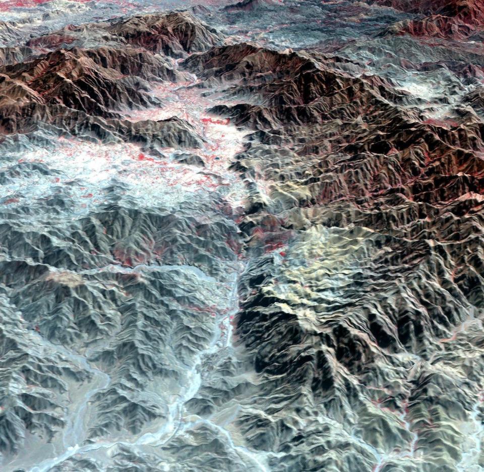
The Khyber Pass is a mountain pass that links Afghanistan and Pakistan. Throughout its history it has been an important trade route between Central Asia and South Asia, and is a strategic military location. It is the route used by Alexander the Great, Cyrus the Great, Genghis Khan, Babur the Tiger, Chandragupta Maurya, Darius I and countless other would-be conquerors. The Afghan Shinwari clan, who live in the Pass, regarded the Pass as their own preserve and have levied a toll on travelers for safe conduct. The perspective view looks from Afghanistan, eastward into Pakistan.
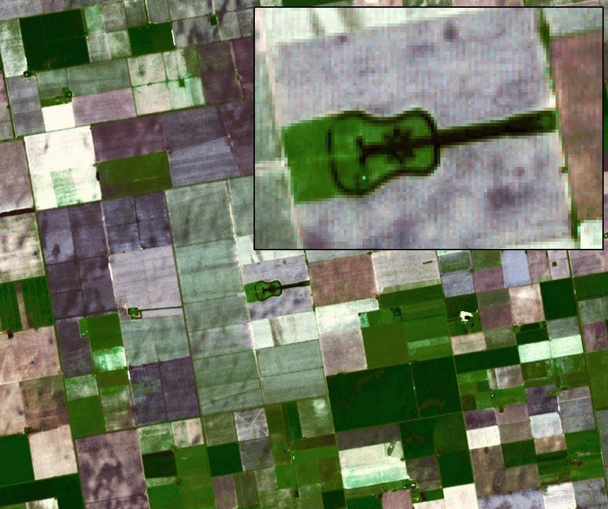
Located in the fertile agricultural region of Argentina's Pampas is a guitar-shaped forest made up of cypress and eucalyptus trees. An Argentinian farmer planted the forest in memory of his departed wife.
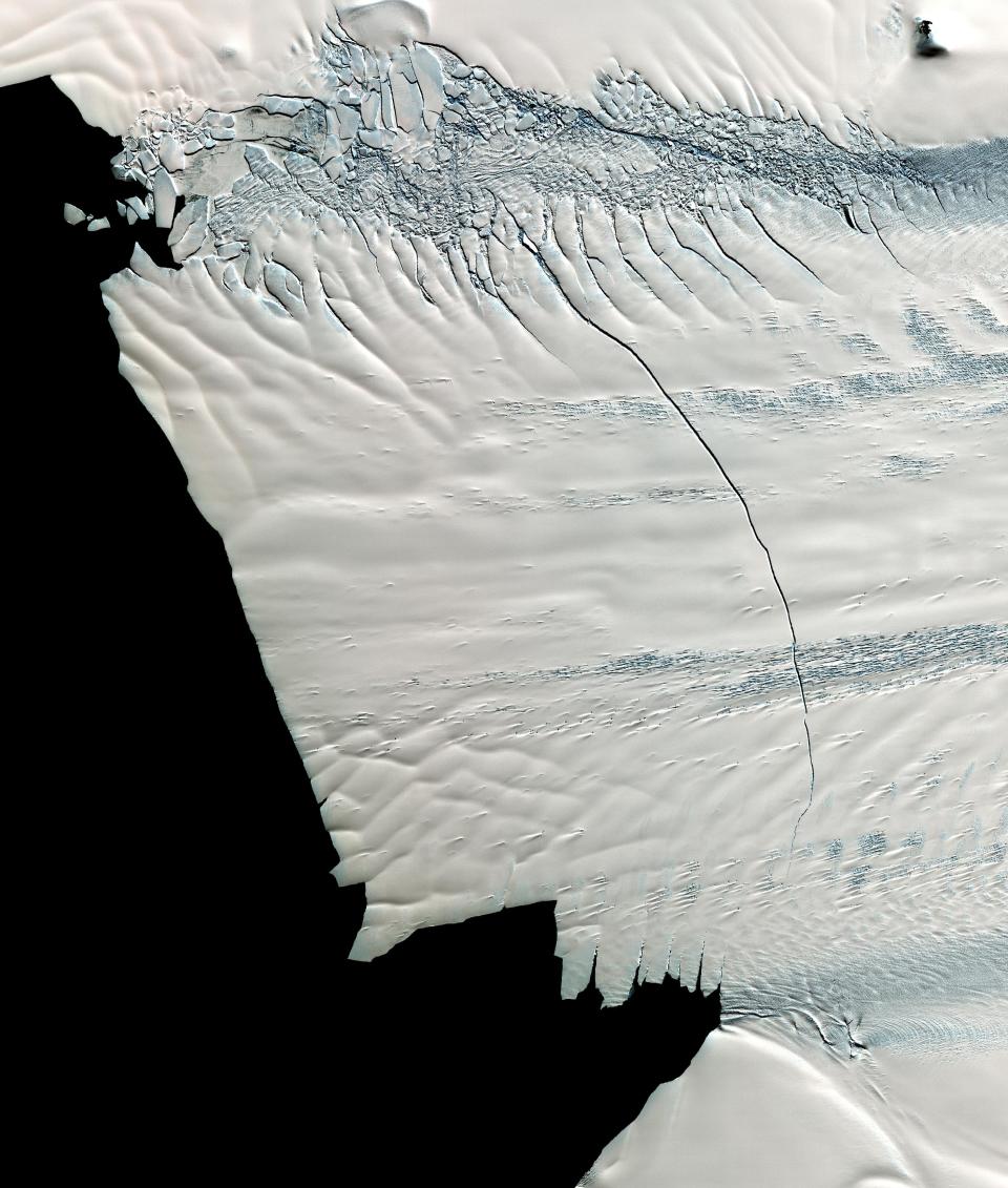
In mid-October 2011, NASA scientists working in Antarctica discovered a massive crack across the Pine Island Glacier, a major ice stream that drains the West Antarctic Ice Sheet. Extending for 19 miles, the crack was 260 feet wide and 195 feet deep. Eventually, the crack will extend all the way across the glacier, and calve a giant iceberg that will cover about 350 square miles. This image from the ASTER instrument on NAS's Terra spacecraft was acquired Nov. 13, 2011 and covers an area of 27 by 32 miles , and is located near 74.9 degrees south latitude, 101.1 degrees west longitude.
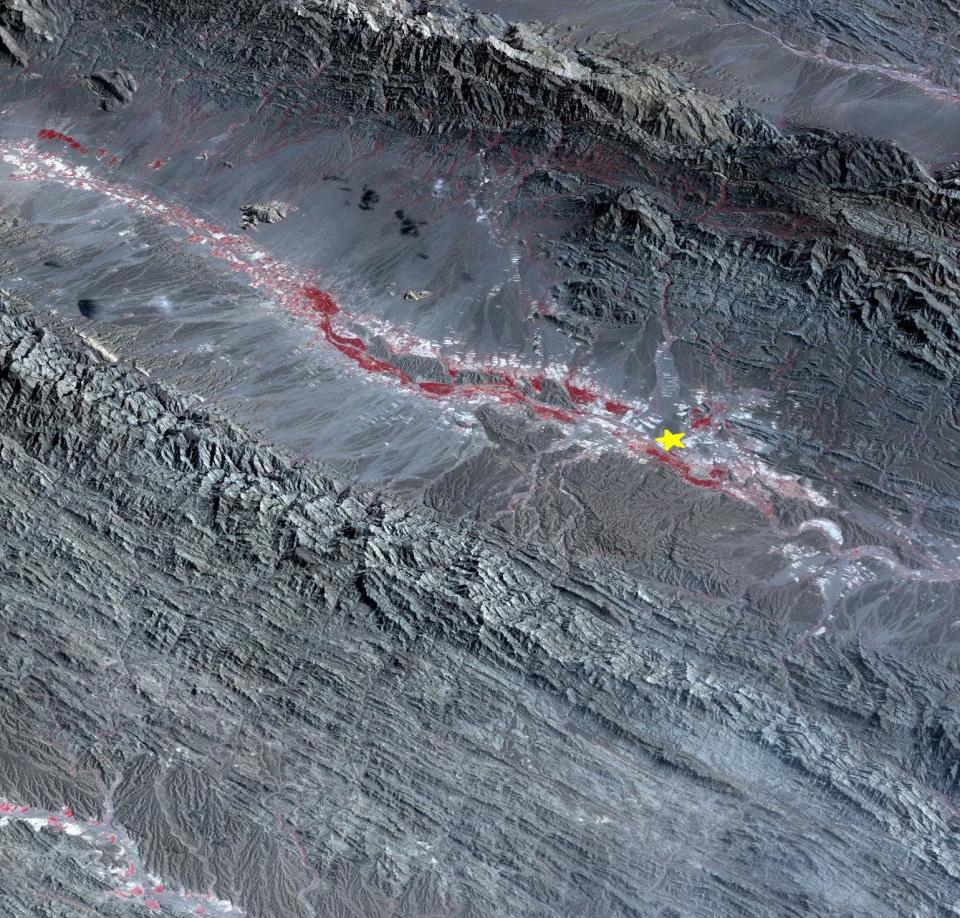
On September 24 at 6.29 a.m. ET, a magnitude 7.7 earthquake struck in south-central Pakistan at a relatively shallow depth of 12 miles. The earthquake occurred as the result of oblique strike-slip motion, consistent with rupture within the Eurasian tectonic plate. Tremors were felt as far away as New Delhi as well as Karachi in Pakistan. Even though the immediate area to the epicenter is sparsely populated, the majority of houses are of mud brick construction and damage is expected to be extensive. The perspective view, looking to the east, shows the location of the epicenter in Pakistan's Makran fold belt.
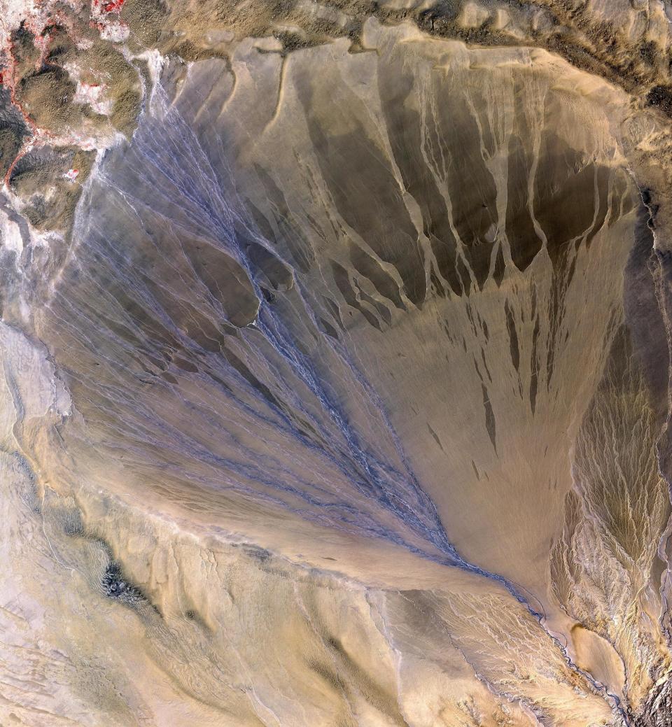
A vast alluvial fan blossoms across the desolate landscape between the Kunlun and Altun mountain ranges that form the southern border of the Taklimakan Desert in China’s XinJiang Province. The left side is the active part of the fan, and appears blue from water currently flowing in the many small streams.
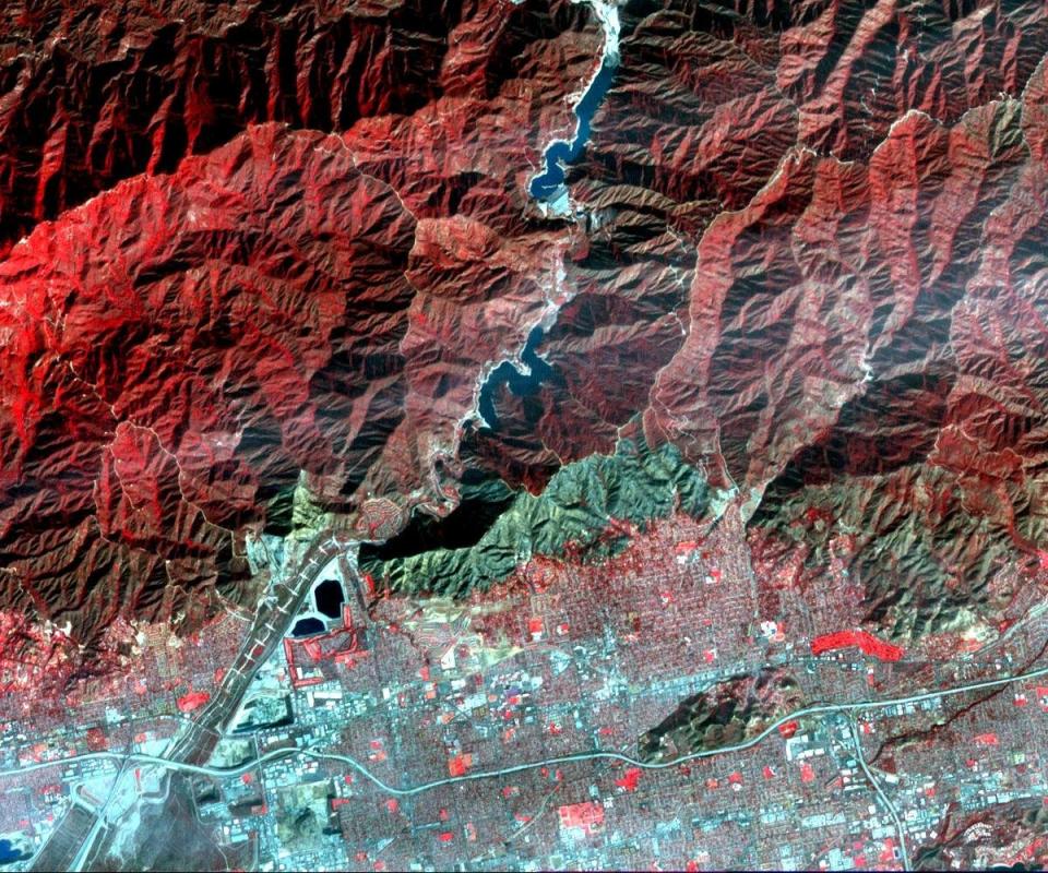
On Jan. 16, 2014, a wildfire broke out in the mountains above the Los Angeles suburbs of Glendora and Azusa. The fire consumed almost 2,000 acres and destroyed several homes, after starting from an illegal campfire. This image, acquired Jan. 23, 2014 from the ASTER instrument on NASA's Terra spacecraft, depicts vegetation in shades of red. The burned area is seen as the blue-gray area at the base of the mountains.
Poyang Lake was once China's largest freshwater lake. It has largely evaporated because of drought and a nearby dam on the Yangtzee River.
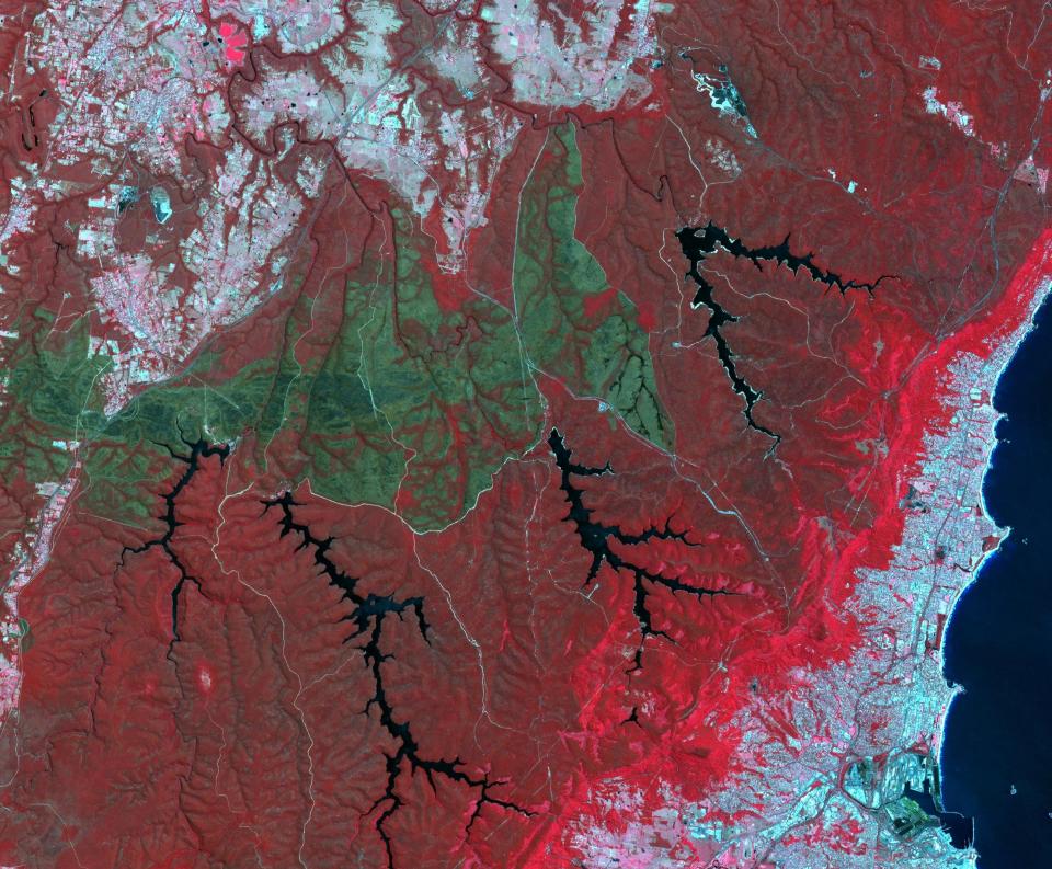
October 2013 brought the worst fires seen in the Australian state of New South Wales in many decades. More than 100 wildfires burned. One of the largest was the Hall Road fire, southwest of Sydney, west of the town of Wollongong. The fire scar is seen in this satellite image acquired Nov. 14, 2013, by the ASTER instrument on NASA's Terra spacecraft. Vegetation is displayed in shades of red, burned areas are dark gray, water is black and blue, and urban areas are blue-gray.
Vanguard has long had a reputation for eschewing the random fees asset managers are known for. But as our contributing columnist Allan Sloan notes, the company has started charging what he calls chintzy fees.
Clark set the Indiana Fever’s franchise record for turnovers (10), shot 5-of-15 from the floor and struggled with the Connecticut Sun’s physical defense.
Yahoo Sports NBA draft expert Krysten Peek is back for another season of On the Clock with Krysten Peek. Krysten just spent the week in Chicago at the NBA Draft Combine and kicks off draft season joined by CBS Sports' Kyle Boone.
All five of these hitters were drafted highly in fantasy baseball leagues. So far, they have not lived up to their ADPs — and that's an understatement. Scott Pianowski analyzes.
LeBron James reportedly wouldn't join an NBA team who drafts his son Bronny. Previously, LeBron has said he wants to play his final season with his son.