Spain’s “Empty Mountains” Are the Vacation Destination We’re Dreaming of for 2021
While travel is still super limited, most of us are stuck daydreaming about the next time we’ll get to ride somewhere other than our local loops. If you’re feeling the wanderlust too, check out the excerpt below from Lonely Planet’s new book Epic Bike Rides of Europe that’s got us planning a trip for 2021.
Sharing stories with fellow cyclists is one of the many charms of exploring by bike. The motivations and plans are inspiring—and can provide an endless source of ideas for trips of your own. Before long, it becomes clear that we’re all searching for similar things in our bikepacking experiences: adventure, wild nature and a sense of remoteness. It was shortly after this realization that the idea for the Montañas Vacías (Empty Mountains) route hit me.
Nestled deep within Spain’s eastern interior lies a far-reaching mountainous region known as Serranía Celtibérica. Twice the size of Belgium and occupying around 13% of the country’s total footprint, it boasts vast landscapes and high peaks, made all the more dramatic by its incredibly sparse population. In certain areas, there’s just one person for every square kilometer. A figure similar to that of the equally sparse Finnish Lapland – giving rise to Serranía Celtibérica’s unofficial nickname, the Spanish Lapland. Teruel, the high-altitude town I call home, could be considered Serranía Celtibérica’s centre. It’s the perfect launch pad to discover the surrounding mountainscapes, and was my chosen start point for the 430-mile (700km) Montañas Vacías route I designed to showcase Spain’s most adventurous—and little-known—riding destination. From here, paved roads and human company rapidly recede, and the region’s wilderness begins to impose upon your senses.

STARRY NIGHTS
Serranía Celtibérica boasts some of the clearest skies in all of Europe. The population scarcity, coupled with a lack of flight paths crossing the region, makes for minimal light pollution and a night sky illuminated only by the stars. One of the best places to gaze is the Javalambre plateau, where a simple stone shelter provides the perfect setting for a night spent in the elements watching the stars.
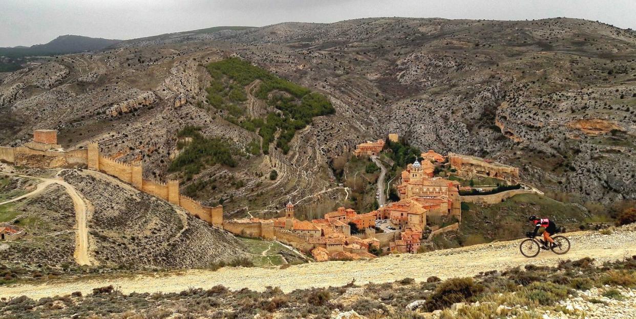
As you leave Teruel headed west in the direction of Sierra de Albarracín, the 17-mile (28km) long mountain range reveals its red cliffs, dotted with medieval villages and impressive viewpoints like the 4900ft (1500m) Peña de la Cruz. A short section of hike-a-bike on part of the Camino del Cid trail then draws you up above Albarracín for a breathtaking panorama of the village, one of Spain’s most beautiful, complete with its towering ancient walls. From here, the route enters the Alto Tajo Nature Reserve, home to the source of the Iberian Peninsula’s longest river, the Tagus.
This meandering forest stream belies the mighty body of water it will become, eventually stretching out over more than 625 miles (1000km) across Spain and into Portugal. The route hugs its banks on gravel tracks for the next 60 miles (100km) until, on its journey to the Atlantic, it bends westwards at Puente de San Pedro, where the opportunity for a farewell dip in its icy turquoise waters is too good to pass up.
Whether you choose to ride this route in five days or 15, traveling through the quiet hills and villages of the region has a profound effect. Soon you find yourself adapting to the rhythms of the territory’s people, scarce though they may be. Pack a little Spanish and talk to them, ask about their customs, their traditions, their foods. I find that one of the best times to do so is during almuerzo, a heavy brunch usually taken mid-morning, consisting of a big sandwich, some olives, and a coffee. Most towns and villages in the region are brought to a standstill by almuerzo, which makes it the ideal time to catch the locals at their most conversational. Nor should you miss the opportunity to refuel, all the better to knock off those miles before lunch—and on into the province of Cuenca, to the heart of the Serranía.
Roe deer, wild boar, foxes and vultures outnumber human inhabitants by some margin here, and the region’s dense pine forests begin to rise up before you. Here, the remoteness of Spanish Lapland hits home: from Beteta to Beamud, there are no more options for replenishing supplies, with only a mountain refuge for respite should you need it.
There’s nowhere better to experience the appeal of a quiet bivouac. My favorite spot is a tiny stone structure atop the Collado del Buey, sitting at 5640ft (1720m), with no facilities beyond a roof and four walls. The first time I camped here I barely slept. Not for lack of comfort, but for the draw of the stars outside lighting up the night sky. Aside from the isolation and the ever-changing mountain climate, it’s the elevation that provides the biggest challenge—accumulating more than 42,500ft across the 430-mile journey. Until now, most of the climbing has been short, sharp inclines with little in the way of flat riding. But ahead lies the Pico de Peñarroya—our highest point at 6,653ft (2,028m). A perfect, albeit steep, gravel road leads to the summit, and rewards your efforts with unspoiled views across the neighbouring Maestrazgo region and the Sierra de Javalambre.
YOUR GUIDE TO THIS RIDE
Start/Finish Teruel
Distance 430miles (700km)
Getting there Fly or take the train to Valencia or Zaragoza, then catch a regional train (which allow bikes) to Teruel.
When to ride Spring and autumn. Summer can be punishingly hot, and winter is a little too like the real Lapland.
What to take A rugged adventure touring bike with at least 2-inch tires. You’ll need to be an experienced bikepacker if you’re riding the full route: take a comfortable bivvy set-up and enough water-carrying capacity to get you through those long sections without resupply points.
More info www.montanasvacias.com
From the dizzying heights of Peñarroya, our route begins its meander back towards Teruel, towards real life. We leave behind the ancient communities that we’ve passed through, many of which are suffering from the effects of depopulation. For while the quiet and peaceful villages serve as a beautiful backdrop for our bikepacking adventures, their cultures are disappearing. It is my hope that in establishing this route, we can turn the threats of depopulation into opportunities. We could see this land not as empty or without a future, but as a remote place worth visiting, that has all the isolation, intrigue, and adventure we usually search for in far-flung exotic cycling destinations.
Getting inspired? Check out the full book of Lonely Planet’s Epic Bike Rides of Europe, Epic Bike Rides of the Americas, and Epic Bike Rides of the World.

More Spanish Bikepacking Adventures
PIRINEXUS
Looking for your first bikepacking trip in Spain? Pirinexus is a 217-mile (350km) loop that takes riders from north Girona through both Spanish and French Catalonia, and along the Costa Brava, never straying far from ‘green ways’, rural gravel roads and low-traffic tarmac roads. Not as demanding as the Montañas Vacías, or as remote, this well-signposted loop is open to riders of all abilities. As you pass from village to village, be sure to take enough time to sample the local gastronomy: from the rustic to the very best restaurants (plenty of places in the region boast a Michelin star). Along the way, you’ll find campsites, hostels and other accommodation options—which add to the route’s simple and accessible appeal.
Start/Finish Girona
Distance 217 miles
More info www.viesverdes.cat/en/routes/pirinexus
BURRALLY
Continuing our theme of remoteness, you’re more likely to encounter a boar than a BMW on this 435-mile (700 km) adventure through Valencia. The route begins on the Mediterranean coast and heads inland as it proceeds south to the west of the city of Valencia. The region is incredibly mountainous and hosts the annual Burrally ride through its beautiful landscapes, including the Penyagolosa Natural Park, Sierra de Espadán, the Chera-Sot de Chera Natural Park, and the Canal de Navarrés. Dubbed as a challenge, not a race, this small event is limited to just 30 people, and is inspired by the Torino-Nice Rally. Taking anything from four to 10 days to complete, the route can be ridden throughout the year, but as temperatures soar here in summer, it’s often ridden as a winter getaway.
Start Vinaroz, Castellón
Finish Xàtiva, Valencia
Distance 435 miles (700km)
More info burrally.wordpress.com
CAMINO DEL CID
A dense network of trails crossing Spain from Burgos, about 150 miles (240km) south of Bilbao, to Alicante’s Mediterranean coast, the Camino del Cid follows the steps of Rodrigo Díaz de Vivar, also known as El Cid Campeador, a medieval knight from the 11th century. It’s the ideal starting point from which to plan your next Spanish cycling tour, and features alternative tracks for mountain bikes or touring bikes which are signposted across its entire length: around 869 miles of tracks and 1240 miles of roads. Experience the contrasting cultures of the myriad medieval villages and towns that dot the route, as you travel through the provinces of Burgos, Soria, Guadalajara, Zaragoza, Teruel, Castellón, Valencia and Alicante.
Start Vivar del Cid, Burgos
Finish Orihuela, Alicante
Distance 932 miles
More info www.caminodelcid.org
You Might Also Like

