Spectacular bay views and Colonial and tribal history at Mount Hope Farm: Walking RI
BRISTOL — The short, shaded, side spur gradually descended through an opening in the trees to a salt marsh on the shore of Church Cove.
The view was spectacular. To the southwest, the Mount Hope Bridge glistened in the early-morning sun. To the south, a powerboat droned across the cove, kicking up seaspray. To the southeast, Seal Island jutted out of the water, covered with white seagulls.
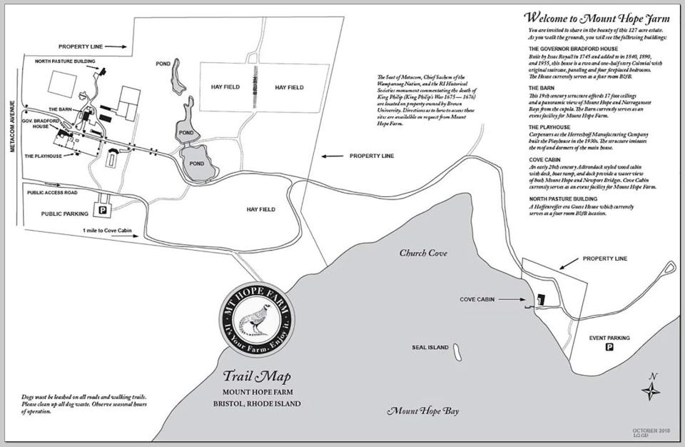
I found the sweeping vista while walking through Mount Hope Farm, the 127-acre property owned by the nonprofit Mount Hope Trust. The parcel of land, located on the eastern shore of Bristol, overlooks the part of Narragansett Bay known as Mount Hope Bay.
Walking RI: 5 great hikes with ocean views
Walking RI: Discover why hikers and anglers love the 'wild and scenic' Beaver River
Walking RI: Want to practice some rock climbing? Head to Connors Farm in Smithfield
For thousands of years, the wooded promontory was inhabited by the Pokanokets until the tribe was driven off the land by English settlers and farmers. The name “Mount Hope,” which refers to a 209-foot hill and the highest point in Bristol, is derived from the Pokanoket word Montaup, which means “rock shore” or “lookout place.”
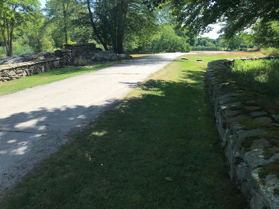
I set out to explore the farm — and learn some history — after parking in a lot behind a restored 19th-century barn topped with a glass cupola and a weathervane in the shape of a horse. I walked south along a stone wall on a path that circled historic farm buildings and then continued across a large mowed pasture to reach a paved road. I took it east down a long, gentle slope.
Walking RI: Leave the noise behind at a wooded retreat in Richmond
Walking RI: Follow in the footsteps of Trappist monks in Cumberland
After winding through a mixed forest, the shaded road flattened and passed a huge, golden-colored hay field on the left with milkweed, black-eyed Susans and other wildflowers growing at its edges.
Breathtaking views of bridge, boats and Seal Island
Further along the road, I passed a side trail and then took the next dirt path on the right. It led me south to the banks of Church Cove, with its stunning views of the bridge, boats, the island and houses in Portsmouth across the water. Under a clear blue sky, a wisp of a salty sea breeze blew from the cove across my face. It refreshed me.
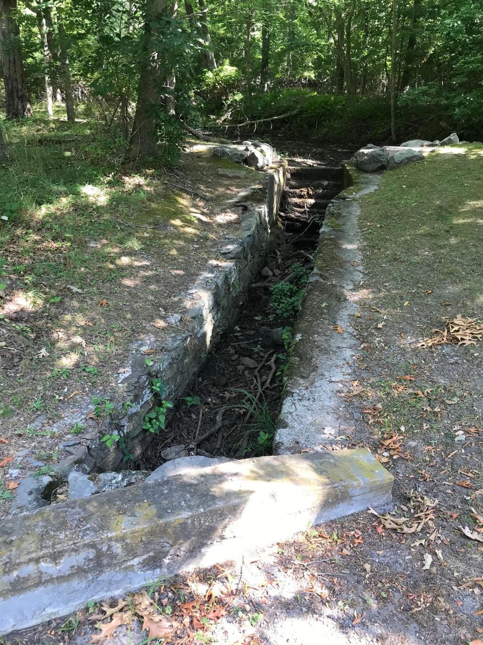
When I was done enjoying the scene, I returned to the main trail and headed north. I came to a junction and stayed right, passing several stone-lined channels built to carry runoff from the hillside through seasonal brooks to the Bay. Greenish, weathered plaques bolted to the stones told me the structures were built in 1939 by the federal Works Progress Administration (WPA).
Walking RI: 5 best family-friendly hikes around RI for nature lovers
Walking RI: Tillinghast Pond's trails are part of something special and well worth a visit
Walking RI: Trolley line left its mark at Lincoln's Lime Rock Preserve
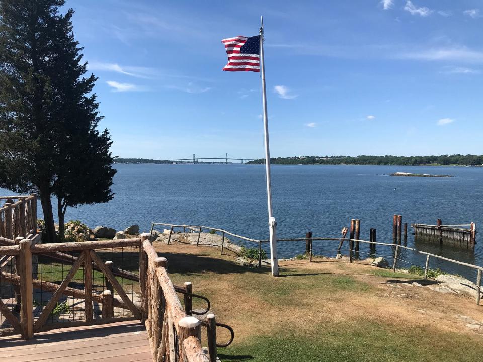
I followed the road to Cove Cabin, an Adirondack-style log structure built in the early 20th century by Rudolph Haffenreffer, an industrialist whose family once owned the Herreshoff Manufacturing Co. and the Narragansett Brewing Co.
The site is now used for weddings and special events, and I wandered by some huge white tents put up along a rocky shore with a cobble beach. An American flag fluttered in the breeze on a pole behind the cottage. Some wooden pilings just offshore may have once been part of a boat dock.
I rested under shady trees on a wooden bench overlooking the Bay and pulled out my binoculars to study the Mount Hope Bridge, completed at a cost of $5 million in 1929. You can see cars crossing the long, two-lane suspension bridge with 285-foot towers.
Walking RI: Mingle with birds, beavers, mink and more at Exeter's Fisherville Brook refuge
Walking RI: The haunting legacy of Tiverton's Fort Barton Woods
In the foreground, I spotted the smooth, rounded rock called Seal Island. Hikers report seeing harbor seals sunning themselves on the rocks in the winter and sometimes ospreys in the spring and blue herons in the summer.
As I looked at the hillside that runs down to the ocean and makes up Mount Hope Farm, I thought some more about its history.
Land was once home to Pokanoket Nation
The territory was once ruled by Massasoit Ousamequin, the great sachem of the Pokanoket Nation. He considered the land sacred and the tribe’s birthright.
After his death, one of his sons, King Philip, also known as Metacomet, led the Pokanokets, the headship tribe of about 60 clans, tribes and bands in the region. He made Mount Hope his base of operations during King Philip’s War (1675-1676), a brutal, bloody conflict that erupted with the English settlers.
Walking RI: Looking for a great birdwatching spot? Try this former Navy site in North Kingstown
Walking RI: A step-by-step guide to beautiful Stepstone Falls
Just to the northeast of the farm is King Philips’ Chair, a rocky quartz and granite ledge that spills out of the hillside. It was used for ceremonies and as a lookout for enemy ships on Mount Hope Bay. The private property is now owned by Brown University.
Also nearby is Misery Swamp, where Colonists shot and killed King Philip.
After his death, the remaining Pokanokets were enslaved, killed or driven off the land, and the prized property was claimed at various times by Plymouth Colony, Massachusetts Bay Colony, and Rhode Island. Eventually, the land passed through several owners, including the Church, Bradford and Haffenreffer families.
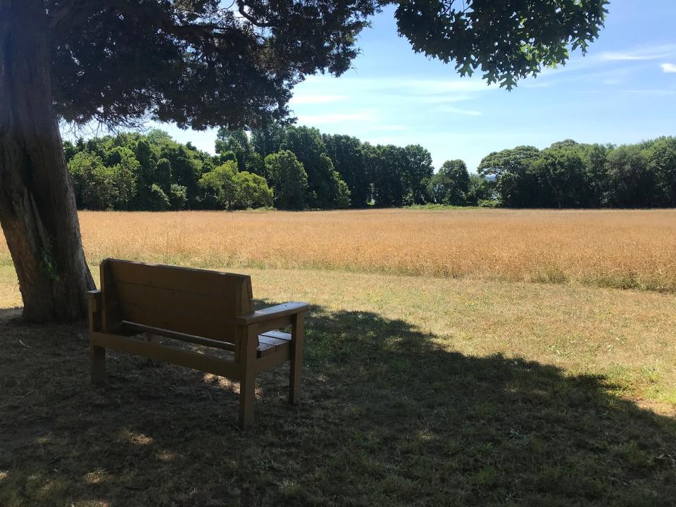
Today, the Mount Hope Farm property ends just east of the cabin, and after a long rest, a snack and some water, I decided to retrace my steps on the road. At the junction at the hay field that I had passed before, I went right and climbed a small hillside until I stopped at a bench under a tree on the edge of the field. Walkers report seeing rafters of wild turkeys here, and the tall grasses hide mice, moles, foxes, fishers and minks.
Walking RI: Best place for a hike and osprey spotting? Try the Great Swamp in South Kingstown
Walking RI: Trestle Trail in Coventry is a great spot for fitness training
A haven for birds in hayfields and ponds
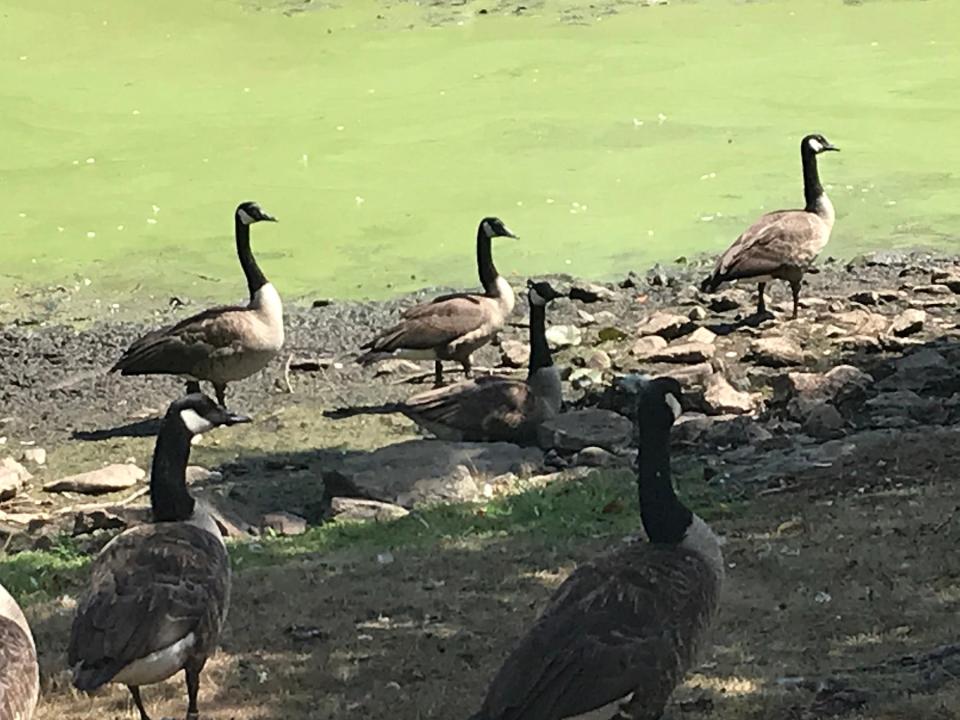
Continuing on the road, I took a side path on the right and found two more square- shaped hayfields that are sanctuaries for nesting birds, songbirds and wildlife. Just to the west, I walked by a series of three small ponds. Two of the ponds were covered with lily pads, cat-o'-nine tails, tall reeds and grasses while the third, lower pond was home to ducks, geese and a pair of swans.
I passed between two of the shallow ponds and found a cement spillway for water to drain from one to the other. But during this summer’s drought, there wasn’t a trickle.
Haffenreffer, who bought the farm in 1917, built a duck blind on one of the ponds. He also raised and released pheasants that he and his friends hunted. Hunting is no longer allowed on the property.
Walking RI: Retracing Thoreau's 1854 hike through Providence
Walking RI: Take in the fragile beauty of Warren's Touisset Marsh during a coastal hike
I learned later that Haffenreffer had expanded the network of ponds with the help of the WPA. It’s unclear why the public agency worked on private land.
Following the road, I passed lines of neat stone walls before returning to the lot where I started. I walked 2.5 miles over 90 minutes.
Several groups of youngsters had arrived in the meantime to visit the pens of chickens, dwarf goats and miniature donkeys. Others were playing tag on a hillside.
I decided to explore the complex of buildings, including a greenhouse, guest house, tool shed and groundskeeper’s house.
Walking RI: At Trustom Pond in South Kingstown, silence is golden
Walking RI: Coastal views and prime bird-watching at Tiverton's Emilie Ruecker preserve
George Washington slept here (really)
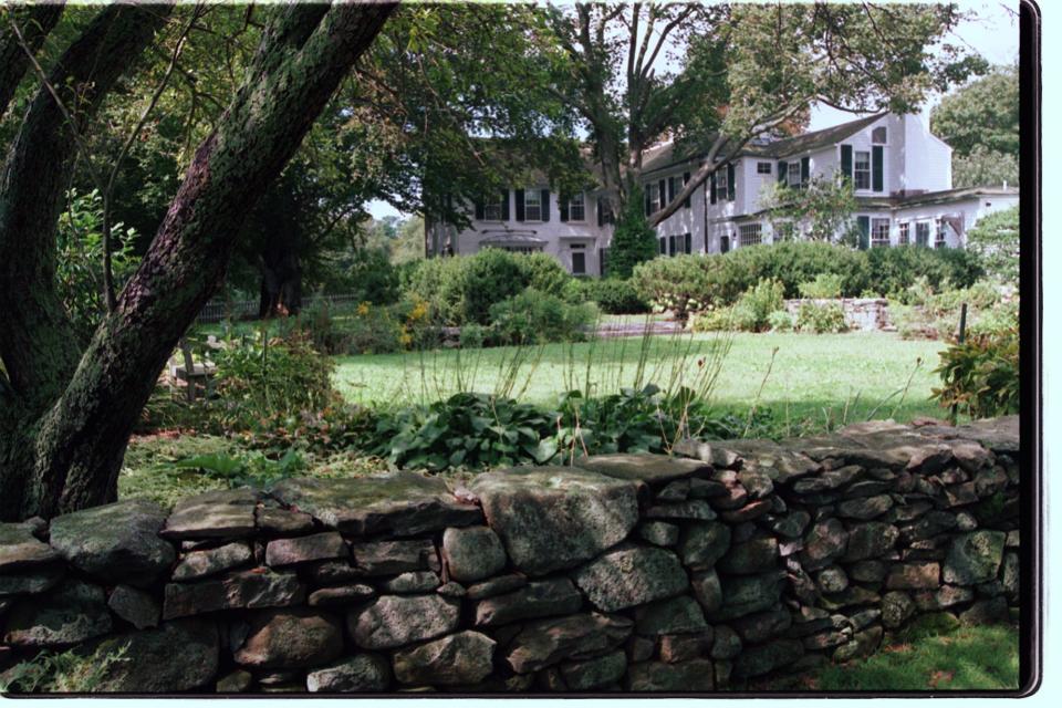
I paused at the Governor Bradford House, built by Isaac Royall in 1745. The house is named for William Bradford, the great-great grandson of Puritan Governor William Bradford and a former deputy governor of Rhode Island and U.S. senator. He lived on the farm and invited George Washington to spend a night there in 1790.
While circling the house, I noted the walled garden and unusual beech and sequoia trees before returning to where I had parked.
Walkers, joggers, families and visitors will find easy-to-follow roads and trails up and down hillsides and along the Bay at Mount Hope Farm. There’s also plenty of important history to learn along the way.
Walking RI: A birder's paradise by the shore in Middletown
Walking RI: Retracing an Aussie Walkabout in George Washington Management Area
Walking RI: Hollywood wow factor on Hopkinton trail
Trail Tip
The trails at Mount Hope Farm are open daily from 8 a.m. to 6 p.m., except on holidays.
A free walking tour app is available at the Apple App Store or Google Play. Search for Mount Hope Farm.
John Kostrzewa, a former assistant managing editor/business at The Providence Journal, welcomes email at johnekostrzewa@gmail.com.
This article originally appeared on The Providence Journal: Spectacular water views, rich history at Mount Hope Farm, Bristol RI

