Spring forecast looks snowy for some, AccuWeather experts say


Meteorological spring is right around the corner with the season kicking off on the first day of March, but for some areas of the country, the new season will bring more of the same with cold air, chances of snow and far-reaching winter storms.
About one month before the start of spring is the most well-known meteorological holiday of the year: Groundhog Day. Punxsutawney Phil declared six more weeks of winter after seeing his shadow on Thursday morning. But the groundhog's prognostication will not sway AccuWeather's spring forecast.
There will still be winterlike conditions to contend with across the United States, AccuWeather Senior Meteorologist Paul Pastelok said. "The AccuWeather long-range team is concerned about a surge of cold and wintry weather right near the official start of spring. Before then, it may feel like spring at times, particularly across the Southeast and mid-Atlantic."
 |
Groundhog Club handler A.J. Dereume holds Punxsutawney Phil, the weather prognosticating groundhog, during the 136th celebration of Groundhog Day on Gobbler's Knob in Punxsutawney, Pa., Wednesday, Feb. 2, 2022. (AP Photo/Barry Reeger) |
AccuWeather is not only calling for more waves of cold air throughout the spring but also the opportunity for snowstorms, severe weather outbreaks and previews of summer.
Will La Niña continue to shape the weather throughout the spring? Will gardeners get a jump start on the upcoming growing season? When will the first taste of warmth arrive? Find out the answers to these questions and more with AccuWeather's region-by-region spring forecast for the United States.
Winter has been a rollercoaster ride across the Midwest and Northeast that started with a blast of record-challenging cold right after the December solstice followed by spells of warm weather in January that made it feel more like April. A few mild days in February could make it feel like spring across the eastern U.S., but AccuWeather long-range forecasters say that winter coats and snow shovels may still be needed periodically after the first day of spring.
"Don't be fooled. There's still some winter left this season that may last into spring, and we could be talking about snow in March," Pastelok said. "And we may even see a little bit of snow in the Northeast in April."
Around the same time that meteorological spring begins, the polar vortex could shift again, similar to late January, sending a blast of bitterly cold air from the Arctic southward into the contiguous U.S. With cold air entrenched over the Midwest and Northeast, it will spawn the potential for some springtime snowfall.
 |
URUMQI, CHINA - FEBRUARY 17, 2022 - Snow-covered flowers are seen in Urumqi, Inner Mongolia, China, February 17, 2022. (Photo credit should read Costfoto/Future Publishing via Getty Images) |
Snow has been hard to come by across the Interstate 95 corridor, including in New York City which set a new record for the latest in the winter the city has gone without measuring at least 0.1 of an inch of snow. Boston is the only major city along the I-95 corridor where more than an inch of snow accumulated through the end of January, although the 7.9 inches that were measured was a fraction of the 24.2 inches that typically fall by the start of February.
March has the potential to be the snowiest month of the year for the big East Coast cities as a new weather pattern emerges at the start of spring.
"It is not uncommon to see nor'easters late in the winter or early spring," Pastelok said. "After a snowless early to mid-winter period for most, the Northeast can be at risk for one or two big storms with potential snow and wind."
Unusually warm water off the East Coast can help storms like nor'easters strengthen rapidly if they do form, increasing the potential for a high-impact storm in the mid-Atlantic and New England at the end of winter and during the first half of spring.
Even though the start of spring will bring the opportunity for more Arctic intrusions, the wintry conditions are not expected to last for weeks at a time.
"The pattern is gonna be up and down the rest of winter into the start of spring," Pastelok said.
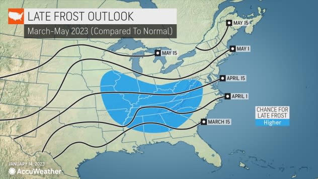
As frigid air retreats during the second half of spring, temperatures as a whole are likely to remain near or slightly below normal through May. As a result, folks who are planning to start a garden during the upcoming growing season could face setbacks. This is especially true across the southern Appalachians, the Ohio Valley, the Tennessee Valley, the mid-Mississippi Valley and parts of the Gulf Coast states.
"The potential for a late freeze in late March or April can lead to some damage," Pastelok said.
 |
The ingredients are coming together for another extended mud season across the eastern U.S., according to AccuWeather Senior Meteorologist Joe Lundberg. "An unfrozen ground, low evaporation rates and added rainfall to an already wet soil can lead to mud-filled fields in the East for much of the spring," Lundberg said.
Hikers, backpackers, dog owners and horseback riders should check the AccuWeather forecast and the latest trail conditions to properly prepare for potentially muddy conditions in the coming months.
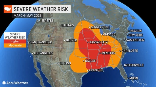
The start of 2023 has been hyperactive in terms of severe weather with 164 preliminary tornado reports in January, the second-highest on record for the month. The stormy start to the year is a preview of what's to come as the spring severe weather season arrives.
Severe weather could ramp up quickly in March with the potential for multiple outbreaks from the Gulf Coast to the Plains and potentially parts of the Midwest. However, the number of twisters is likely to be lower than last March when 233 tornadoes were reported throughout the month.
 |
Jeff Rogers talks on the phone while surveying damage around his home on Joyner Street in Tupelo, Miss., Tuesday, April 29, 2014. (AP Photo/Thomas Graning) |
The frequency of thunderstorms and tornadoes is not expected to keep up at this pace throughout the entire spring, providing a break to storm-weary areas of the central and southern U.S.
"There may be some lulls where we don't have a whole lot of severe weather in the Ohio Valley and the Tennessee Valley, especially the middle part of the spring," Pastelok explained.
A new weather pattern could take hold at the end of March or the start of April with cold, stable air spreading across most of the Plains and Midwest. This will not completely eliminate the risk of damaging storms and tornadoes, but it will reduce the potential for widespread, multi-day outbreaks.
As the calendar flips to May, so too will the weather pattern, once again opening the door for more widespread severe weather events from Mississippi to Minnesota and from the central Plains to the central Appalachians.
 |
Similar to last year, the worst of the severe weather is expected to occur outside of the traditional Tornado Alley, which stretches from Texas through South Dakota. One of the driving factors behind this is the long-term drought across the region.
"Drought last year put a lid on a lot of the severe weather for a while during the spring," Pastelok said. This was especially true in the High Plains where the most severe drought conditions were present.
Drought is still ongoing in the Plains, but a different weather pattern this spring will bring more opportunities for thunderstorms to Tornado Alley, which can lead to small improvements in the drought. Even though springtime thunderstorms will deliver much-needed rain, the drought is likely to persist into the summer.
GET THE FREE ACCUWEATHER APP
• Have the app? Unlock AccuWeather Alerts™ with Premium+
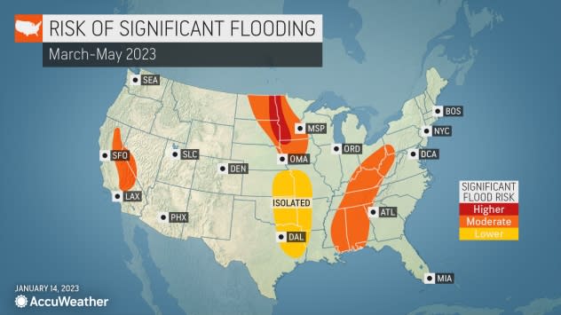
Farther north, the primary weather risk throughout the spring could be flooding rather than severe weather.
An abundance of snow has blanketed the northern Plains and Upper Midwest throughout the winter, including in Minneapolis where over 55 inches of snow accumulated through the end of January. Typically, only 30 inches of powder piles up in the Twin Cities by the start of February.
The widespread snowpack will limit the severe weather potential throughout the first half of the spring. As the snow melts, it will feed into the Red River watershed, increasing the risk of flooding along the river and its tributaries into the start of summer.
 |
Melting snow can also help to boost water levels on the Mississippi River. During the second half of 2022, the Mississippi River water levels were near record low levels, which impacted barge traffic and revealed ancient artifacts that were submerged for over a century. Water levels have risen in the middle and lower part of the basin since autumn following stormy weather.
More heavy rain events are expected from the Gulf Coast to the Ohio Valley throughout the spring which will continue to fill the Mississippi River, as well as raise the risk of flooding throughout the spring.
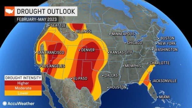
A barrage of storms pummeled the West Coast from late December through the first half of January, making significant headway in the drought across California -- and more drought relief could be coming to the West Coast as spring arrives.
"Things are looking pretty good right now. The drought has eased back a little bit," Pastelok said.
On the five-point scale used by the U.S. Drought Monitor, extreme and exceptional drought are the two worst classifications. Since the start of December, the exceptional drought has been all but erased across the West, and the areas facing extreme drought have been significantly reduced.
More storms are possible through the end of winter and into the spring for California, but most of the storms that flow from the Pacific to the U.S. are likely to focus on the Pacific Northwest.
 |
AccuWeather's drought forecast for the United States through May. (AccuWeather) |
Despite the improvement in the widespread drought conditions throughout the winter, the drought is far from over, and water restrictions could continue throughout most of 2023.
It's not just California where drought conditions improved but also the Colorado River basin which feeds into Lake Powell along the border of north-central Arizona and south-central Utah and Lake Mead along the border of western Arizona and southeastern Nevada.
In 2022, the water level of Lake Mead reached its lowest level since the reservoir was filled in 1937, revealing shipwrecks and human remains that were submerged for decades.
 |
A boat floats past bathtub rings showing how low Lake Powell levels have dropped Tuesday, June 7, 2022, in Page, Ariz. (AP Photo/Brittany Peterson) |
As the days grow longer and temperatures steadily rise across the interior West, snow that fell across the region's mountains throughout the winter will begin to melt and feed the tributaries of the Colorado River. Snowmelt is crucial during the spring and early summer as melting snow is the main water supply for rivers during a time of year that features very little rain.
"There is good snowpack in the mountains," Pastelok said. "I think that it will benefit Lake Mead and the other reservoirs in that region."
The snowmelt throughout the spring will be far from enough to fill Lake Mead and Lake Powell, but it will be a big step in the right direction. It will take several more stormy winters to erase the widespread drought in the West and to replenish water levels in crucial reservoirs across the region.
 |
As temperatures rise and mountain snow begins to melt, some cities across the West could receive their first taste of summer.
"We could start to see some really warm weather in the Southwest by mid- to late April," Pastelok said.
The summer previews could take time to arrive in Central and Northern California and across the Pacific Northwest where the ground is saturated from winter storms.
Pastelok added that there could even be some chances of rain in California in April and May. If this occurs, it will heighten the risk of flooding as rain paired with rapid snowmelt from the mountains could cause rivers to swell.
For the third winter in a row, La Niña had a significant influence on the storm track and overall weather across North America, but the "triple-dip La Niña" may soon come to an end.
La Niña is part of a regular climate pattern called ENSO that occurs when the water temperatures near the equator in the Pacific Ocean are lower than average. The cool waters can alter the jet stream patterns on a global scale and are a major factor when AccuWeather forecasters make long-term predictions.
But changes are on the horizon.
 |
"Right now we're still in La Niña, but it is weakening," Pastelok explained. "The water temperatures over the eastern equatorial Pacific are starting to rise."
If the water continues to warm, La Niña will end and ENSO will enter a 'neutral' state. If the warming trend persists, it could eventually lead to the formation of El Niño.
Some weather models are indicating that El Niño could quickly replace the fading La Niña, but Pastelok warns that it's still too early to say for sure due to something known as the spring predictability barrier.
"The thing is about this time of the year is coming out of the cold season, we don't get good initialization a lot of times into the weather models," Pastelok explained. He added that the models might get false readings, which could have a ripple effect on the long-term forecasts.
This puts up a metaphorical barrier for forecasters, making it more challenging to predict La Niña and El Niño beyond a few months.
 |
AccuWeather meteorologists gather to discuss the weather during a regular meeting at the AccuWeather global headquarters in State College, Pennsylvania. (AccuWeather) |
"When we get to May or June, things start to get much better in the modeling," Pastelok added. "We have a better understanding of what to expect going down the road."
If La Niña quickly transitions to El Niño before the end of the year, it can have a significant impact on the tracks of storms and the overall weather patterns across North America compared to the past three years when La Niña was the dominant force.
In a typical El Niño pattern, moisture often targets California and the southern tier of the United States due to an active storm track. When El Niño occurs during a hurricane season, tropical development can be suppressed in the Atlantic due to disruptive wind patterns that often occur over the ocean.
Want next-level safety, ad-free? Unlock advanced, hyperlocal severe weather alerts when you subscribe to Premium+ on the AccuWeather app.AccuWeather Alerts™ are prompted by our expert meteorologists who monitor and analyze dangerous weather risks 24/7 to keep you and your family safer.
