PHOTOS: Potent spring storm brings tornado watches, ice damage and heavy snow
From the first tornado watches of 2023 in southwestern Ontario, to heavy snow and blizzard-like conditions, which halted travel across southern Manitoba and parts of northern Ontario -- a sprawling and potent Colorado low made for a mess of a Wednesday across much of central and eastern Canada.
In eastern Ontario and southwestern Quebec, the heaviest impacts were felt in the form of prolonged freezing rain, with more than one million customers left without power in Quebec by the early morning hours on Thursday.
MUST SEE: More than 1 million without power as freezing rain coats southwestern Quebec
Conseil de #sécurité : si vous êtes témoin d'une situation dangereuse, comme des fils, poteaux ou autres équipements au sol, surtout gardez vos distances et appelez le 911. Nos équipes seront dépêchées sur les lieux afin de les sécuriser. pic.twitter.com/JDS40JbXkD
Conseil de Hydro-Québec on Twitter: "Conseil de #sécurité : si vous êtes témoin d'une situation dangereuse, comme des fils, poteaux ou autres équipements au sol, surtout gardez vos distances et appelez le 911. Nos équipes seront dépêchées sur les lieux afin de les sécuriser. pic.twitter.com/JDS40JbXkD / Twitter" : si vous êtes témoin d'une situation dangereuse, comme des fils, poteaux ou autres équipements au sol, surtout gardez vos distances et appelez le 911. Nos équipes seront dépêchées sur les lieux afin de les sécuriser. Hydro-Québec on Twitter: "Conseil de #sécurité : si vous êtes témoin d'une situation dangereuse, comme des fils, poteaux ou autres équipements au sol, surtout gardez vos distances et appelez le 911. Nos équipes seront dépêchées sur les lieux afin de les sécuriser. pic.twitter.com/JDS40JbXkD / Twitter"
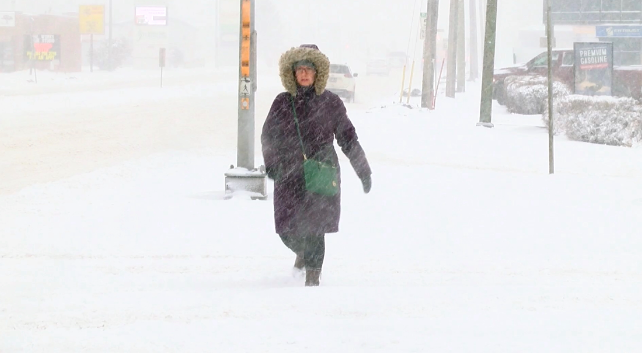
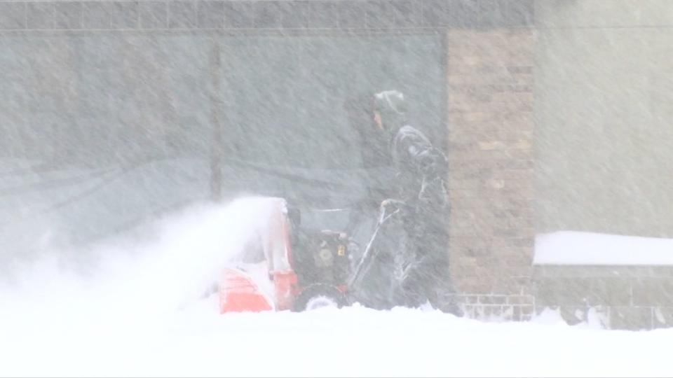
The far-reaching system moved into Manitoba Tuesday night, spreading snow across nearly the entire southern region, stretching west to well past the Ontario border through Wednesday morning.
The quickly accumulating snow made for a slow and sloppy morning commute, with totals exceeding 10-15 cm in some areas, including the city of Winnipeg before lunch-time. Heavier amounts of 20+ cm were forecast for regions in the southeast.
Heavy snow and winds whip through southern Manitoba. Courtesy: Chris D.
The snow coupled with gusty winds between 50-70 km/h made for significantly reduced visibilities for much of southern Manitoba, prompting the province to close some highways due to poor driving conditions caused by blowing snow.
The spring storm also brought high winds and heavy snow across northwestern Ontario, where 15-25 cm was forecast for the region. Wednesday's storm resulted in several school closures and school bus cancellations across northern Ontario, with drivers being urged to avoid any unnecessary travel.
Parts of southern Ontario saw the much warmer side of the system, with the Windsor reaching Canada's first 20°C temperature of the year. The city hit 20.5°C before noon. With the warmth came the instability however, fueling the threat for severe thunderstorms, which spanned the region at times. This storm system also prompted Canada's first tornado watch in 2023 in southwestern Ontario, and that covered the Windsor, Essex, and Chatham-Kent regions. The watch was dropped around 3 p.m., but heavy rain, hail and powerful winds were reported throughout the day.
A look at the shelf near Petrolia as it swept towards us. Quite the shelf for April. @weathernetwork #ONStorm pic.twitter.com/Pguh7J4Nge
A look at the shelf near Petrolia as it swept towards us. Quite the shelf for April. Mark Robinson on Twitter: "A look at the shelf near Petrolia as it swept towards us. Quite the shelf for April. @weathernetwork #ONStorm pic.twitter.com/Pguh7J4Nge / Twitter" Mark Robinson on Twitter: "A look at the shelf near Petrolia as it swept towards us. Quite the shelf for April. @weathernetwork #ONStorm pic.twitter.com/Pguh7J4Nge / Twitter" Mark Robinson on Twitter: "A look at the shelf near Petrolia as it swept towards us. Quite the shelf for April. @weathernetwork #ONStorm pic.twitter.com/Pguh7J4Nge / Twitter"
— Mark Robinson (@StormhunterTWN) Mark Robinson on Twitter: "A look at the shelf near Petrolia as it swept towards us. Quite the shelf for April. @weathernetwork #ONStorm pic.twitter.com/Pguh7J4Nge / Twitter"
Widespread freezing rain warnings covered the Ottawa-Gatineau region and much of southern Quebec on Wednesday, with hours of icy precipitation taking quite a damaging toll. Hydro Ottawa reported about 60,000 customers were without power around 9 p.m. A light rail power problem also closed the entire Confederation Line, according to OC Transpo.
Schools across Montreal were closed Thursday morning, with more than one million customers left without power after Wednesday's freezing rain through southwestern Quebec. The weight of the ice and powerful winds associated with the Colorado low, took down tree branches and power lines as the day wore on. Some debris also landed on parked vehicles in the streets. A spokesperson for Hydro-Québec said more than 250 teams were working to restore power, but they were unsure when everyone would be back online. Those with air travel plans are also urged to continue to check on flight status in the wake of the storm's aftermath.
Freezing rain warnings then covered parts of the Maritimes, where the system will make its final icy stop through Thursday.
Below is a look at how this latest storm shaped up across parts of Canada.
Voici quelques images captées pendant cet épisode de #verglas. Plus de détails sur cette situation ici: https://t.co/nWcBnqnj9d #MeteoQc 📸#1: Pierre Monette, Coteau-du-Lac📸#2: @Lorr333, Montréal📸#3: ranger_chef / Instagram, Montréal 📸#4: René Perron, Montréal pic.twitter.com/SzW7alHTEM
Voici quelques images captées pendant cet épisode de meteomedia on Twitter: "Voici quelques images captées pendant cet épisode de #verglas. Plus de détails sur cette situation ici: https://t.co/nWcBnqnj9d #MeteoQc 📸#1: Pierre Monette, Coteau-du-Lac📸#2: @Lorr333, Montréal📸#3: ranger_chef / Instagram, Montréal 📸#4: René Perron, Montréal pic.twitter.com/SzW7alHTEM / Twitter". Plus de détails sur cette situation ici: meteomedia on Twitter: "Voici quelques images captées pendant cet épisode de #verglas. Plus de détails sur cette situation ici: https://t.co/nWcBnqnj9d #MeteoQc 📸#1: Pierre Monette, Coteau-du-Lac📸#2: @Lorr333, Montréal📸#3: ranger_chef / Instagram, Montréal 📸#4: René Perron, Montréal pic.twitter.com/SzW7alHTEM / Twitter" meteomedia on Twitter: "Voici quelques images captées pendant cet épisode de #verglas. Plus de détails sur cette situation ici: https://t.co/nWcBnqnj9d #MeteoQc 📸#1: Pierre Monette, Coteau-du-Lac📸#2: @Lorr333, Montréal📸#3: ranger_chef / Instagram, Montréal 📸#4: René Perron, Montréal pic.twitter.com/SzW7alHTEM / Twitter"
📸#1: Pierre Monette, Coteau-du-Lac
📸#2: meteomedia on Twitter: "Voici quelques images captées pendant cet épisode de #verglas. Plus de détails sur cette situation ici: https://t.co/nWcBnqnj9d #MeteoQc 📸#1: Pierre Monette, Coteau-du-Lac📸#2: @Lorr333, Montréal📸#3: ranger_chef / Instagram, Montréal 📸#4: René Perron, Montréal pic.twitter.com/SzW7alHTEM / Twitter", Montréal
📸#3: ranger_chef / Instagram, Montréal
📸#4: René Perron, Montréal meteomedia on Twitter: "Voici quelques images captées pendant cet épisode de #verglas. Plus de détails sur cette situation ici: https://t.co/nWcBnqnj9d #MeteoQc 📸#1: Pierre Monette, Coteau-du-Lac📸#2: @Lorr333, Montréal📸#3: ranger_chef / Instagram, Montréal 📸#4: René Perron, Montréal pic.twitter.com/SzW7alHTEM / Twitter"
The ice storm captured by Tim Graham in #Cobden Ontario. #ONstorm @weathernetwork #ShareYourWeather pic.twitter.com/Bqgtm9eUVa
The ice storm captured by Tim Graham in Kim MacDonald on Twitter: "The ice storm captured by Tim Graham in #Cobden Ontario. #ONstorm @weathernetwork #ShareYourWeather pic.twitter.com/Bqgtm9eUVa / Twitter" Ontario. Kim MacDonald on Twitter: "The ice storm captured by Tim Graham in #Cobden Ontario. #ONstorm @weathernetwork #ShareYourWeather pic.twitter.com/Bqgtm9eUVa / Twitter" Kim MacDonald on Twitter: "The ice storm captured by Tim Graham in #Cobden Ontario. #ONstorm @weathernetwork #ShareYourWeather pic.twitter.com/Bqgtm9eUVa / Twitter" Kim MacDonald on Twitter: "The ice storm captured by Tim Graham in #Cobden Ontario. #ONstorm @weathernetwork #ShareYourWeather pic.twitter.com/Bqgtm9eUVa / Twitter" Kim MacDonald on Twitter: "The ice storm captured by Tim Graham in #Cobden Ontario. #ONstorm @weathernetwork #ShareYourWeather pic.twitter.com/Bqgtm9eUVa / Twitter"
— Kim MacDonald (@KMacTWN) Kim MacDonald on Twitter: "The ice storm captured by Tim Graham in #Cobden Ontario. #ONstorm @weathernetwork #ShareYourWeather pic.twitter.com/Bqgtm9eUVa / Twitter"
First visible cloud to ground strike of the year for me! Near Guelph. @weathernetwork #ONStorm pic.twitter.com/XrS7kXuG1n
First visible cloud to ground strike of the year for me! Near Guelph. Mark Robinson on Twitter: "First visible cloud to ground strike of the year for me! Near Guelph. @weathernetwork #ONStorm pic.twitter.com/XrS7kXuG1n / Twitter" Mark Robinson on Twitter: "First visible cloud to ground strike of the year for me! Near Guelph. @weathernetwork #ONStorm pic.twitter.com/XrS7kXuG1n / Twitter" Mark Robinson on Twitter: "First visible cloud to ground strike of the year for me! Near Guelph. @weathernetwork #ONStorm pic.twitter.com/XrS7kXuG1n / Twitter"
— Mark Robinson (@StormhunterTWN) Mark Robinson on Twitter: "First visible cloud to ground strike of the year for me! Near Guelph. @weathernetwork #ONStorm pic.twitter.com/XrS7kXuG1n / Twitter"
19 cm in Steinbach an hour ago. #mbstorm pic.twitter.com/ci5MbaYocR
19 cm in Steinbach an hour ago. Monica Martens on Twitter: "19 cm in Steinbach an hour ago. #mbstorm pic.twitter.com/ci5MbaYocR / Twitter" Monica Martens on Twitter: "19 cm in Steinbach an hour ago. #mbstorm pic.twitter.com/ci5MbaYocR / Twitter"
— Monica Martens (@MonicaMartens) Monica Martens on Twitter: "19 cm in Steinbach an hour ago. #mbstorm pic.twitter.com/ci5MbaYocR / Twitter"
Downtown Ottawa 5pm #ONstorm pic.twitter.com/ppU7NGG3WF
Downtown Ottawa 5pm Sophie Splawinski on Twitter: "Downtown Ottawa 5pm #ONstorm pic.twitter.com/ppU7NGG3WF / Twitter" Sophie Splawinski on Twitter: "Downtown Ottawa 5pm #ONstorm pic.twitter.com/ppU7NGG3WF / Twitter"
— Sophie Splawinski (@aviation_wx) Sophie Splawinski on Twitter: "Downtown Ottawa 5pm #ONstorm pic.twitter.com/ppU7NGG3WF / Twitter"
Tree branches falling of trees. There's been many broken branches all over #Montreal. #QCStorm pic.twitter.com/ega2LLeJwD
Tree branches falling of trees.
There's been many broken branches all over StormWatchQC on Twitter: "Tree branches falling of trees. There's been many broken branches all over #Montreal. #QCStorm pic.twitter.com/ega2LLeJwD / Twitter". StormWatchQC on Twitter: "Tree branches falling of trees. There's been many broken branches all over #Montreal. #QCStorm pic.twitter.com/ega2LLeJwD / Twitter" StormWatchQC on Twitter: "Tree branches falling of trees. There's been many broken branches all over #Montreal. #QCStorm pic.twitter.com/ega2LLeJwD / Twitter"— StormWatchQC (@Westmountstorm1) StormWatchQC on Twitter: "Tree branches falling of trees. There's been many broken branches all over #Montreal. #QCStorm pic.twitter.com/ega2LLeJwD / Twitter"
Winnipeg, Manitoba. Courtesy: Chris D.
Monster shelf east of pertroliaONWith @alluringstorms 140pm apr 5#onstorm#onwx#shareyourweather#stormhour#thephotohour pic.twitter.com/sOTAw3gdbm
Monster shelf east of pertroliaON
With Timothy Ponepal on Twitter: "Monster shelf east of pertroliaONWith @alluringstorms 140pm apr 5#onstorm#onwx#shareyourweather#stormhour#thephotohour pic.twitter.com/sOTAw3gdbm / Twitter"
140pm apr 5Timothy Ponepal on Twitter: "Monster shelf east of pertroliaONWith @alluringstorms 140pm apr 5#onstorm#onwx#shareyourweather#stormhour#thephotohour pic.twitter.com/sOTAw3gdbm / Twitter"Timothy Ponepal on Twitter: "Monster shelf east of pertroliaONWith @alluringstorms 140pm apr 5#onstorm#onwx#shareyourweather#stormhour#thephotohour pic.twitter.com/sOTAw3gdbm / Twitter"Timothy Ponepal on Twitter: "Monster shelf east of pertroliaONWith @alluringstorms 140pm apr 5#onstorm#onwx#shareyourweather#stormhour#thephotohour pic.twitter.com/sOTAw3gdbm / Twitter"Timothy Ponepal on Twitter: "Monster shelf east of pertroliaONWith @alluringstorms 140pm apr 5#onstorm#onwx#shareyourweather#stormhour#thephotohour pic.twitter.com/sOTAw3gdbm / Twitter"Timothy Ponepal on Twitter: "Monster shelf east of pertroliaONWith @alluringstorms 140pm apr 5#onstorm#onwx#shareyourweather#stormhour#thephotohour pic.twitter.com/sOTAw3gdbm / Twitter" Timothy Ponepal on Twitter: "Monster shelf east of pertroliaONWith @alluringstorms 140pm apr 5#onstorm#onwx#shareyourweather#stormhour#thephotohour pic.twitter.com/sOTAw3gdbm / Twitter"— Timothy Ponepal (@TJsupercell) Timothy Ponepal on Twitter: "Monster shelf east of pertroliaONWith @alluringstorms 140pm apr 5#onstorm#onwx#shareyourweather#stormhour#thephotohour pic.twitter.com/sOTAw3gdbm / Twitter"
More than 600,000 people are without power in Quebec from the ongoing #icestorm. It's getting bad! My maple tree branches sagged 10ft & are now touching the road! My van is encrusted in icicles!@weathernetwork @stormhour #QCstorm #weather #storm #ice @cbcmontreal pic.twitter.com/miCU5AVTje
More than 600,000 people are without power in Quebec from the ongoing Frederic Hore on Twitter: "More than 600,000 people are without power in Quebec from the ongoing #icestorm. It's getting bad! My maple tree branches sagged 10ft & are now touching the road! My van is encrusted in icicles!@weathernetwork @stormhour #QCstorm #weather #storm #ice @cbcmontreal pic.twitter.com/miCU5AVTje / Twitter". It's getting bad! My maple tree branches sagged 10ft & are now touching the road! My van is encrusted in icicles!Frederic Hore on Twitter: "More than 600,000 people are without power in Quebec from the ongoing #icestorm. It's getting bad! My maple tree branches sagged 10ft & are now touching the road! My van is encrusted in icicles!@weathernetwork @stormhour #QCstorm #weather #storm #ice @cbcmontreal pic.twitter.com/miCU5AVTje / Twitter" Frederic Hore on Twitter: "More than 600,000 people are without power in Quebec from the ongoing #icestorm. It's getting bad! My maple tree branches sagged 10ft & are now touching the road! My van is encrusted in icicles!@weathernetwork @stormhour #QCstorm #weather #storm #ice @cbcmontreal pic.twitter.com/miCU5AVTje / Twitter" Frederic Hore on Twitter: "More than 600,000 people are without power in Quebec from the ongoing #icestorm. It's getting bad! My maple tree branches sagged 10ft & are now touching the road! My van is encrusted in icicles!@weathernetwork @stormhour #QCstorm #weather #storm #ice @cbcmontreal pic.twitter.com/miCU5AVTje / Twitter" Frederic Hore on Twitter: "More than 600,000 people are without power in Quebec from the ongoing #icestorm. It's getting bad! My maple tree branches sagged 10ft & are now touching the road! My van is encrusted in icicles!@weathernetwork @stormhour #QCstorm #weather #storm #ice @cbcmontreal pic.twitter.com/miCU5AVTje / Twitter" Frederic Hore on Twitter: "More than 600,000 people are without power in Quebec from the ongoing #icestorm. It's getting bad! My maple tree branches sagged 10ft & are now touching the road! My van is encrusted in icicles!@weathernetwork @stormhour #QCstorm #weather #storm #ice @cbcmontreal pic.twitter.com/miCU5AVTje / Twitter" Frederic Hore on Twitter: "More than 600,000 people are without power in Quebec from the ongoing #icestorm. It's getting bad! My maple tree branches sagged 10ft & are now touching the road! My van is encrusted in icicles!@weathernetwork @stormhour #QCstorm #weather #storm #ice @cbcmontreal pic.twitter.com/miCU5AVTje / Twitter" Frederic Hore on Twitter: "More than 600,000 people are without power in Quebec from the ongoing #icestorm. It's getting bad! My maple tree branches sagged 10ft & are now touching the road! My van is encrusted in icicles!@weathernetwork @stormhour #QCstorm #weather #storm #ice @cbcmontreal pic.twitter.com/miCU5AVTje / Twitter" Frederic Hore on Twitter: "More than 600,000 people are without power in Quebec from the ongoing #icestorm. It's getting bad! My maple tree branches sagged 10ft & are now touching the road! My van is encrusted in icicles!@weathernetwork @stormhour #QCstorm #weather #storm #ice @cbcmontreal pic.twitter.com/miCU5AVTje / Twitter"
OMG...OMG...my first ever thunder freezing rain!!!!!!!As they say, April Freezing rain brings May flowers 🤷♂️ #thunderfreezingrain #ONStorm #ottweather pic.twitter.com/Ibvin2ACzT
OMG…OMG…my first ever thunder freezing rain!!!!!!!
As they say, April Freezing rain brings May flowers 🤷♂️ Sean Flynn on Twitter: "OMG...OMG...my first ever thunder freezing rain!!!!!!!As they say, April Freezing rain brings May flowers 🤷♂️ #thunderfreezingrain #ONStorm #ottweather pic.twitter.com/Ibvin2ACzT / Twitter" Sean Flynn on Twitter: "OMG...OMG...my first ever thunder freezing rain!!!!!!!As they say, April Freezing rain brings May flowers 🤷♂️ #thunderfreezingrain #ONStorm #ottweather pic.twitter.com/Ibvin2ACzT / Twitter" Sean Flynn on Twitter: "OMG...OMG...my first ever thunder freezing rain!!!!!!!As they say, April Freezing rain brings May flowers 🤷♂️ #thunderfreezingrain #ONStorm #ottweather pic.twitter.com/Ibvin2ACzT / Twitter" Sean Flynn on Twitter: "OMG...OMG...my first ever thunder freezing rain!!!!!!!As they say, April Freezing rain brings May flowers 🤷♂️ #thunderfreezingrain #ONStorm #ottweather pic.twitter.com/Ibvin2ACzT / Twitter"
The ice accretion was heavy enough in some places to uproot entire trees. #QCstorm📷 @thespeedoftrees, Verdun, Montreal pic.twitter.com/fter0kx4tk
The ice accretion was heavy enough in some places to uproot entire trees. ECCC Weather Quebec on Twitter: "The ice accretion was heavy enough in some places to uproot entire trees. #QCstorm📷 @thespeedoftrees, Verdun, Montreal pic.twitter.com/fter0kx4tk / Twitter"
📷 ECCC Weather Quebec on Twitter: "The ice accretion was heavy enough in some places to uproot entire trees. #QCstorm📷 @thespeedoftrees, Verdun, Montreal pic.twitter.com/fter0kx4tk / Twitter", Verdun, Montreal ECCC Weather Quebec on Twitter: "The ice accretion was heavy enough in some places to uproot entire trees. #QCstorm📷 @thespeedoftrees, Verdun, Montreal pic.twitter.com/fter0kx4tk / Twitter"— ECCC Weather Quebec (@ECCCWeatherQC) ECCC Weather Quebec on Twitter: "The ice accretion was heavy enough in some places to uproot entire trees. #QCstorm📷 @thespeedoftrees, Verdun, Montreal pic.twitter.com/fter0kx4tk / Twitter"
Not a fan of this, at all. #mbstorm #manitoba #yogibear #yogi pic.twitter.com/p8AZWCXaK1
Not a fan of this, at all. Judi Watt on Twitter: "Not a fan of this, at all. #mbstorm #manitoba #yogibear #yogi pic.twitter.com/p8AZWCXaK1 / Twitter" Judi Watt on Twitter: "Not a fan of this, at all. #mbstorm #manitoba #yogibear #yogi pic.twitter.com/p8AZWCXaK1 / Twitter" Judi Watt on Twitter: "Not a fan of this, at all. #mbstorm #manitoba #yogibear #yogi pic.twitter.com/p8AZWCXaK1 / Twitter" Judi Watt on Twitter: "Not a fan of this, at all. #mbstorm #manitoba #yogibear #yogi pic.twitter.com/p8AZWCXaK1 / Twitter" Judi Watt on Twitter: "Not a fan of this, at all. #mbstorm #manitoba #yogibear #yogi pic.twitter.com/p8AZWCXaK1 / Twitter"
— Judi Watt (@JBMEquiFarms) Judi Watt on Twitter: "Not a fan of this, at all. #mbstorm #manitoba #yogibear #yogi pic.twitter.com/p8AZWCXaK1 / Twitter"
WATCH: Large sheets of ice crash down from windows
Thumbnail courtesy: Melissa Aldrich - Nepean, ON.
