20-40 cm of snow possible with potent storm targeting Newfoundland

An upper-level trough swinging over eastern North America will give rise to a potent low-pressure system in the western Atlantic Ocean on Monday.
This system could strengthen so quickly that it may meet the definition of a ‘bomb cyclone’ as it reaches Newfoundland.
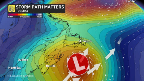
The system will arrive in eastern Newfoundland on Monday night and meet plenty of cold air over the island. Snow that begins late Monday will continue through the day on Tuesday as the low-pressure system swings by the Avalon Peninsula.
While all of Newfoundland will see at least some snow through Tuesday, the heaviest snowfall is expected across the Avalon.
Some communities, including St John's, could wind up with 20-40 cm of accumulation by the time the storm wraps up on Tuesday night. Heavier totals are also possible on the southwestern corner of the island beneath bands of sea-effect snow.

Travel will be hazardous as a result of the snow and wind, especially during the afternoon commute on Tuesday when the blowing snow is expected to be most widespread.
St. John’s has only seen 26.4 cm of snow so far this season, which is less than half of what the city normally picks up by the second week in January. If the current storm stays on its predicted track, we could double that total by Tuesday.
DON'T MISS: Why 2 birders from St. John's drove 2,800 km to see...this
It’s important to keep in mind that snowfall accumulations in eastern Newfoundland will be tied to the storm’s path. A tiny deviation in the storm’s track will nudge the swath of heavy snow right along with it. Stay tuned over the next couple of days as meteorologists closely monitor the progress of this developing storm.
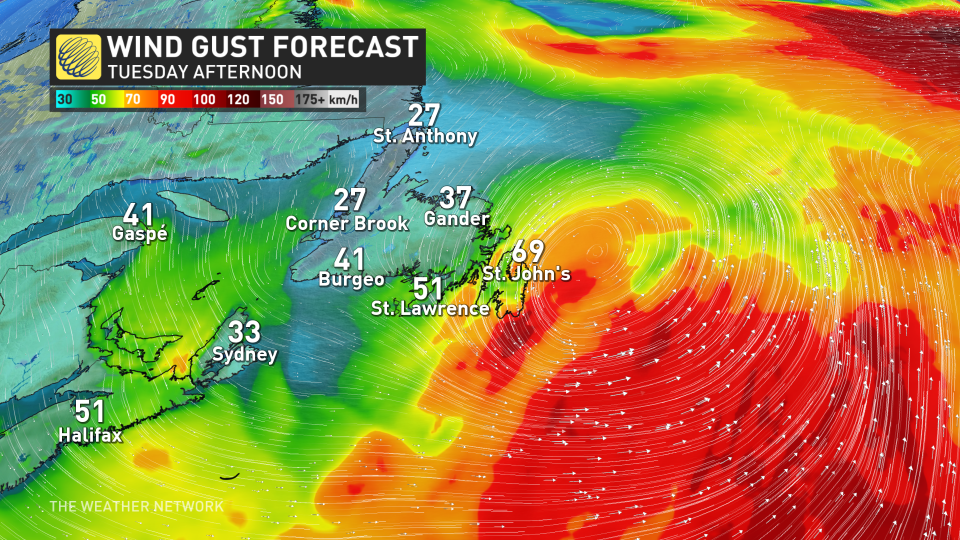
Snow isn’t the only hazard with this system. The centre of this rapidly intensifying low will track fairly close to land, allowing winds to pick up during the height of the storm. We could see gusts of 80-100+ km/h across the Avalon Peninsula through the second half of the day Tuesday.
“Travel will be hazardous as a result [of the strong winds], especially during the afternoon commute on Tuesday when the blowing snow is expected to be most widespread,” Environment and Climate Change Canada (ECCC) warns in their special weather statement for St. John’s.
Temperatures will come in slightly below seasonal behind the storm, with subfreezing temperatures lingering in St. John’s through next weekend.
Thumbnail courtesy of Maggie BB.
Check back for the latest on this snowy forecast across Newfoundland.

