Stay prepared: Canada’s tornado season continues even as summer fades
The dulcet crooning of cicadas and rogue hints of colour appearing in the trees are signs that summer’s long days are beginning to wane. Even as we look forward to the cooler days of fall, we can’t look away from summer’s hazards just yet.
Tornado season reaches its peak across Canada during the middle of the summer, but severe storms can still bring a threat for twisters well into September and beyond for some parts of the country.
DON’T MISS: Tornadoes can happen anywhere—and cities aren't immune
Western University’s Northern Tornadoes Project (NTP) reminded Canadians of the threat for late-summer tornadoes in a recent update.

“Notice how outbreaks in past years show up as big jumps, even into September. In other words, there is still a lot of summer—and tornado season—left!”, the NTP said in its tweet.
One of the NTP’s main objectives is to document the true number of tornadoes that touch down across Canada every year. The vast size of the country means that many twisters likely go undetected by radar and unnoticed as they wind through sparsely populated areas.
Data collected by the NTP since 2017 shows that tornadic activity peaks with the summer months, but the threat for tornadoes continues well into the first half of fall—particularly across Central Canada.
An active year for some, sluggish for others
This year’s national tornado counts have come in a little behind average through the middle of August. We’ve seen 54 confirmed tornadoes from coast to coast so far this year, the vast majority of which touched down in Ontario and Alberta.
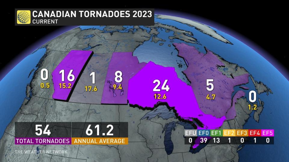
Ontario and Quebec combined are leading the pack so far this season, with 29 tornadoes recorded between the two provinces through the middle of August. Many of those tornadoes have touched down in the National Capital Region, a hard-hit area that witnessed near-weekly severe weather events through much of July and August.
DON’T MISS: Why you can't rule out tornadoes during Ontario's cooler months
Two damaging tornadoes touched down just south of Ottawa in Barrhaven, Ontario, back on July 13. The pair of EF-1 tornadoes each packed estimated winds of 155 km/h, damaging numerous homes in the community.
Farther west, we’ve seen a teeter-totter of activity across the Prairies, courtesy of an ongoing drought that’s led to below-average storm activity for some areas. Saskatchewan has only seen one confirmed tornado in 2023, which is well below the province’s seasonal total of about a dozen.
STAY SAFE: Don’t fall victim to these seven dangerous tornado myths
Alberta has witnessed the lion’s share of the Prairies’ tornadoes so far this year, with 14 twisters documented in the province. Ten of those tornadoes touched down on June 14 alone, becoming Alberta’s second-most active tornado day on record.
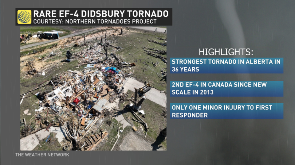
One of Alberta's tornadoes swept through the community of Didsbury on July 1, leaving behind significant damage along a path that measured more than 15 km long. Experts rated this tornado a powerful EF-4 with maximum estimated winds of 275 km/h, becoming Alberta’s strongest tornado since the tragic Edmonton tornado back in 1987.
WATCH: What to do if a tornado warning is issued while driving
What to expect in the weeks ahead
While forecasters can predict general trends weeks in advance—below-seasonal temperatures or above-seasonal precipitation, for instance—tornadoes are tricky to predict more than a few days ahead of time at most.
MUST SEE: Why does your long-range forecast change so often?
History tells us that Ontario and Quebec are the most likely candidates for tornadic thunderstorms as summer gives way to fall.
The jet stream starts to sag south again as the seasons change, pushing the active storm track away from the Prairies and toward southern Ontario and southern Quebec.
This shift puts the Prairies and communities up north on the chillier side of storms as they swirl across Canada, leaving folks in southern portions of Ontario and Quebec exposed to the warm side of disturbances where severe thunderstorms can thrive.
With files from Nathan Howes, a digital journalist for The Weather Network.
Header image courtesy of Braydon Morisseau/The Weather Network.

