Severe risk continues in Ontario, Quebec as storms hit muggy heat

A multi-day heat event continues in Ontario as the first week of July begins to wrap up. The high temperatures and humidity fuelled thunderstorms that prompted tornado warnings for regions of northern Ontario late Wednesday afternoon. As heat warnings remain in place for another day, so does the lingering risk for more thunderstorms on Thursday, with the potential for a swath of severe storms.
JULY OUTLOOK: A turbulent July promises smoke, storms, heat, and drought across Canada
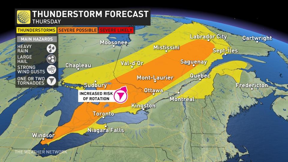
THURSDAY
Areas: Northeastern, eastern, and southern Ontario; Quebec
Time: Afternoon and evening
Weather: The slow-moving cold front that prompted tornado warnings in northeastern Ontario late Wednesday afternoon continues to travel to southern Ontario and Quebec into Thursday, bringing with it a long awaited cooldown.
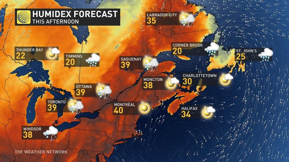
However, those looking for heat relief won’t get it until late Thursday. Expect widespread humidex into the high 30s in southern Ontario to persist throughout the day while the approaching cold front takes its time getting through southern Ontario. By Thursday afternoon it’ll be over the region, triggering another day of active weather.
Tornado 101: What you need to know about staying safe
The highest risk for stronger, severe storms exists along the Lake Huron and Georgian Bay shores, through cottage country, and extending into the northern regions of the Greater Toronto Area (GTA), as well as southern regions of Quebec.
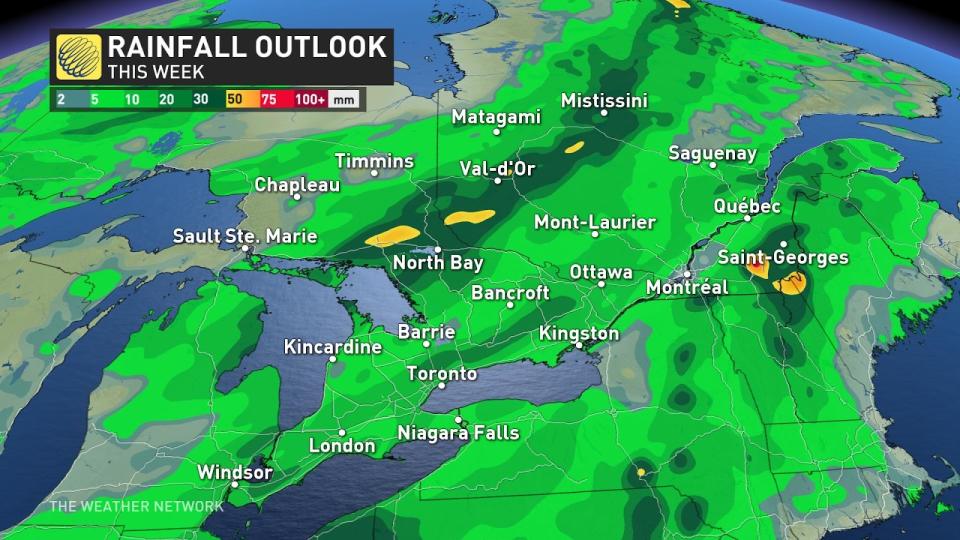
Another region of importance where we could see the potential for rotating storms that could produce tornadoes are parts of cottage country, North Bay, Mattawa, and southwestern Quebec. Due to the slow movement, some regions could pick up over 50 mm of rainfall in a few hours, raising concerns for localised flooding. Other hazards include nickel size hail, strong wind gusts upwards to 90 km/h, and the potential for one or two tornadoes.
DON'T MISS: Solar storm could spark auroras across Canada Friday night
Temperature: Heat warnings continue to span southern Ontario and Quebec, where unseasonably warm temperatures kick off July. The uncomfortably muggy weather continues on Thursday, where humidex values of 40s are possible for Ottawa, Montreal, and much of southern Ontario, too.
Throughout the day today, as the cold front approaches, we will start to see temperatures cooling down for regions along the shores of Lake Huron and Georgian Bay, whereas cities along the 401 corridor, including the GTA and eastern Ontario, which are still locked in a hot, muggy, and, sticky airmass with humidex values into the low-mid 30s.
By Saturday, temperatures will still be hot, but the humidex will be lowered into the high 20s.
Below is a look at some of the impacts so far:
ONStorm pic.twitter.com/T1oM6niGlE
Trevor on Twitter: "#ONStorm pic.twitter.com/T1oM6niGlE / Twitter" Trevor on Twitter: "#ONStorm pic.twitter.com/T1oM6niGlE / Twitter"
— Trevor (@trevorbobyk) Trevor on Twitter: "#ONStorm pic.twitter.com/T1oM6niGlE / Twitter"
Gotta be a funnel cloud over Lake Ontario near down town Toronto right now. Looks big. Anyone confirm? #ONStorm pic.twitter.com/5gOGoDePzj
Gotta be a funnel cloud over Lake Ontario near down town Toronto right now. Looks big. Anyone confirm? ShotByDrew on Twitter: "Gotta be a funnel cloud over Lake Ontario near down town Toronto right now. Looks big. Anyone confirm? #ONStorm pic.twitter.com/5gOGoDePzj / Twitter" ShotByDrew on Twitter: "Gotta be a funnel cloud over Lake Ontario near down town Toronto right now. Looks big. Anyone confirm? #ONStorm pic.twitter.com/5gOGoDePzj / Twitter"
— ShotByDrew (@shotbydrew) ShotByDrew on Twitter: "Gotta be a funnel cloud over Lake Ontario near down town Toronto right now. Looks big. Anyone confirm? #ONStorm pic.twitter.com/5gOGoDePzj / Twitter"
So that was interesting... #OnStorm #TOwx pic.twitter.com/4FwHpWUUuT
So that was interesting… M.J. 🕊 on Twitter: "So that was interesting... #OnStorm #TOwx pic.twitter.com/4FwHpWUUuT / Twitter" M.J. 🕊 on Twitter: "So that was interesting... #OnStorm #TOwx pic.twitter.com/4FwHpWUUuT / Twitter" M.J. 🕊 on Twitter: "So that was interesting... #OnStorm #TOwx pic.twitter.com/4FwHpWUUuT / Twitter"
— M.J. 🕊 (@themjelle) M.J. 🕊 on Twitter: "So that was interesting... #OnStorm #TOwx pic.twitter.com/4FwHpWUUuT / Twitter"
30 min ago at Lake Shore Blvd W. Near Windemere, #MirabellaCondominiums#Toronto #LakeOntario #Weather #StormClouds Stunning.Photo credit @MarcellaRacic @weathernetwork @StormhunterTWN @ONwxchaser pic.twitter.com/gsOCW1lSvK
30 min ago at Lake Shore Blvd W. Near Windemere, ginadibee on Twitter: "30 min ago at Lake Shore Blvd W. Near Windemere, #MirabellaCondominiums#Toronto #LakeOntario #Weather #StormClouds Stunning.Photo credit @MarcellaRacic @weathernetwork @StormhunterTWN @ONwxchaser pic.twitter.com/gsOCW1lSvK / Twitter"ginadibee on Twitter: "30 min ago at Lake Shore Blvd W. Near Windemere, #MirabellaCondominiums#Toronto #LakeOntario #Weather #StormClouds Stunning.Photo credit @MarcellaRacic @weathernetwork @StormhunterTWN @ONwxchaser pic.twitter.com/gsOCW1lSvK / Twitter" ginadibee on Twitter: "30 min ago at Lake Shore Blvd W. Near Windemere, #MirabellaCondominiums#Toronto #LakeOntario #Weather #StormClouds Stunning.Photo credit @MarcellaRacic @weathernetwork @StormhunterTWN @ONwxchaser pic.twitter.com/gsOCW1lSvK / Twitter" ginadibee on Twitter: "30 min ago at Lake Shore Blvd W. Near Windemere, #MirabellaCondominiums#Toronto #LakeOntario #Weather #StormClouds Stunning.Photo credit @MarcellaRacic @weathernetwork @StormhunterTWN @ONwxchaser pic.twitter.com/gsOCW1lSvK / Twitter" ginadibee on Twitter: "30 min ago at Lake Shore Blvd W. Near Windemere, #MirabellaCondominiums#Toronto #LakeOntario #Weather #StormClouds Stunning.Photo credit @MarcellaRacic @weathernetwork @StormhunterTWN @ONwxchaser pic.twitter.com/gsOCW1lSvK / Twitter" Stunning.
Photo credit ginadibee on Twitter: "30 min ago at Lake Shore Blvd W. Near Windemere, #MirabellaCondominiums#Toronto #LakeOntario #Weather #StormClouds Stunning.Photo credit @MarcellaRacic @weathernetwork @StormhunterTWN @ONwxchaser pic.twitter.com/gsOCW1lSvK / Twitter" ginadibee on Twitter: "30 min ago at Lake Shore Blvd W. Near Windemere, #MirabellaCondominiums#Toronto #LakeOntario #Weather #StormClouds Stunning.Photo credit @MarcellaRacic @weathernetwork @StormhunterTWN @ONwxchaser pic.twitter.com/gsOCW1lSvK / Twitter" ginadibee on Twitter: "30 min ago at Lake Shore Blvd W. Near Windemere, #MirabellaCondominiums#Toronto #LakeOntario #Weather #StormClouds Stunning.Photo credit @MarcellaRacic @weathernetwork @StormhunterTWN @ONwxchaser pic.twitter.com/gsOCW1lSvK / Twitter" ginadibee on Twitter: "30 min ago at Lake Shore Blvd W. Near Windemere, #MirabellaCondominiums#Toronto #LakeOntario #Weather #StormClouds Stunning.Photo credit @MarcellaRacic @weathernetwork @StormhunterTWN @ONwxchaser pic.twitter.com/gsOCW1lSvK / Twitter" ginadibee on Twitter: "30 min ago at Lake Shore Blvd W. Near Windemere, #MirabellaCondominiums#Toronto #LakeOntario #Weather #StormClouds Stunning.Photo credit @MarcellaRacic @weathernetwork @StormhunterTWN @ONwxchaser pic.twitter.com/gsOCW1lSvK / Twitter"
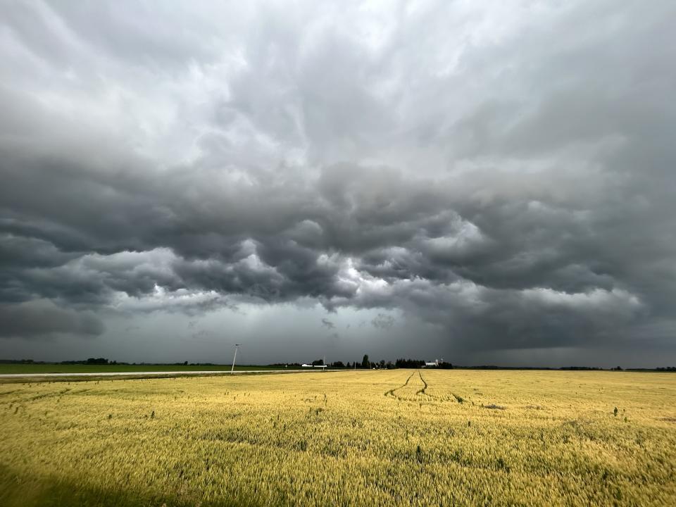
Significant snapped/downed trees, primarily all facing northeast. Largely flattened wheat field in the area as well.Primarily affected 43410 Moncreiff Road; home owner was unwilling to allow pictures.Additional damage at 4334 Moncrieff Road. #onwx #onstorm @NTP_Reports pic.twitter.com/9DPCnD4qcm
Significant snapped/downed trees, primarily all facing northeast. Largely flattened wheat field in the area as well.
Primarily affected 43410 Moncreiff Road; home owner was unwilling to allow pictures.
Additional damage at 4334 Moncrieff Road. Justin M on Twitter: "Significant snapped/downed trees, primarily all facing northeast. Largely flattened wheat field in the area as well.Primarily affected 43410 Moncreiff Road; home owner was unwilling to allow pictures.Additional damage at 4334 Moncrieff Road. #onwx #onstorm @NTP_Reports pic.twitter.com/9DPCnD4qcm / Twitter" Justin M on Twitter: "Significant snapped/downed trees, primarily all facing northeast. Largely flattened wheat field in the area as well.Primarily affected 43410 Moncreiff Road; home owner was unwilling to allow pictures.Additional damage at 4334 Moncrieff Road. #onwx #onstorm @NTP_Reports pic.twitter.com/9DPCnD4qcm / Twitter" Justin M on Twitter: "Significant snapped/downed trees, primarily all facing northeast. Largely flattened wheat field in the area as well.Primarily affected 43410 Moncreiff Road; home owner was unwilling to allow pictures.Additional damage at 4334 Moncrieff Road. #onwx #onstorm @NTP_Reports pic.twitter.com/9DPCnD4qcm / Twitter" Justin M on Twitter: "Significant snapped/downed trees, primarily all facing northeast. Largely flattened wheat field in the area as well.Primarily affected 43410 Moncreiff Road; home owner was unwilling to allow pictures.Additional damage at 4334 Moncrieff Road. #onwx #onstorm @NTP_Reports pic.twitter.com/9DPCnD4qcm / Twitter"
Moving in over Toronto now. @weathernetwork @WxOntario1 @StormHour @Onstormtracker @CP24 pic.twitter.com/b8jooBdAnu
Moving in over Toronto now. A Moment Captured on Twitter: "Moving in over Toronto now. @weathernetwork @WxOntario1 @StormHour @Onstormtracker @CP24 pic.twitter.com/b8jooBdAnu / Twitter" A Moment Captured on Twitter: "Moving in over Toronto now. @weathernetwork @WxOntario1 @StormHour @Onstormtracker @CP24 pic.twitter.com/b8jooBdAnu / Twitter" A Moment Captured on Twitter: "Moving in over Toronto now. @weathernetwork @WxOntario1 @StormHour @Onstormtracker @CP24 pic.twitter.com/b8jooBdAnu / Twitter" A Moment Captured on Twitter: "Moving in over Toronto now. @weathernetwork @WxOntario1 @StormHour @Onstormtracker @CP24 pic.twitter.com/b8jooBdAnu / Twitter" A Moment Captured on Twitter: "Moving in over Toronto now. @weathernetwork @WxOntario1 @StormHour @Onstormtracker @CP24 pic.twitter.com/b8jooBdAnu / Twitter" A Moment Captured on Twitter: "Moving in over Toronto now. @weathernetwork @WxOntario1 @StormHour @Onstormtracker @CP24 pic.twitter.com/b8jooBdAnu / Twitter"
— A Moment Captured (@JeffTaylorTPS) A Moment Captured on Twitter: "Moving in over Toronto now. @weathernetwork @WxOntario1 @StormHour @Onstormtracker @CP24 pic.twitter.com/b8jooBdAnu / Twitter"
Just east of Alliston on the 89 and I'm watching a big lowering to my north. @weathernetwork #ONStorm pic.twitter.com/2qj2iFPe04
Just east of Alliston on the 89 and I’m watching a big lowering to my north. Mark Robinson on Twitter: "Just east of Alliston on the 89 and I'm watching a big lowering to my north. @weathernetwork #ONStorm pic.twitter.com/2qj2iFPe04 / Twitter" Mark Robinson on Twitter: "Just east of Alliston on the 89 and I'm watching a big lowering to my north. @weathernetwork #ONStorm pic.twitter.com/2qj2iFPe04 / Twitter" Mark Robinson on Twitter: "Just east of Alliston on the 89 and I'm watching a big lowering to my north. @weathernetwork #ONStorm pic.twitter.com/2qj2iFPe04 / Twitter"
— Mark Robinson (@StormhunterTWN) Mark Robinson on Twitter: "Just east of Alliston on the 89 and I'm watching a big lowering to my north. @weathernetwork #ONStorm pic.twitter.com/2qj2iFPe04 / Twitter"
Beast mode activated, multi tiered gorgeous shelf. Just outside Alisa, Craig earlier with the line that came off Huron. @IWeatherON @Onstormtracker @weathernetwork @HuronSupercells @LakeErieNorth @GirlsWhoChase #ONStorm #onwx pic.twitter.com/y0FJTFo9hf
Beast mode activated, multi tiered gorgeous shelf. Just outside Alisa, Craig earlier with the line that came off Huron. Tempest Hunter 🇺🇦☮ on Twitter: "Beast mode activated, multi tiered gorgeous shelf. Just outside Alisa, Craig earlier with the line that came off Huron. @IWeatherON @Onstormtracker @weathernetwork @HuronSupercells @LakeErieNorth @GirlsWhoChase #ONStorm #onwx pic.twitter.com/y0FJTFo9hf / Twitter" Tempest Hunter 🇺🇦☮ on Twitter: "Beast mode activated, multi tiered gorgeous shelf. Just outside Alisa, Craig earlier with the line that came off Huron. @IWeatherON @Onstormtracker @weathernetwork @HuronSupercells @LakeErieNorth @GirlsWhoChase #ONStorm #onwx pic.twitter.com/y0FJTFo9hf / Twitter" Tempest Hunter 🇺🇦☮ on Twitter: "Beast mode activated, multi tiered gorgeous shelf. Just outside Alisa, Craig earlier with the line that came off Huron. @IWeatherON @Onstormtracker @weathernetwork @HuronSupercells @LakeErieNorth @GirlsWhoChase #ONStorm #onwx pic.twitter.com/y0FJTFo9hf / Twitter" Tempest Hunter 🇺🇦☮ on Twitter: "Beast mode activated, multi tiered gorgeous shelf. Just outside Alisa, Craig earlier with the line that came off Huron. @IWeatherON @Onstormtracker @weathernetwork @HuronSupercells @LakeErieNorth @GirlsWhoChase #ONStorm #onwx pic.twitter.com/y0FJTFo9hf / Twitter" Tempest Hunter 🇺🇦☮ on Twitter: "Beast mode activated, multi tiered gorgeous shelf. Just outside Alisa, Craig earlier with the line that came off Huron. @IWeatherON @Onstormtracker @weathernetwork @HuronSupercells @LakeErieNorth @GirlsWhoChase #ONStorm #onwx pic.twitter.com/y0FJTFo9hf / Twitter" Tempest Hunter 🇺🇦☮ on Twitter: "Beast mode activated, multi tiered gorgeous shelf. Just outside Alisa, Craig earlier with the line that came off Huron. @IWeatherON @Onstormtracker @weathernetwork @HuronSupercells @LakeErieNorth @GirlsWhoChase #ONStorm #onwx pic.twitter.com/y0FJTFo9hf / Twitter" Tempest Hunter 🇺🇦☮ on Twitter: "Beast mode activated, multi tiered gorgeous shelf. Just outside Alisa, Craig earlier with the line that came off Huron. @IWeatherON @Onstormtracker @weathernetwork @HuronSupercells @LakeErieNorth @GirlsWhoChase #ONStorm #onwx pic.twitter.com/y0FJTFo9hf / Twitter" Tempest Hunter 🇺🇦☮ on Twitter: "Beast mode activated, multi tiered gorgeous shelf. Just outside Alisa, Craig earlier with the line that came off Huron. @IWeatherON @Onstormtracker @weathernetwork @HuronSupercells @LakeErieNorth @GirlsWhoChase #ONStorm #onwx pic.twitter.com/y0FJTFo9hf / Twitter" Tempest Hunter 🇺🇦☮ on Twitter: "Beast mode activated, multi tiered gorgeous shelf. Just outside Alisa, Craig earlier with the line that came off Huron. @IWeatherON @Onstormtracker @weathernetwork @HuronSupercells @LakeErieNorth @GirlsWhoChase #ONStorm #onwx pic.twitter.com/y0FJTFo9hf / Twitter"
— Tempest Hunter 🇺🇦☮ (@tempesthunterph) Tempest Hunter 🇺🇦☮ on Twitter: "Beast mode activated, multi tiered gorgeous shelf. Just outside Alisa, Craig earlier with the line that came off Huron. @IWeatherON @Onstormtracker @weathernetwork @HuronSupercells @LakeErieNorth @GirlsWhoChase #ONStorm #onwx pic.twitter.com/y0FJTFo9hf / Twitter"
Into the core near North Perth! @weathernetwork #ONStorm pic.twitter.com/j13E3Jz8SH
Into the core near North Perth! Mark Robinson on Twitter: "Into the core near North Perth! @weathernetwork #ONStorm pic.twitter.com/j13E3Jz8SH / Twitter" Mark Robinson on Twitter: "Into the core near North Perth! @weathernetwork #ONStorm pic.twitter.com/j13E3Jz8SH / Twitter" Mark Robinson on Twitter: "Into the core near North Perth! @weathernetwork #ONStorm pic.twitter.com/j13E3Jz8SH / Twitter"
— Mark Robinson (@StormhunterTWN) Mark Robinson on Twitter: "Into the core near North Perth! @weathernetwork #ONStorm pic.twitter.com/j13E3Jz8SH / Twitter"
Here we go. Near Brussels now, NW of Kitchener. @weathernetwork #ONStorm pic.twitter.com/rUCVhnIge4
Here we go. Near Brussels now, NW of Kitchener. Mark Robinson on Twitter: "Here we go. Near Brussels now, NW of Kitchener. @weathernetwork #ONStorm pic.twitter.com/rUCVhnIge4 / Twitter" Mark Robinson on Twitter: "Here we go. Near Brussels now, NW of Kitchener. @weathernetwork #ONStorm pic.twitter.com/rUCVhnIge4 / Twitter" Mark Robinson on Twitter: "Here we go. Near Brussels now, NW of Kitchener. @weathernetwork #ONStorm pic.twitter.com/rUCVhnIge4 / Twitter"
— Mark Robinson (@StormhunterTWN) Mark Robinson on Twitter: "Here we go. Near Brussels now, NW of Kitchener. @weathernetwork #ONStorm pic.twitter.com/rUCVhnIge4 / Twitter"
Brussels, Ontario. July 6, 2023 (Credit: Mark Robinson/The Weather Network)
Good winds in the core, but not damaging as of yet. @weathernetwork #ONStorm pic.twitter.com/RgEVfWWx9Y
Good winds in the core, but not damaging as of yet. Mark Robinson on Twitter: "Good winds in the core, but not damaging as of yet. @weathernetwork #ONStorm pic.twitter.com/RgEVfWWx9Y / Twitter" Mark Robinson on Twitter: "Good winds in the core, but not damaging as of yet. @weathernetwork #ONStorm pic.twitter.com/RgEVfWWx9Y / Twitter" Mark Robinson on Twitter: "Good winds in the core, but not damaging as of yet. @weathernetwork #ONStorm pic.twitter.com/RgEVfWWx9Y / Twitter"
— Mark Robinson (@StormhunterTWN) Mark Robinson on Twitter: "Good winds in the core, but not damaging as of yet. @weathernetwork #ONStorm pic.twitter.com/RgEVfWWx9Y / Twitter"
Follow The Weather Network on Twitter for on-the-ground updates.
Stay tuned to The Weather Network across all platforms for more forecast updates for Ontario and Quebec.

