New storm could bring more peril to California rivers already hit by deadly flooding
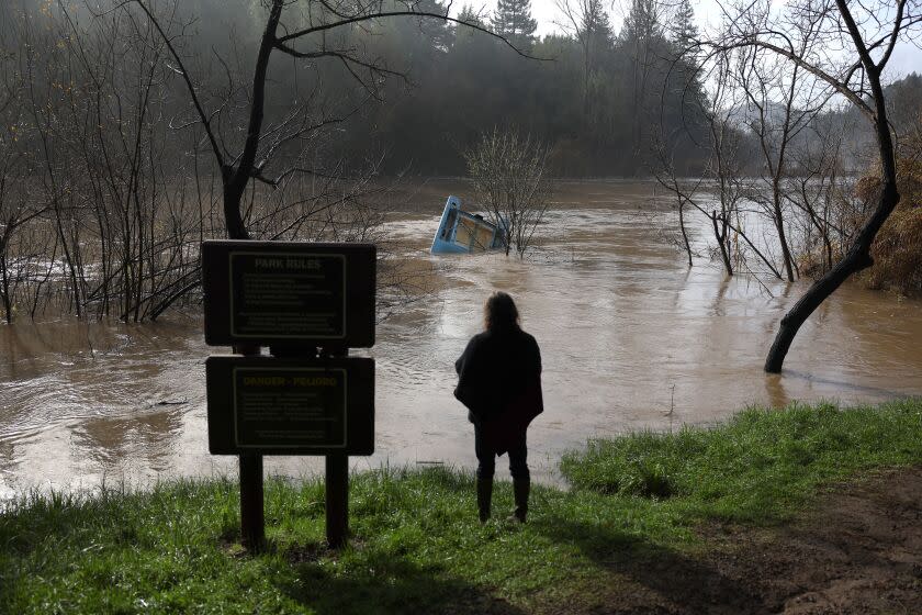
A powerful storm barreling toward California from the tropical Pacific threatens to trigger widespread river flooding throughout the state as warm rain melts a record accumulation of snowpack and sends runoff surging down mountains and into streams and reservoirs.
Although state officials insist they are prepared to manage runoff from what is now the 10th atmospheric river of a deadly rainy season, at least one expert described the combination of warm rain, epic snowpack and moist soils as "bad news."
“We’re expecting rain in the areas where there was snow, and the rain is warm, and it will melt the snow that is already there,” said Alistair Hayden, a former division chief at the California Governor's Office of Emergency Services. “So what’s going to run into the rivers is not just the rain that’s falling from the sky — it’s going to unlock some of the precipitation that fell as snow, so it could be big.”
Already, the National Weather Service is warning residents that a number of rivers could surge beyond their flood stage, inundating nearby roads and properties. Likewise, some reservoir managers have already begun releasing water in anticipation of heavy inflows through the weekend.
At Oroville Dam — which suffered a near catastrophic failure amid a series of atmospheric rivers in 2017 — state operators said they could begin releasing water down the dam's re-built main spillway as early as Friday.
Although Southern California can expect to see some fallout from the warm "Pineapple Express" the brunt of the storm system is expected to strike Northern and Central California the hardest. Areas below 4,000 feet elevation, where snowpack has been unusually deep this year, are anticipated to see the heaviest runoff.

According to the weather service, rivers that could see flooding include the Russian River at Hopland; the Salinas River at Bradley and Spreckels; the Merced River at Stevinson; the Tuolumne River at Modesto; the Cosumnes River at Michigan Bar; the Mokelumne River at Benson's Ferry; and Bear Creek at McKee Road.
Many of those rivers flooded in January, when nine back-to-back atmospheric rivers hammered the state, causing nearly a dozen levee breaches along the Cosumnes River near Sacramento and contributing to at least 22 deaths, including people killed by falling trees and surging waters.
During those storms, the Salinas River at Spreckels reached one of its highest flood levels on record, while the Cosumnes River posted its second-highest river flow. Bear Creek rose to 26.18 feet, exceeding a prior record set in 2006.
Dan Harty, a meteorologist with the National Weather Service in Hanford, said it's possible that some places, including locations along the Merced River, could see flooding of similar magnitude during the incoming storm.
"It's kind of a low-lying area that is prone to flooding with high rain rates, so that's definitely a concern again," Harty said. The Hanford office has issued a flood watch for almost its entire coverage area, which runs from the Grapevine, in Kern County, north to Yosemite Valley.
Reservoir operators are eyeing the storm closely.
"The good thing is it looks like a lot of our reservoirs still have adequate space to take on a lot of water in the near term," said Tyler Stalker, a spokesman for the U.S. Army Corps of Engineers in Sacramento. "Obviously with the big snowpack, though, there's a lot of potential water to still flow in there."
Stalker said the Army Corps is already making some releases from its reservoirs to make room for incoming flows, including the Schafer Dam on the Kern River, the Pine Flat Dam on the Kings River and the New Hogan Dam on the Calaveras River. The agency has also made releases from Lake Mendocino, according to Nick Malasavage, chief of operations and readiness with the San Francisco division.
"Our reservoirs are going to do what they're designed to do — which is to capture the rain that falls from the sky, and the snow that melts because of that rain that's falling from the sky," Malasavage said. But while January's storms helped fill reservoirs severely depleted by the state's driest three years on record, circumstances are now a bit more precarious, he said.
"Where we had not a whole lot of concern in January, there's a little bit more concern now because we have to be more precise about our decision-making," he said. Along the Russian River, for example, only about 20% of the watershed is behind Army Corps dams and the rest is unregulated, he said.
"There's a decent amount of flood risk that is mitigated — or is kept from getting too, too bad — because of the existence of the lakes, but there is always that threat to us and our communities when there's just an aggressive storm," he said.
While individual atmospheric river events are not always cause for concern, they can quickly turn threatening when they interact with other factors such as snowpack and damp soils, according to Hayden, the former emergency services official, who is now a professor of practice in public and ecosystem health at Cornell University.
"What perhaps was slightly unusual about the January event was it was just back-to-back-to-back, and now this forecast March event is yet another one while the soil is still, in many places, saturated, so that can exacerbate flooding," Hayden said.
In fact, the National Weather Service predicts that nearly two dozen additional river locations across the state may surge above their "monitor stage" — meaning they could potentially overflow their banks and cause minor flooding in low-lying areas. That includes multiple locations along the Sacramento and the San Joaquin rivers.
Officials in Fresno and Madera counties have issued evacuation warnings for residents in their areas, warning of potentially serious flooding from the incoming storm.
"The threat level is elevated enough that an Evacuation Warning is necessary and prudent due to the incoming weather event," the Madera County Sheriff's Office said in its alert.
Fresno County Sheriff's Office spokesman Tony Botti said officials there are particularly concerned about flooding around Pine Flat, as well as Millerton Lake, which feeds into the San Joaquin River and flows west toward Mendota, Tranquility and other communities. He said the department is stationing rescue personnel and equipment — including boats and snow plows — at multiple locations across the county.
The atmospheric river, which is gathering warm subtropical moisture coming up from Hawaii, will fall atop some of the deepest snowpack California has ever recorded. The Department of Water Resource's third snow survey of the season, conducted Friday, found that statewide snowpack was 190% of normal — hovering just below the record set in the winter of 1982-83.
But while recent storms have been colder, the warmth of the incoming system means there will be "more precipitation as rainfall instead of snowfall," said Jeremy Hill, manager of the Hydrology and Flood Operations Branch at DWR.
"We are expecting more runoff in the rivers and streams, and several locations to reach levels that require some monitoring of the conditions, and potentially some localized impacts as well," he said
In 2017, heavy rainfall and erosion from floods damaged spillways at Oroville Dam, one of California's largest reservoirs, and sent more than 100,000 people fleeing from a potential surge of overflowing water. Hill said there is no danger of such an event happening in the incoming storm as "Oroville has space to absorb these inflows that are forecast right now."
"They do have space in the reservoir, thankfully, as does Shasta even more so," he said, referring to California's other largest reservoir. Lake Oroville and Lake Shasta are currently at 75% and 61% capacity, respectively, according to state data.
"There's a lot of preparations in place," Hill said. "The reservoir operators are of course aware of the storms, so they are making releases as needed, and are of course going to track the conditions of the storm throughout the event as well."
Hayden said he hoped January's floods helped officials identify potential areas of weakness ahead of the upcoming storm. But he also said climate change is making many weather patterns harder to predict.
"Earlier events are a run for future events, but each one will play out differently," he said. "So I don't know how well we know — even if an area flooded last time — how it will this time."
He noted that while atmospheric rivers can cause some damage, they also account for a large amount of the state's moisture in a given year. This year's wet winter has already helped ease California's drought conditions considerably, with more than half of the state no longer under drought conditions, according to federal government estimates.
However, it's still important for people to take precautions. Multiple officials said residents should heed all evacuation orders and never drive through floodwaters, even if they appear shallow.
Officials are also concerned that additional storms could create more problems in the wake of this one. Though clouds are expected to clear by the weekend, another atmospheric river system is forecast to arrive as early as Monday night.
This story originally appeared in Los Angeles Times.

