After the storm: Dangerous stretch of subzero AccuWeather RealFeel® Temperatures to grip northeastern US
A polar plunge of brutally cold air is following this weekend's blockbuster winter storm, which can threaten lives and complicate travel and cleanup efforts.
Even the areas that escape snow or ice this weekend will be shivering in the Midwest and Northeast. Between lingering effects of the storm and the cold, there can be further disruptions to daily routines during this Dr. Martin Luther King, Jr. holiday weekend. Schools not already closed on Monday may have delays or cancellations.
The brutal cold that dropped temperatures down to around 40 below zero in International Falls, Minnesota, will continue to plunge on the backside of the storm from the Plains to the East through Sunday.
The snow and ice that the storm will leave will be enough of a chore to clear, but those outside shoveling or children playing in the snow will have to bundle up to avoid hypothermia.

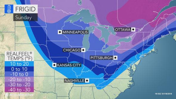
"Many places in the Great Lakes and into the Ohio Valley will not get out of the teens for a high temperature on Sunday," according to AccuWeather Senior Meteorologist Paul Walker. "The last time that occurred in Chicago, Detroit, Indianapolis and Cincinnati was last winter."
Temperatures will be on a free fall across most of New England and the mid-Atlantic on Sunday with highs being recorded in the morning or midday hours.
Residents along the Interstate 95 corridor, including in New York City, Philadelphia and Washington, D.C., could see temperatures plummet from near or above 50 F in the morning to freezing by the evening.
The swiftly plummeting temperatures will cause any wet or slushy areas on roads and sidewalks to freeze and turn icy in the mid-Atlantic and southern New England. Slush or wet snow not cleared will turn into a solid sheet of ice, making it extremely difficult to shovel.
Along the I-95 corridor in the mid-Atlantic, there may be enough time for most roads to dry out before temperatures drop below freezing. There can still be puddles, however, around Sunday evening and night that can turn icy.
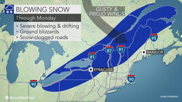
Gusty winds ushering in the bitter cold can worsen the situation by creating dangerously lower AccuWeather RealFeel® Temperatures. In areas hit by the burying snowstorm, the winds will allow ground blizzards to persist even after snow has stopped falling.
In open areas from northeastern Ohio and northern Pennsylvania to Maine, snow drifts can reach 8-10 feet. The severe blowing and drifting can keep travel extremely difficult and delay when crews can reach more remote areas.
"Roads cleared by accumulating snow during the storm may become blocked again due to extensive drifting snow in the storm's wake through Monday," according to AccuWeather Senior Meteorologist Alex Sosnowski.
That can create a life-threatening situation for those who become stranded or lose power and have to wait for help.
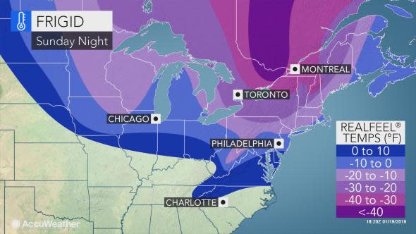
RealFeel® Temperatures may stay below zero F in many communities in the Midwest and Northeast for more than 30-consecutive hours when the brutal cold invades.
On Sunday night, RealFeels can plummet to near or under 20 below zero F across a large swath of the central Great Lakes and Northeast. This includes in Detroit, Buffalo, New York City and Boston.
Proper attire should be worn when heading out to view the total lunar eclipse on Sunday night, where clouds cooperate.
In the Northeast, RealFeels may barely recover even during the daylight hours on Monday and despite sunshine returning.
Download the free AccuWeather app to find out how dangerously cold it is expected to get in your community.
As the frigid air pours over the Great Lakes, bands of lake-effect snow and squalls can stream downwind of the lakes and lead to more travel hazards.
Those who become stranded on snow-clogged roads are reminded to keep tailpipes clear to avoid deadly carbon monoxide poisoning.
"Residents who lose power during or after the storm when the winds increase and must rely on generators for heat should remember to never operate them indoors," according to Walker.
"Be sure that pets and livestock have proper shelter and attach heat cables to water pipes to ensure they do not freeze," he added. Turning faucets on to a slow drip will also aid in preventing pipes from freezing.
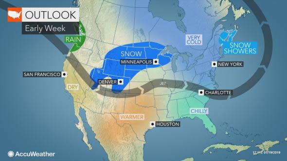
Biting winds are expected to ease by Tuesday, but the cold will hold across the upper Great Lakes and most of the Northeast.
Temperatures can rebound across the Ohio Valley this day ahead of a new storm set to return more snow to the Midwest on Tuesday and then parts of the Northeast Wednesday and Thursday.
AccuWeather meteorologists will also be monitoring the risk for ice in some communities, especially since roads and sidewalks will hold in subfreezing cold much longer than the air temperature after this weekend's Arctic outbreak.