When will this storm end? Here’s what is next for Northern California wind, rain and snow
Northern California’s wet weather is forecast to end Wednesday, you just have to get through the toughest part of the storm.
Tuesday will bring the heaviest rain, wind and snow to the region, according to the National Weather Service. A flood watch, flood advisory and high wind warning were issued for areas across Northern California.
Winds are forecast to gust between 50 mph to 60 in the valley, with winds over the mountains reaching up to 70 mph. The heaviest valley rain will end early Tuesday afternoon, but isolated thunderstorms will likely follow.
“Damaging winds will blow down trees and power lines,” the weather service wrote in a Tuesday statement.
Overly saturated soil doesn’t help. The weather service urges people to stay indoors and far from trees, branches and windows. If possible, huddle in the lower levels of your home during the high winds.
Travel will be difficult, especially for larger vehicles.
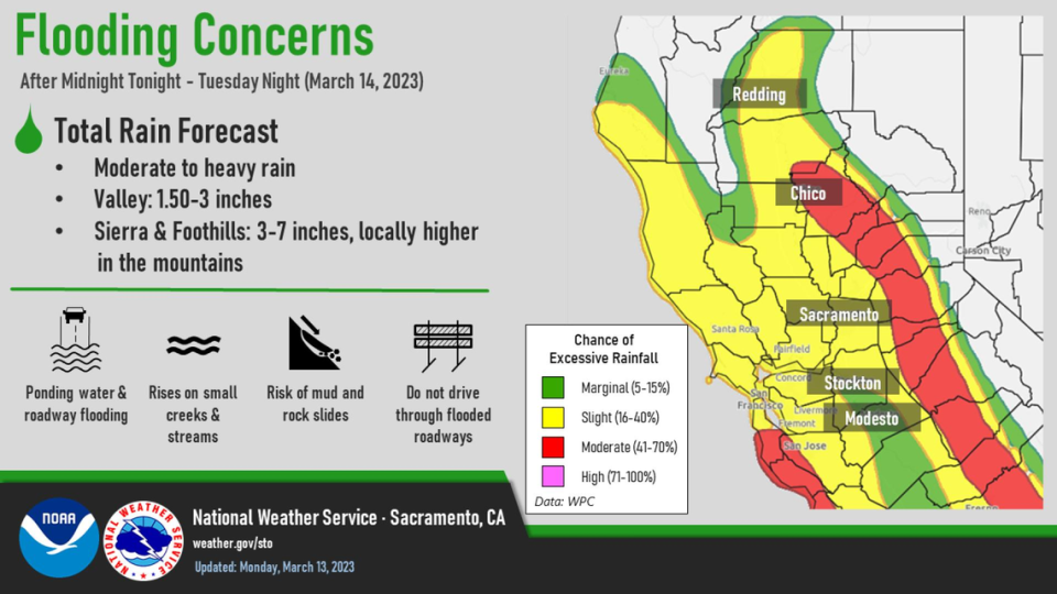
How much more rain and snow will fall in Northern California?
Up to an inch of rain will fall in Sacramento between Tuesday and Wednesday, said meteorologist Idamis Del Valle-Shoemaker with the National Weather Service.
The foothills could receive 1 to 3 more inches of rain before the latest storm ends.
Heavy mountain snow will fall Tuesday between elevations of 6,500 and 8,500 feet. When mixed with rain, roadways could flood, the weather service wrote in a social media post.
Showery weather will continue across interior #NorCal today. Another strong storm will move into the region tonight and Tuesday bringing increasing wind and precipitation with renewed flooding concerns. #CAwx pic.twitter.com/5zJKehbJ64
— NWS Sacramento (@NWSSacramento) March 13, 2023
“For the most part, things will be tapering off by Wednesday morning,” said meteorologist Idamis Del Valle-Shoemaker with the National Weather Service.
Both the rain and snow will end Wednesday. Meteorologists forecast dry, cloudy conditions Friday until the next set of weak rainstorms arrives.
Some rain is forecast to fall between late Friday night and Saturday, then another round of light sprinkles could fall Sunday into early next week.
Light drizzles are expected in the region on and off next week.
Northern California river levels and flood risk
Moderate to heavy rain could flood roadways and streams and push river levels higher.
Flood risk is greatest in the lower-elevation foothills, according to the weather service map.
Five sandbag locations are open throughout Sacramento County, but you have to use your own shovel. Here are the details:
Branch Center - 3847 Branch Center Road
Orangevale Community Center - 6826 Hazel Ave.
Westside Park - 6555 West 2nd St.
Wilton Fire Station - 10661 Alta Mesa Road
Point Pleasant United Methodist Church - 3329 Point Pleasant Road
River levels in the region are also being monitored, and the Cosumnes River could see come flooding.
As of Tuesday morning, the south Sacramento County river at McConnell was several feet above its monitor stage at 38.9 feet. Its flood stage is 42 feet.
By Wednesday afternoon, the river could rise to 42.2 feet.
The river at Michigan Bar was also above its monitor stage on both Monday and Tuesday and is forecast to rise slightly above its flood stage to 12.7 feet by Tuesday night.
The monitor stage for the Sacramento River at I Street is 27.5 feet and the flood stage is 33.5 feet. As of Tuesday morning, the river is above its monitor stage and is not projected to rise much more.
The monitor stage for the American River at the H Street Bridge is 39 feet and the flood stage is 42. As of Tuesday morning, the river entered its monitor stage and is not projected to rise much more.
What do you want to know about life in Sacramento? Ask our service journalism team your top-of-mind questions in the module below or email servicejournalists@sacbee.com.

