Power coming back: Region rebounds from rough weather

WORCESTER — Power has returned to many homes in Worcester County that were in the dark for hours after a powerful storm brought high winds and heavy rain to New England.
By Tuesday morning, National Grid was reporting about 4,000 customer outages in the region, down from 25,000 on Monday morning.
The timeline for full power restoration wasn't clear, but it would be a multi-day process, John Lamontagne, a spokesperson with National Grid, said Monday.
Power play Outage map, Massachusetts Emergency Management Agency
The company was prioritizing 911 calls because Monday's storm was "significant," responding to downed power lines and ensuring power was restored to critical facilities such as hospitals.
Some areas may see power restored faster than others where the damage is more significant, but the company would have a clearer idea once it was able to assess it later in the day Monday, Lamontagne said.

While power failures were scattered across the county Monday morning, the southern part of the county was seeing the greatest impact. At 4:30 p.m., the majority of National Grid customers in Millville and Mendon remained without power.
Statewide, there were nearly 135,000 customers without power early Tuesday.
Despite the heavy rainfall and high wind gusts, Worcester broke a record-high temperature from 1928 Monday.
Torry Dooley, a meteorologist with the National Weather Service in Boston, said the temperature near the airport reached 60 degrees Monday afternoon, bringing it ahead of the 57-degree record set on Dec. 18 95 years ago.
Dooley also said a flood warning had been issued in Fitchburg for the North Nashua River.
Flood watches are out for Worcester County, but no other warnings, aside from Fitchburg, had been issued by Monday afternoon.
He said that people should follow the National Weather Service’s saying, “Turn around, don’t drown.”
If people come across a flooded area, they should turn around and find an alternative path because they won’t be able to tell what the depth of the water is or the condition of the road underneath.
Tree goes into house, but it could have been worse
While sitting in his living room in Northborough, John Mauro, a retired fire chief and emergency manager, who also describes himself as a "weather geek," said he heard around 11:15 a.m. a familiar noise — the sound of a tree snapping.
Looking outside his window, Mauro feared he'd see a tree come crashing into his house and deck. But he got lucky, he said, when the tree fell just beside his house and deck, narrowly missing a shed nearby and instead only causing a relatively small amount of damage to a nearby fence and scratching the side of the deck.
Northborough 2.47” rain total so far. Many reports of street flooding and trees and limbs and power lines down in this area. The squall line that came through about 1115 took out a tree in my yard. I was one of the lucky ones. @WX1BOX pic.twitter.com/k87IJjsGnb
— John Mauro (@JDMauroJr) December 18, 2023
"It couldn't have landed any more perfectly," Mauro said. "Compared to some of the other people who have not been so lucky today."
Mauro said his power flickered some throughout the morning and afternoon, but that he hadn't lost power.
Earlier in the morning, he had driven through Southborough, where he saw minor street flooding, small branches and tree limbs in the roads and storm drains clogged with leaves.
Flights canceled, roads flooded
Flights at Logan Airport, where a wind gust of 68 mph was recorded, were grounded and more than 100 were canceled.
In Holden, crews were busy cleaning fallen branches from roadways throughout town. One branch struck a bus on Route 31. There were no injuries. In Millbury, flooding limited Route 146 north to one lane of travel.
The New England Botanic Garden at Tower Hill canceled Monday's Night Lights due to the high winds.
Early Monday afternoon, a section of Route 9 in Shrewsbury, between South and Grafton streets, was temporarily closed when flooding made the highway impassable.
There was also roadway flooding in Charlton on I-90 westbound at Exit 81, where the Massachusetts Department of Transportation warned drivers to expect delays.
What does the extended forecast look like?
The high winds, which reached 48 mph in Worcester and 51 mph in Fitchburg Monday morning, were expected to continue through the afternoon, slowing down to 20 to 40 mph between 2 and 5 p.m., before slowly diminishing in the evening.
The rain was also expected to continue falling through the afternoon, although it was expected to come to an end before the wind diminishes, Dooley said.
By late Monday morning, the county had received about 1 to 2 inches of rain, while Worcester airport recorded 1.26 inches. The final amount of rain won’t be known until Tuesday.
That came on top of 2.73 inches of rain parts of the city received last week.
Prior to this latest storm, Dooley said, the city had received about 60.20 inches of rain, which is more than a foot above the average of 46.44.
The highest recorded annual rainfall total for Worcester is 68.96 inches in 1972.
Extra utility crews at work
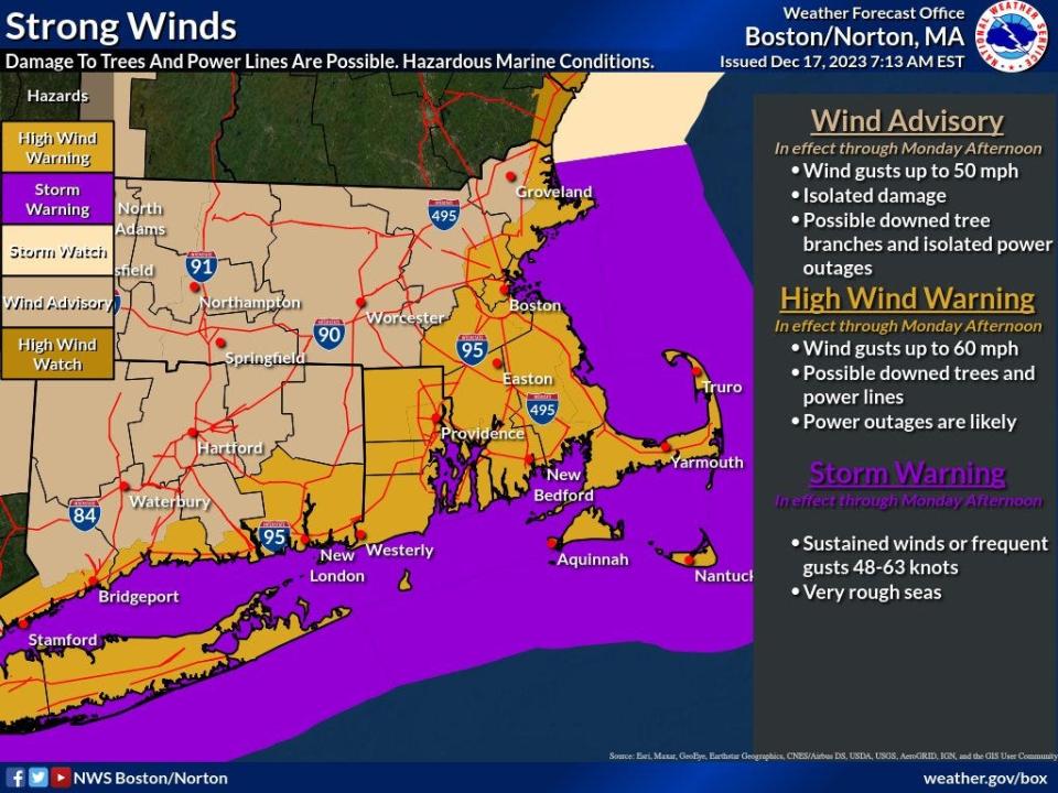
A strong storm system will bring heavy rain and high winds to southern New England early Monday. Gusty winds as high as 65mph could down trees and cause power outages. Heavy rain of 3-4” could cause poor drainage and river flooding. #MAWX #CTWX #RIWX pic.twitter.com/P6Ly4ZQhLg
— NWS Boston (@NWSBoston) December 17, 2023
National Grid said Sunday it would have extra crews in the field should power outages occur.
“National Grid is closely monitoring the weather forecasts, and we have crews and personnel in place across Massachusetts ready to respond to any impacts this storm may bring,” said Tim Moore, vice president of electric operations in New England.
A weather front that caused flooding in Florida sent the wind and rain our way. It’s a mix of a low-pressure system with some “tropical ingredients,” said Kyle Pederson, a meteorologist at the National Weather Service.
After the front moves out of the Worcester area Monday, we could see lingering rain and a few snow flurries, with temperatures reaching the mid-40s Tuesday. Wednesday through Friday looks to be mostly sunny with high temperatures approaching 40.
This article originally appeared on Telegram & Gazette: Storm front coming to Massachusetts: High winds, rains expected

