Storm Isha: Tornado warning as 90mph winds batter Britain
A tornado could hit western parts of the UK amid Storm Isha, the Met Office has warned as 90mph gusts lashed the British Isles.
A “tornado watch” zone was issued for parts of northern England, Scotland and Northern Ireland, meaning a “strong tornado” is possible in those regions.
Met Office forecaster Marco Petagna said: “There is a potential that we could see the odd isolated tornado largely tied in with the squally cold front mainly in western parts of the UK on Sunday evening. They can cause some significant damage but often on a very localised scale, they often don’t tend to last very long.”
It comes as Britain is blanketed by “unusual” danger-to-life wind warnings, with people warned not to travel amid 90mph gusts. The Met Office even warned the public not to sleep near windows tonight.
Rail, sea and air passengers are set to face disruption, with closures, cancellations and delays expected across many services.
Follow the latest updates below.
05:22 AM GMT
This blog is now closed.
Coverage will continue on Monday. Click here
02:54 AM GMT
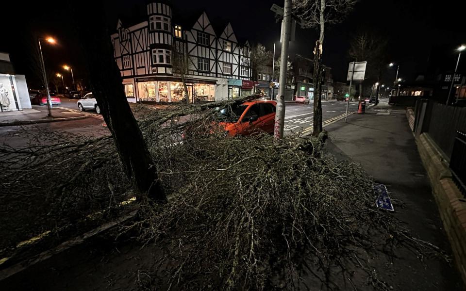
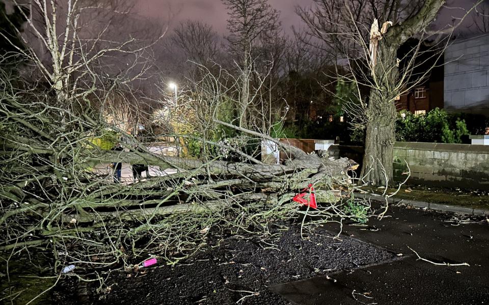
Beware of falling trees
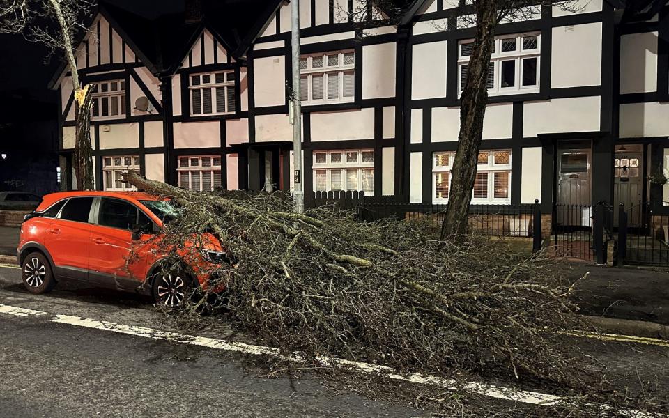
We’re seeing more photos of the destruction caused by falling trees.
It was lucky no one was hurt when this big branch fell on a car in Lisburn Road, in Belfast:

Nearby Notting Hill Road was blocked:
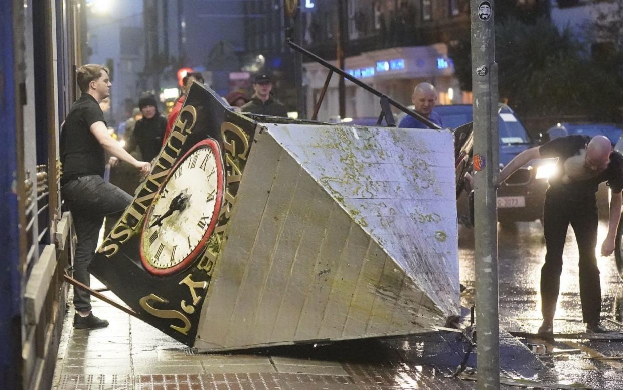
Earlier, emergency crews worked to clear scaffolding that fell from a building in central Belfast:
02:32 AM GMT
Red warning now in place
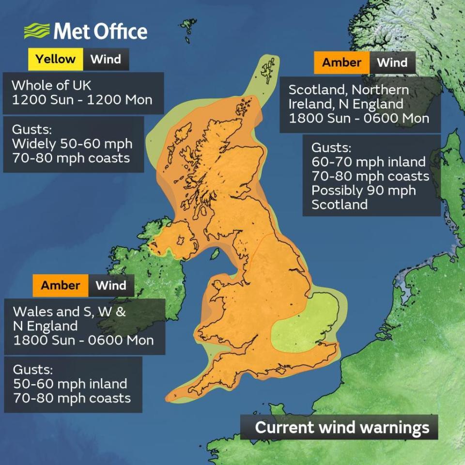
A red warning for wind in northern Scotland came into effect at 1am and will remain in place until at least 5am.
The warning covers Thurso and Wick to the north, Fraserburgh and Peterhead to the east and goes as far west as Cromarty and Nairn.
People are warned to expect flying debris resulting in danger to life.
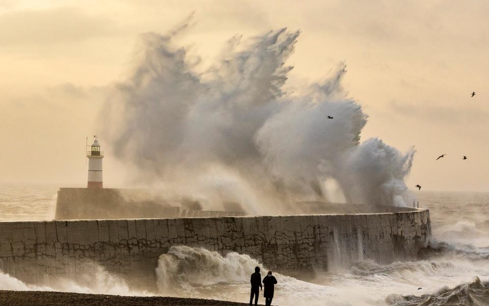
Large waves are expected and could cause debris, seaweed and other beach material to be thrown onto coastal roads, sea fronts and homes.
Roads, bridges and railway lines may be closed, with delays and cancellations to bus, train, ferry services and flights.
Expect power outages and for mobile phone services to be disrupted.
⚠️⚠️🔴 Red weather warning issued 🔴⚠️⚠️
Wind across northeast Scotland
Monday 0100 – 0500
Latest info 👉 https://t.co/QwDLMfRBfs
Stay #WeatherAware ⚠️ pic.twitter.com/RqhTGAj6aG— Met Office (@metoffice) January 21, 2024
11:01 PM GMT
Tree branch falls on car in Belfast
A tree branch fell on a car on Lisburn Road in Belfast during Storm Isha. A Status Red wind warning has been issued for counties Donegal, Galway and Mayo as authorities warn people to take care ahead of Storm Isha’s arrival.
10:49 PM GMT
Flight from Sharm El Sheikh to Glasgow declares emergency
A flight travelling from Sharm El Sheikh to Glasgow Airport has declared an emergency due to Storm Isha.
A spokesperson for Glasgow Airport said the TUI flight was “diverted to Manchester due to current weather conditions”.
They added: “This is happening across many UK airports due to Storm Isha.”
TUI was contacted for comment.
10:25 PM GMT
Flights at Gatwick redirected
Meanwhile at Gatwick airport...#StormIsha pic.twitter.com/tlTDPiNQtP
— Flightradar24 (@flightradar24) January 21, 2024
09:35 PM GMT
Air traffic restrictions in place
National Air Traffic Services (Nats) said: “Due to adverse weather conditions across the UK, temporary air traffic restrictions are in place. Restrictions of this sort are only every applied to maintain safety.
“Our teams are working closely with airports and airlines to minimise disruption. Passengers should check the status of their flight with their airline.”
09:24 PM GMT
Operations suspended at nuclear plant
Operations have been suspended at the Sellafield nuclear plant because of Storm Isha.
Meanwhile, Electricity North West said that 7,899 homes were without power in the region, with Cumbria the worst affected.
09:00 PM GMT
Tree falls on train in Glasgow
TA tree has fallen onto a train in Glasgow as extreme winds from Storm Isha hit Scotland.
The incident happened at Crosshill on Cathcart Circle at around 7pm. Network Rail confirmed there were no injuries due to the incident.
A spokesperson for ScotRail said that the customers were able to leave the train shortly after the incident.
A train has struck a tree at Crosshill on the Cathcart Circle. There are no injuries, however the tree is stuck underneath the train. Our response and track teams are on their way. @ScotRail #StormIsha
— Network Rail Scotland (@NetworkRailSCOT) January 21, 2024
08:41 PM GMT
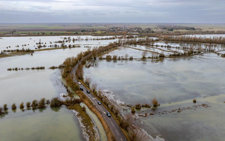
North Wales hit by severe floods
North Wales police said that the A5 is currently closed between Capel Curig and Pentrefoelas due to severe flooding.
“Please avoid these areas,” the police said.
07:42 PM GMT
90 mph winds hit the UK
The Met Office said 90mph winds have hit Capel Curig in north Wales on Sunday.
Meanwhile 76mph gusts were recorded in Loftus, North Yorkshire and 75mph winds blasted Brizlee Wood, near Alnwick in Northumberland, and Emley in Huddersfield.
The latest gusts this evening👇
⚠️ Stay #WeatherAware pic.twitter.com/iMEAb60a5h— Met Office (@metoffice) January 21, 2024
07:40 PM GMT
Planes forced to divert landings over high winds
A plane set to land at Leeds Bradford Airport was forced to divert elsewhere on Sunday afternoon due to high winds.
A flight due to arrive from Gdansk in Poland was diverted to Manchester after it attempted to land. Several flights have also been cancelled at Bristol Airport because of the storm.
06:40 PM GMT
Damage to homes should be expected, forecasters warn
Damage to homes and buildings, falling trees, power cuts, flying debris, large waves and even some flooding in places should also be expected, forecasters have warned.
Winds of 79mph were recorded in Capel Curig, Wales, in the early afternoon.
Agencies across Cumbria have declared themselves on standby for a major incident, while elsewhere a person was hit by debris in Belfast.
05:57 PM GMT
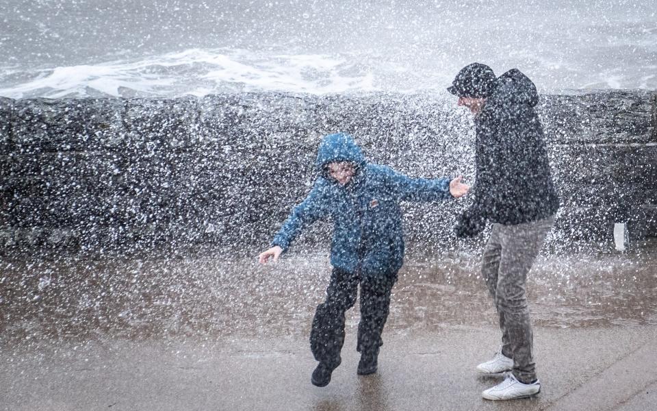
A wet and windy Britain in pictures

05:48 PM GMT
'Don't touch electric cables'
After the storm, the Met Office has said that people should not go near electrical or telephone cables that have been blown down or are still hanging.
They should also steer clear of walls, buildings and trees which appear to have been weakened, while checking on vulnerable neighbours or relatives is also recommended.
05:44 PM GMT
Power cuts hit Northern Ireland
Thousands of homes have been left without power and airport activity has been disrupted due to Storm Isha as severe weather warnings kick in across the island.
A person was hit by debris in Belfast before the most severe part of the storm hit on Sunday evening.
People are urged to heed warnings and not to travel unless necessary in red-warning areas.
Status red wind warnings have been issued for counties Donegal, Galway and Mayo, while status orange/amber warnings are in place for all other counties on the island from this evening.
05:42 PM GMT
Met Office issues tornado warning
A tornado could hit western parts of the UK amid Storm Isha, the Met Office has said.
A “tornado watch” zone was issued for Northern Ireland, as well as parts of Scotland and northern England by the Tornado and Storm Research Organisation (Torro) on Sunday afternoon. It means a “strong tornado” is possible in those regions.
Met Office forecaster Marco Petagna told the PA news agency: “There is a potential that we could see the odd isolated tornado largely tied in with the squally cold front mainly in western parts of the UK on Sunday evening.
“They can cause some significant damage but often on a very localised scale, they often don’t tend to last very long.”
05:36 PM GMT
Watch: British Airways plane aborts landing amid strong winds at Heathrow
05:31 PM GMT
Stay away from walls - and grip steering wheel with both hands
The Met Office has also advised people to stay inside where possible.
If they do need to leave their house, they should steer clear of trees and walls during the strong winds and stick to main roads while driving so they are “less likely” to hit fallen debris and branches.
The Met Office also recommended that drivers grip their steering wheel with both hands and keep more room around the vehicle than usual while travelling.
05:27 PM GMT
Gather batteries and torches, Met Office advises
People are advised to gather batteries and torches as well as other essentials if there are warnings of power outages, while the public should also check if a property is at risk of flooding in areas where a yellow rain warning is in place.
05:18 PM GMT
Tie up your trampolines, batten down the bins
The Met Office warned families that items such as bins, plant pots, garden furniture, trampolines and sheds should be secured, while doors and windows should be fastened.
Those with garage access should park their cars there, or otherwise keep their car away from buildings, trees, walls and fences, they said.
The Met Office added that if chimney stacks are tall or in poor condition then beds should be removed from the area directly below them.
05:07 PM GMT
'Strong and potentially damaging gusts'
🌬️ #StormIsha will bring strong and potentially damaging gusts this evening
🌧️ Rain will continue to spread eastwards, turning particularly heavy in the west
⚠️ Stay #WeatherAware pic.twitter.com/5ZAX4sp3k7— Met Office (@metoffice) January 21, 2024
04:58 PM GMT
Don't sleep near windows, public warned
The Met Office has warned the public not to sleep near windows tonight.
Responding to a worried member of the public, the Met Office tweeted: “The safest place, or where you can minimise the risks of injury in your home, would be anywhere away from glass, such as windows and also rooms where there is no chimney stack above.”
A Met Office spokesperson told the Telegraph the 2023-24 weather season was shaping up to be “one of the stormiest seasons on record”.
04:48 PM GMT
All ScotRail services to cease by 7pm
Scotland’s railway operator has said that all of its services will cease at 7pm on Sunday due to the effects of Storm Isha.
ScotRail has said there will also be no Monday morning rush-hour services, with an amber weather warning for wind set to come into force on Sunday at 6pm.
The warning was previously scheduled to come into effect at 9pm, but has been pushed forward by the Met Office as the weather worsens.
04:47 PM GMT
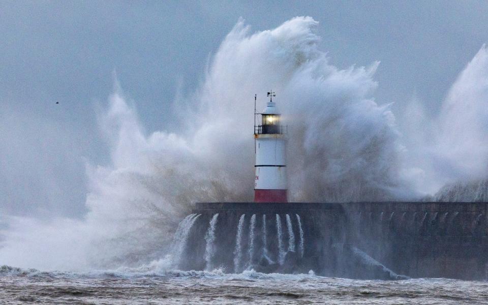
In pictures: Waves pound Newhaven Harbour in East Sussex
04:45 PM GMT
Isha is the ninth named storm of the season
Storm Isha is the ninth named storm to hit the UK since the season began in September.
Each storm is named when it poses a risk to people and they are given names beginning with consecutive letters of the alphabet.
The record number of named storms in one year is when the Met Office began the practice in 2015/16, with Storm Katie being the 11th and final storm of the season.
If there are three more named storms between next week and August, this year will mark a new record.
Cold Arctic air pushing south into North America is making the jet stream more active, the Met Office said, and because it flows from west to east, it is bringing stormier weather to the UK.
04:43 PM GMT
Flights cancelled as BA warns 'check before you fly'
Air traffic control restrictions are in place, leading to some flight cancellations.
National Air Traffic Services (Nats) told the PA news agency: “Due to adverse weather conditions across the UK, temporary air traffic restrictions are in place. Restrictions of this sort are only every applied to maintain safety.
“Our teams are working closely with airports and airlines to minimise disruption. Passengers should check the status of their flight with their airline.”
British Airways said: “Like other airlines, we have had to make schedule adjustments due to the adverse weather conditions across the UK and Europe caused by Storm Isha.”
04:40 PM GMT
Trains restricted to 50mph amid 'significant disruption'
Network Rail said 50mph speed restrictions have been imposed across most routes to keep passengers and trains safe from falling trees and debris blown onto tracks, with disruption likely to continue into Monday morning.
Many train lines across Scotland will close on Sunday night, with ScotRail and Caledonian Sleeper among those stopping some services.
Avanti West Coast has warned against travel, with trains running at reduced speed, while TransPennine Express is advising passengers not to use services between Preston and Edinburgh and Preston and Glasgow in the afternoon.
LNER, advises against travel north of Edinburgh from the afternoon and into Monday, while Transport for Wales cancelled a number of services.
Elsewhere, East Midlands Railway said it expected “significant disruption” on Sunday and Monday and delays and alterations to services, while South Western Railway is reducing its trains in the west of England.
04:39 PM GMT
Flood alerts with four inches of rain to hit some areas
A yellow wind warning also covers the UK, including parts of London and the south-east, while four rain alerts were in place around the country.
Nearly four inches of rain could fall over a few hours in some regions and cause localised flooding, with nine flood warnings already in place across England.
04:38 PM GMT
'Everybody' will be affected by Storm Isha, Met Office says
Two different amber warnings are in place across most of the UK from 6pm to Monday morning, saying 70mph winds should be expected inland, with gusts of 80mph on coastal regions.
In parts of Scotland, northern England and Northern Ireland winds could reach 90mph.
A yellow wind warning also covers the UK, including parts of London and the south-east, while four rain alerts were in place around the country.
The Met Office has said “everybody” will be affected by the storm.
04:36 PM GMT
'Widespread gales to affect the UK'
Met Office meteorologist Tom Morgan said: “We’re expecting widespread gales to affect the UK, amber warnings are in place for large parts of the country.
“There’s the potential for danger-to-life and damaging winds potentially leading to some power cuts in places, some large waves around coastal regions could bring some debris onto roads and trees could come down.”
He added: “We have a wind warning in place across the whole of the UK, it’s pretty unusual for the whole of the country to be under a blanket wind warning.”

